Serra Negra, Cape Verde
| Serra Negra | |
|---|---|
 Serra Negra island of Sal, Cape Verde | |
| Highest point | |
| Elevation | 102.5 m (336 ft) |
| Coordinates | 16°39′31″N 22°53′9″W / 16.65861°N 22.88583°WCoordinates: 16°39′31″N 22°53′9″W / 16.65861°N 22.88583°W |
| Naming | |
| Translation | black mountain (Portuguese) |
| Pronunciation | Portuguese: [ˈsɛʁɐ ˈneɡɾɐ] |
| Geography | |
| Location | island of Sal, Cape Verde |
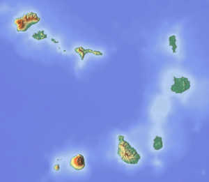
Serra Negra is a hill in the eastern part of the island of Sal in Cape Verde. Its maximum elevation is 102.5 m, the highest point in southern Sal.[1] It stretches for about 2.5 km along the east coast of the island. The headland Ponta da Fragata is situated at the foot of the hill. The nearest settlement is Murdeira, to the west. The mountain forms a part of a protected area as a nature reserve.[2]
Its geology consists of what was an eruptive complex, it was formed about 5.5 million years ago in a new volcanic activity phase. Basalt rocks are common.[3]
See also
References
- ↑ Cabo Verde visor
- ↑ "Protected areas of Cape Verde" (in Portuguese).
- ↑ Holm, P. M. (2008). An 40Ar-39Ar study of the Cape Verde hot spot: Temporal evolution in a semistationary plate environment. 113. Journal of Geophysical Resarch. doi:10.1029/2007JB005339.
The island of Sal, Cape Verde | ||
|---|---|---|
| Settlements | 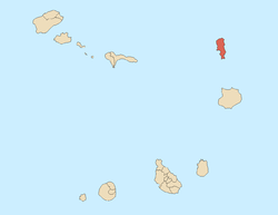 | |
| Parishes | ||
| Points and promontories | ||
| Lighthouses |
| |
| Other geographical features | ||
This article is issued from Wikipedia - version of the 12/4/2016. The text is available under the Creative Commons Attribution/Share Alike but additional terms may apply for the media files.