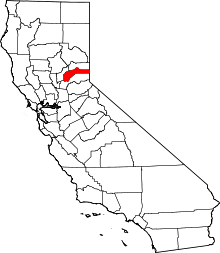
Moores Flat, California
| Moores Flat | |
|---|---|
| Former settlement | |
 Moores Flat Location in California | |
| Coordinates: 39°25′09″N 120°51′03″W / 39.41917°N 120.85083°WCoordinates: 39°25′09″N 120°51′03″W / 39.41917°N 120.85083°W | |
| Country |
|
| State |
|
| County | Nevada County |
| Elevation[1] | 4,144 ft (1,263 m) |
Moores Flat (variant: Moore's Flat; formerly, Clinton[2]) is a former settlement in Nevada County, California. It is situated at an elevation of 4,144 ft (1,263 m) above sea level.[1] Moores Flat is located on the 4.25 miles (6.8 km) north-northeast of North Bloomfield.[2]
Gold rush history
Moores Flat was settled between 1851 and 1852 as a gold rush site with "Marks & Co." one of its few known gold dust dealers.[3] Gold was found buried in tertiary gravel channels.[4]
In 1880, the population was 50.[5] By the early 1900s, its town declined quickly.[6]
The Clinton post office opened in 1854; the name was changed to Moores Flat in 1857.[2] It closed for a time in 1903, and closed for good in 1910.[2] The miner and California State Assemblyman, S. L. Blackwell, was associated with the town's post office in 1880.[7]
The name honors H.M. Moore who built the first house and a store there in 1851.[2]
References
- 1 2 U.S. Geological Survey Geographic Names Information System: Moores Flat, California
- 1 2 3 4 5 Durham, David L. (1998). California's Geographic Names: A Gazetteer of Historic and Modern Names of the State. Clovis, Calif.: Word Dancer Press. p. 525. ISBN 1-884995-14-4.
- ↑ "About Alleghany". holabird.com. Retrieved 2010-04-03.
- ↑ "About Alleghany". holabird.com. Retrieved 2010-04-03.
- ↑ "Nevada County GenWeb Nevada County History". cagenweb.com. Retrieved 2009-05-31.
- ↑ "Grass Valley". origsix.com. Retrieved 2010-04-03.
- ↑ Harvard University. Museum of Comparative Zoology (1880). Memoirs of the Museum of Comparative Zool̈ogy at Harvard College (Public domain ed.). University Press. pp. 403–.
