Whitemud Drive

Whitemud Drive

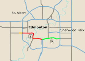
Whitemud Drive traverses south Edmonton, signed as Highway 14 in southeast Edmonton and Highway 2 west of Calgary Trail.
Route information
Maintained by City of Edmonton
Length: 28 km[1] (17 mi)
Component
highways:
Hwy 2, Hwy 14
Major junctions
West end: 231 Street
  Anthony Henday Drive
Fox Drive
Terwillegar Drive
Calgary Trail
Gateway Boulevard
East end: Anthony Henday Drive
Location
Specialized
and rural
municipalities:
Strathcona County
Major cities: Edmonton
Highway system
Provincial highways in Alberta

Whitemud Drive is a major east-west freeway in southern Edmonton, Alberta, Canada, stretching from 231 Street at the western city limit to Anthony Henday Drive just east of Edmonton in Strathcona County. The portion in southeast Edmonton from Anthony Henday Drive to Calgary Trail / Gateway Boulevard is designated as Highway 14, and from there until Anthony Henday Drive in west Edmonton is designated as Highway 2.[2] The portion of Whitemud Drive from 170 Street and 75 Street forms part of the Edmonton inner ring road.

Route description

Whitemud Drive begins in the west at an unsignalized intersection with 231 Street at Edmonton's boundary with Parkland County, and ends in the east at an interchange with the eastern leg of Anthony Henday Drive (Highway 216) at Edmonton's boundary with Strathcona County. The road is preceded by the western segment of Highway 628 from Stony Plain, and succeeded by an eastern segment of Highway 628 to Highway 21. It is signed as Highway 2 between the west leg of Anthony Henday Drive and Calgary Trail/Gateway Boulevard, and Highway 14 between Calgary Trail/Gateway Boulevard and the east leg of Anthony Henday Drive.

Over its course, Whitemud Drive passes at-grade signalized intersections at Winterburn Road (215 Street) and Lewis Estates Boulevard/Guardian Road in the west before passing under the western leg of Anthony Henday Drive (Highway 216), which is accessed through a partially signalized interchange.

Quesnell Bridge carrying Whitemud Drive over the North Saskatchewan River, prior to its widening completed in 2011

Continuing eastward, access is provided through interchanges at 178 Street, 170 Street, 159 Street, 149 Street (limited access), Fox Drive, 53 Avenue, Terwillegar Drive, 119/122 Street, 111 Street, Calgary Trail/Gateway Boulevard (Highway 2), 99 Street, 91 Street, 66/75 Street, 50 Street, 34 Street, 17 Street and the eastern leg of Anthony Henday Drive. Along this portion, Whitemud Drive crosses the North Saskatchewan River on the Quesnell Bridge before Fox Drive, Whitemud Creek (its namesake) before 119/121 Street, Mill Creek before 50 Street, and Fulton Creek after 17 Street. It also passes under a Canadian Pacific rail line before 99 Street and over a Canadian National rail line after 17 Street.

The most recent at-grade intersection to be upgraded to an interchange is 17 Street. The overpass has two lanes open in each direction. Construction is ongoing, with upgrades to 17 Street under the overpass being scheduled for completion in 2012, as well as a third lane for both directions of Whitemud Drive.[3] As a result, Whitemud Drive now has no traffic signals between the western and eastern junctions with Anthony Henday Drive.

Exit list

From west to east. All exits are unnumbered.

Locationkm[1]miDestinationsNotes
Continues as Hwy 628 west (Township Road 524) to Enoch Cree Nation (Stony Plain I.R. No. 135) and Stony Plain
Edmonton0.00.0231 Street / Range Road 261Enters the City of Edmonton at the 231 Street west right of way
53°30′44″N 113°42′48″W / 53.51222°N 113.71333°W / 53.51222; -113.71333 (231 St)
1.60.99Winterburn Road (215 Street)Partial cloverleaf interchange planned
53°30′44″N 113°41′19″W / 53.51222°N 113.68861°W / 53.51222; -113.68861 (Winterburn Rd)
2.31.4Lewis Estates Boulevard / Guardian RoadDiamond interchange planned
53°30′44″N 113°40′39″W / 53.51222°N 113.67750°W / 53.51222; -113.67750 (Lewis Est Blvd / Guardian Rd)
3.62.2 Anthony Henday Drive (Hwy 216; Exit 18)
(Unsigned Hwy 2 north)
Currently partial cloverleaf interchange
Clover-stack interchange planned
53°30′44″N 113°39′33″W / 53.51222°N 113.65917°W / 53.51222; -113.65917 (AHD (west))
West end of Hwy 2 designation • Freeway begins
5.53.4178 Street – West Edmonton MallDiamond interchange
53°30′44″N 113°37′48″W / 53.51222°N 113.63000°W / 53.51222; -113.63000 (178 St)
6.54.0170 StreetWest Edmonton MallCurrently divided diamond interchange
Room for three-level diamond interchange
53°30′43″N 113°36′55″W / 53.51194°N 113.61528°W / 53.51194; -113.61528 (170 St)
7.74.8159 StreetDiamond interchange
Access to 156 Street
53°30′43″N 113°35′48″W / 53.51194°N 113.59667°W / 53.51194; -113.59667 (159 St)
8.95.5149 StreetTrumpet interchange
No eastbound exit
53°30′44″N 113°34′45″W / 53.51222°N 113.57917°W / 53.51222; -113.57917 (149 St)
10.16.3Quesnell Bridge across North Saskatchewan River53°30′23″N 113°34′0″W / 53.50639°N 113.56667°W / 53.50639; -113.56667 (N Sask Rvr)
10.46.5Fox DriveFort Edmonton ParkTrumpet interchange
53°30′13″N 113°34′0″W / 53.50361°N 113.56667°W / 53.50361; -113.56667 (Fox Dr)
12.07.553 AvenueDiamond interchange
53°29′25″N 113°34′19″W / 53.49028°N 113.57194°W / 53.49028; -113.57194 (53 Ave)
12.98.0Terwillegar DriveTrumpet interchange (left exit)
No direct access to and from 53 Avenue
53°28′57″N 113°34′12″W / 53.48250°N 113.57000°W / 53.48250; -113.57000 (Terwillegar Dr)
13.98.6Rainbow Valley Bridge across Whitemud Creek53°28′57″N 113°33′16″W / 53.48250°N 113.55444°W / 53.48250; -113.55444 (Whitemud Cr)
14.89.2119 Street / 122 StreetDiamond interchange
53°28′59″N 113°32′28″W / 53.48306°N 113.54111°W / 53.48306; -113.54111 (119/122 St)
16.410.2111 StreetSouthgate CentreWest end of collector/express lanes
(signals on collector lanes)
53°28′58″N 113°31′1″W / 53.48278°N 113.51694°W / 53.48278; -113.51694 (111 St)
17.310.7106 Street53°28′52″N 113°30′15″W / 53.48111°N 113.50417°W / 53.48111; -113.50417 (106 St)
17.911.1 Calgary Trail (Hwy 2 south) – Airport, Red Deer, CalgarySouthbound one-way
53°28′49″N 113°29′43″W / 53.48028°N 113.49528°W / 53.48028; -113.49528 (Calgary Tr)
18.111.2Gateway BoulevardCity CentreNorthbound one-way
53°28′49″N 113°29′31″W / 53.48028°N 113.49194°W / 53.48028; -113.49194 (Gateway Blvd)
East end of Hwy 2 designation • West end of Hwy 14 designation
18.511.599 StreetEast end of collector/express lanes
53°28′49″N 113°29′10″W / 53.48028°N 113.48611°W / 53.48028; -113.48611 (99 St)
19.812.391 StreetDiamond interchange
53°28′58″N 113°28′0″W / 53.48278°N 113.46667°W / 53.48278; -113.46667 (91 St)
21.413.375 Street / 66 StreetDiamond interchange
53°29′06″N 113°26′33″W / 53.48500°N 113.44250°W / 53.48500; -113.44250 (75/66 St)
23.114.450 StreetDiamond interchange
53°29′14″N 113°25′05″W / 53.48722°N 113.41806°W / 53.48722; -113.41806 (50 St)
24.715.334 StreetDiamond interchange
53°29′14″N 113°23′37″W / 53.48722°N 113.39361°W / 53.48722; -113.39361 (34 St)
26.516.517 StreetDiamond interchange
53°28′55″N 113°22′07″W / 53.48194°N 113.36861°W / 53.48194; -113.36861 (17 St)
Strathcona County28.217.5 Anthony Henday Drive (Hwy 216; Exit 64)
Hwy 14 east Camrose, Wainwright
Leaves the City of Edmonton west of Hwy 216 ramps
Cloverleaf interchange
53°28′58″N 113°20′33″W / 53.48278°N 113.34250°W / 53.48278; -113.34250 (AHD (east))
East end of Hwy 14 designation • Freeway ends
Continues as Hwy 628 east (Township Road 552) to Highway 21
1.000 mi = 1.609 km; 1.000 km = 0.621 mi

References

  1. 1 2 Google (November 10, 2016). "Whitemud Drive in south Edmonton" (Map). Google Maps. Google. Retrieved November 10, 2016.
  2. "Provincial Highway 1-216 Progress Chart" (PDF). Alberta Transportation. March 2015. Archived (PDF) from the original on April 10, 2016. Retrieved October 23, 2016.
  3. "Whitemud Drive–17 Street Interchange". City of Edmonton. November 2011. Retrieved 2011-11-29.
This article is issued from Wikipedia - version of the 11/28/2016. The text is available under the Creative Commons Attribution/Share Alike but additional terms may apply for the media files.