Thelon River
| Thelon River (Akilinik) | |
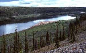
 An oasis-like section of the Thelon, below Warden's Grove | |
| Name origin: "on the other side" in Inuktitut[1][2] | |
| Country | Canada |
|---|---|
| Province | Northwest Territories, Nunavut |
| Source | Whitefish Lake. |
| - location | Northwest Territories |
| - coordinates | 62°30′32″N 106°49′17″W / 62.50889°N 106.82139°W |
| Mouth | Baker Lake |
| - location | near Chesterfield Inlet, Kivalliq Region, Nunavut |
| - coordinates | 64°16′30″N 96°4′35″W / 64.27500°N 96.07639°WCoordinates: 64°16′30″N 96°4′35″W / 64.27500°N 96.07639°W [3] |
| Length | 900 km (560 mi) |
| Basin | 142,400 km2 (55,000 sq mi) [4] |
 Thelon River mouth location | |
The Thelon River (Inuktitut: Akilinik, lit. ‘on the other side’)[5] stretches 900 kilometres (560 mi) across northern Canada. Its source is Whitefish Lake in the Northwest Territories, and it flows east to Baker Lake in Nunavut. The Thelon ultimately drains into Hudson Bay at Chesterfield Inlet.
Geography


The drainage basin of the Thelon River encompasses some 142,400 square kilometres (55,000 sq mi).[4] Located far from almost all human development, the Thelon and its surroundings are entirely pristine wilderness.
The river has a width of up to a kilometer (0.6 mi) along much of its lower section, widening into Beverly, Aberdeen, and Schultz Lakes about 100 kilometres (62 mi) upstream from its mouth at Baker Lake.
Fauna
Approximately 100 moose and more than 2,000 muskoxen forage on the land around the Thelon. 300,000 migrating barren-ground caribou cross the river every fall and spring.
History
The Inuit people, including Caribou Inuit and Copper Inuit, have long occupied the sparsely-populated lands around the Thelon. Artifacts of Inuit hunting and travel (including inukshuk guide stones) are readily observed near the river.
In 1770–71, English explorer Samuel Hearne crossed the Thelon while exploring Canada's northern interior.
Over the winter of 1926–27, Canadian naturalist John Hornby starved to death on the Thelon along with two other men. They had planned to hunt migrating caribou, but failed to find the herd. Nevertheless, on the basis of Hornby's earlier explorations with James Critchell-Bullock in 1923, the Thelon Game Sanctuary was established in 1927, renamed the Thelon Wildlife Sanctuary in 1956.
In 1927(?), the Norwegian explorer and writer Helge Ingstad went by dog sled to the headwaters of the Thelon (Lynx Lake) together with native peoples from the east end of Great Slave Lake. This he detailed in his book The Land of Feast and Famine.
Tourism
In 1990, the lower 545 kilometres (339 mi) of the Thelon were designated a Canadian Heritage River. Although there is no road access to the river, a number of wilderness campers and canoeists visit the Thelon every summer.
See also
- List of longest rivers of Canada
- List of rivers of the Northwest Territories
- List of rivers of Nunavut
References
- ↑ Clarke, Charles Henry Douglas (1940). A Biological Investigation of the Thelon Game Sanctuary. J. O. Patenaude, printer. p. 9.
- ↑ The Musk-ox. Institute for Northern Studies, University of Saskatchewan. 1983. p. 59.
- ↑ "Thelon River". Geographical Names Data Base. Natural Resources Canada. Retrieved 2010-11-24.
- 1 2 "Canada Drainage Basins". The National Atlas of Canada, 5th edition. Natural Resources Canada. 1985. Retrieved 24 November 2010.
- ↑ "The Stefansson-Anderson Arctic Expedition of the American Museum: Preliminary Ethnological Report". Anthropological Papers of the American Museum of Natural History. New York: American Museum of Natural History. 14: 26. 1919. ISSN 0065-9452. OCLC 1116815.
External links
- The Thelon River from the Canadian Heritage Rivers System
- Map of the Thelon River