Scandia, Alberta
For other uses, see Scandia (disambiguation).
| Scandia | |
|---|---|
| Hamlet | |
|
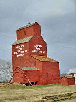
Last remaining prairie grain elevator in the Scandia district. | |
 Scandia Scandia | |
| Coordinates: 50°16′41″N 112°02′48″W / 50.27806°N 112.04667°W | |
| Country |
|
| Province |
|
| Region | Southern Alberta |
| Census division | 2 |
| Municipal district | County of Newell |
| Government | |
| • Governing body | County of Newell Council |
| Population (2011)[1] | |
| • Total | 154 |
| Time zone | MST (UTC-7) |
| Postal code span | T0J 2Z0 |
| Area code(s) | +1-403 |
| Highways | Highway 36 |
Scandia is a hamlet in Alberta, Canada within the County of Newell.[2] It is located 2 kilometres (1.2 mi) west of Highway 36, approximately 34 kilometres (21 mi) southwest of Brooks.
Demographics
As a designated place in the 2011 Census, Scandia had a population of 154 living in 46 of its 55 total dwellings, a 12.4% change from its 2006 population of 137. With a land area of 0.2 km2 (0.077 sq mi), it had a population density of 770/km2 (2,000/sq mi) in 2011.[1]
Attractions
See also
- List of communities in Alberta
- List of designated places in Alberta
- List of hamlets in Alberta
- List of museums in Alberta
- List of provincial historic sites of Alberta
References
- 1 2 "Population and dwelling counts, for Canada, provinces and territories, and designated places, 2011 and 2006 censuses (Alberta)". Statistics Canada. 2012-02-08. Retrieved 2012-04-07.
- ↑ Alberta Municipal Affairs (2010-04-01). "Specialized and Rural Municipalities and Their Communities" (PDF). Retrieved 2010-07-03.
- ↑ Scandia Eastern Irrigation District Museum.
 |
Bassano | Rainier | Brooks |  |
| Lomond | |
Rolling Hills | ||
| ||||
| | ||||
| Enchant | Vauxhall | Hays |
Coordinates: 50°16′41″N 112°02′48″W / 50.27806°N 112.04667°W
This article is issued from Wikipedia - version of the 12/23/2014. The text is available under the Creative Commons Attribution/Share Alike but additional terms may apply for the media files.
