Phlegra Montes
The Phlegra Montes are a system of mountains in the Cebrenia quadrangle of Mars, located at 40.4 degrees north latitude and 163.71 degrees east longitude. They are 1,350 km across and were named after a classical albedo feature name.[1] They form a complex system of isolated hills, ridges and small basins, and it was suggested they have endogenic tectonic origin.[2] [3]
- Map of Cebrenia. Viking II landed near Mie crater. The volcano Hecates Tholus probably has glaciers on its slopes.
- Material moving down slope in the Phlegra Montes, as seen by HiRISE. Movement is probably aided by water/ice.
- Lobate debris apron in the Phlegra Montes, as seen by HiRISE. The debris apron is probably mostly ice with a thin covering of rock debris, so it could be a source of water for future Martian colonists. Scale bar is 500 meters long.
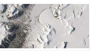
 Romer Lake's Elephant Foot Glacier in the Earth's Arctic, as seen by Landsat 8. This picture shows several glaciers that have the same shape as many features on Mars that are believed to also be glaciers.
References
| Wikimedia Commons has media related to Phlegra Montes. |
- ↑ "Phlegra Montes". Gazetteer of Planetary Nomenclature. USGS Astrogeology Research Program.
- ↑ Moore, J. 1985. Lun. Planet. Sci. Conf. Abs., XVI: 573–574.
- ↑ van Gasselt, S., A.-P. Rossi, C. Orgel, J. Schulz. 2015. PHLEGRA MONTES, MARS : CHRONOLOGY AND DENUDAT ION RATES. 46th Lunar and Planetary Science Conference. 1371.pdf
This article is issued from Wikipedia - version of the 6/16/2016. The text is available under the Creative Commons Attribution/Share Alike but additional terms may apply for the media files.