Oban, New Zealand


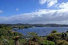
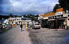
Oban is the principal settlement on Stewart Island/Rakiura, the southernmost inhabited island of the New Zealand archipelago. Oban is located on Halfmoon Bay (sometimes used as an alternative name for the town), on Paterson Inlet. It has aircraft connections with Invercargill and a ferry service to Bluff.
The settlement was named after Oban in Scotland,[1] (An t-Òban in Scottish Gaelic, meaning The Little Bay), due to the strong influence Scottish settlers had in the south of early colonial New Zealand.
According to the March 2001 New Zealand Census of Population and Dwellings, the island's permanent resident population was 387 at that time, a decrease of 30 since 1996. Approximately 80% of these live in Oban. Newer estimates put the population at around 400, and the island has received a moderate boost of commerce and some millions in government funding since tourism increased markedly after the opening of the Rakiura National Park.[2]
Climate
Köppen-Geiger climate classification system classifies its climate as oceanic (Cfb).
| Climate data for Oban (1975−2015, Rainfall 1917−2015) | |||||||||||||
|---|---|---|---|---|---|---|---|---|---|---|---|---|---|
| Month | Jan | Feb | Mar | Apr | May | Jun | Jul | Aug | Sep | Oct | Nov | Dec | Year |
| Record high °C (°F) | 27.0 (80.6) |
28.5 (83.3) |
26.5 (79.7) |
29.0 (84.2) |
19.8 (67.6) |
17.5 (63.5) |
16.0 (60.8) |
17.1 (62.8) |
21.3 (70.3) |
23.9 (75) |
26.5 (79.7) |
27.2 (81) |
29.0 (84.2) |
| Average high °C (°F) | 17.2 (63) |
17.1 (62.8) |
15.9 (60.6) |
14.2 (57.6) |
12.0 (53.6) |
10.1 (50.2) |
9.9 (49.8) |
10.7 (51.3) |
12.2 (54) |
13.4 (56.1) |
14.6 (58.3) |
16.1 (61) |
13.6 (56.5) |
| Daily mean °C (°F) | 13.4 (56.1) |
13.3 (55.9) |
12.1 (53.8) |
10.6 (51.1) |
8.8 (47.8) |
6.7 (44.1) |
6.3 (43.3) |
7.0 (44.6) |
8.4 (47.1) |
9.5 (49.1) |
10.8 (51.4) |
12.4 (54.3) |
9.9 (49.8) |
| Average low °C (°F) | 9.6 (49.3) |
9.4 (48.9) |
8.3 (46.9) |
7.0 (44.6) |
5.5 (41.9) |
3.4 (38.1) |
2.7 (36.9) |
3.5 (38.3) |
4.5 (40.1) |
5.7 (42.3) |
7.0 (44.6) |
8.6 (47.5) |
6.2 (43.2) |
| Record low °C (°F) | 1.0 (33.8) |
1.2 (34.2) |
0.7 (33.3) |
−0.4 (31.3) |
−2 (28) |
−7.3 (18.9) |
−6 (21) |
−3 (27) |
−4.5 (23.9) |
−1.8 (28.8) |
−0.4 (31.3) |
0.6 (33.1) |
−7.3 (18.9) |
| Average rainfall mm (inches) | 133.9 (5.272) |
109.8 (4.323) |
128.2 (5.047) |
132.1 (5.201) |
139.9 (5.508) |
136.9 (5.39) |
113.3 (4.461) |
106.2 (4.181) |
120.9 (4.76) |
134.1 (5.28) |
132.4 (5.213) |
116.4 (4.583) |
1,489.6 (58.646) |
| Average rainy days (≥ 1.0 mm) | 15.3 | 13.6 | 15.4 | 16.0 | 17.9 | 17.8 | 17.0 | 16.5 | 16.0 | 17.0 | 17.0 | 16.1 | 195.5 |
| Average relative humidity (%) (at 9am) | 84.3 | 87.4 | 87.4 | 89.4 | 91.1 | 90.9 | 91.3 | 89.9 | 85.0 | 84.3 | 81.6 | 82.6 | 85.8 |
| Source: CliFlo[3] | |||||||||||||
References
- ↑ Scottish Place Names Around the World - Fife to Oban (from 'rampantscotland.com'. Accessed 2008-10-11.)
- ↑ "Stewart Island gets $5.6m cash boost". New Zealand Herald. APN Holdings. NZPA. 12 July 2005. Retrieved 1 November 2011.
- ↑ "CliFlo - National Climate Database". NIWA. Retrieved 14 December 2015.
Coordinates: 46°54′S 168°08′E / 46.900°S 168.133°E