| [3] |
Name on the Register |
Image |
Date listed[4] |
Location |
City or town |
Description |
|---|
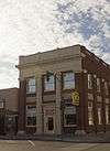
| 1 |
Arizona Bank and Trust |
|
000000001988-02-09-0000February 9, 1988
(#87002557) |
429 Main
32°49′59″N 109°42′42″W / 32.833056°N 109.711667°W / 32.833056; -109.711667 (Arizona Bank and Trust) |
Safford |
|
| 2 |
Richard Bingham House |
|
000000001988-02-09-0000February 9, 1988
(#87002556) |
1208 9th Ave.
32°49′34″N 109°43′05″W / 32.826222°N 109.718114°W / 32.826222; -109.718114 (Richard Bingham House) |
Safford |
|
| 3 |
Bonita Store |
|
000000001998-03-06-0000March 6, 1998
(#98000172) |
1 mile northwest of the junction of State Route 266 and Arizona Industrial School Rd.
32°35′22″N 109°58′08″W / 32.589444°N 109.968889°W / 32.589444; -109.968889 (Bonita Store) |
Bonita |
|
| 4 |
Paul Brooks House |
|
000000001988-02-09-0000February 9, 1988
(#87002559) |
1033 5th Ave.
32°49′40″N 109°42′44″W / 32.827885°N 109.712295°W / 32.827885; -109.712295 (Paul Brooks House) |
Safford |
|
| 5 |
Buena Vista Hotel |
|
000000001988-02-09-0000February 9, 1988
(#87002560) |
322 Main
32°50′00″N 109°42′38″W / 32.833333°N 109.710556°W / 32.833333; -109.710556 (Buena Vista Hotel) |
Safford |
No longer extant[5]
|
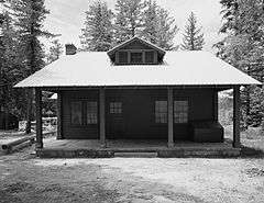
| 6 |
Columbine Work Station |
|
000000001993-06-10-0000June 10, 1993
(#93000516) |
State Route 366 southwest of Safford in the Coronado National Forest
32°42′13″N 109°54′46″W / 32.703611°N 109.912778°W / 32.703611; -109.912778 (Columbine Work Station) |
Safford |
|
| 7 |
T. D. Cross House |
|
000000001988-02-09-0000February 9, 1988
(#87002563) |
908 1st Ave.[6]
32°49′47″N 109°42′28″W / 32.829657°N 109.707904°W / 32.829657; -109.707904 (T. D. Cross House) |
Safford |
|
| 8 |
William Charles Davis House |
|
000000001988-02-09-0000February 9, 1988
(#87002565) |
301 11th St.
32°49′38″N 109°42′37″W / 32.827337°N 109.710283°W / 32.827337; -109.710283 (William Charles Davis House) |
Safford |
|
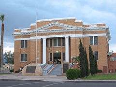
| 9 |
Graham County Courthouse |
|
000000001982-05-25-0000May 25, 1982
(#82002077) |
800 Main St.
32°49′59″N 109°42′57″W / 32.833056°N 109.715833°W / 32.833056; -109.715833 (Graham County Courthouse) |
Safford |
|
| 10 |
Heliograph Lookout Complex |
Upload image |
000000001988-01-28-0000January 28, 1988
(#87002467) |
Coronado National Forest
32°39′00″N 109°50′56″W / 32.65°N 109.848889°W / 32.65; -109.848889 (Heliograph Lookout Complex) |
Old Columbine |
|
| 11 |
Joe Horowitz House |
|
000000001988-02-09-0000February 9, 1988
(#87002566) |
118 Main
32°50′01″N 109°42′31″W / 32.833512°N 109.708573°W / 32.833512; -109.708573 (Joe Horowitz House) |
Safford |
|
| 12 |
House at 611 Third Avenue |
|
000000001988-02-09-0000February 9, 1988
(#87002568) |
611 3rd Ave.
32°49′58″N 109°42′35″W / 32.832846°N 109.709736°W / 32.832846; -109.709736 (House at 611 Third Avenue) |
Safford |
|
| 13 |
Kearny Campsite and Trail |
|
000000001974-10-09-0000October 9, 1974
(#74000454) |
Northeast of Safford off U.S. Route 666
32°53′38″N 109°28′44″W / 32.893841°N 109.478996°W / 32.893841; -109.478996 (Kearny Campsite and Trail) |
Safford |
|
| 14 |
Marijilda Canyon Prehistoric Archeological District |
Upload image |
000000001988-10-02-0000October 2, 1988
(#88001572) |
Address Restricted
|
Safford |
|
| 15 |
Mathew O'Brien House |
|
000000001988-02-09-0000February 9, 1988
(#87002570) |
615 1st Ave.
32°49′57″N 109°42′26″W / 32.832505°N 109.707341°W / 32.832505; -109.707341 (Mathew O'Brien House) |
Safford |
|
| 16 |
Oak Draw Archeological District |
Upload image |
000000001992-11-25-0000November 25, 1992
(#92001564) |
Address Restricted
|
Safford |
|
| 17 |
Oddfellows Home |
|
000000001988-05-12-0000May 12, 1988
(#87002571) |
808 8th Ave.
32°49′49″N 109°43′00″W / 32.830407°N 109.716804°W / 32.830407; -109.716804 (Oddfellows Home) |
Safford |
|
| 18 |
George A. Olney House |
|
000000001988-02-09-0000February 9, 1988
(#87002574) |
1104 Central
32°49′39″N 109°42′42″W / 32.827368°N 109.711544°W / 32.827368; -109.711544 (George A. Olney House) |
Safford |
|
| 19 |
Alonzo Hamilton Packer House |
|
000000001988-02-09-0000February 9, 1988
(#87002575) |
1203 Central
32°49′34″N 109°42′39″W / 32.826077°N 109.710956°W / 32.826077; -109.710956 (Alonzo Hamilton Packer House) |
Safford |
|
| 20 |
Point of Pines |
|
000000001966-10-15-0000October 15, 1966
(#66000182) |
Address Restricted
|
Morenci |
|
| 21 |
Power's Cabin |
|
000000001975-08-13-0000August 13, 1975
(#75000348) |
Northwest of Willcox in the Coronado National Forest
32°35′38″N 110°20′43″W / 32.593889°N 110.345278°W / 32.593889; -110.345278 (Power's Cabin) |
Willcox |
Location of the 1918 Power's Cabin Shootout
|
| 22 |
David Ridgeway House |
|
000000001988-02-09-0000February 9, 1988
(#87002576) |
928 Central
32°49′46″N 109°42′42″W / 32.829474°N 109.711528°W / 32.829474; -109.711528 (David Ridgeway House) |
Safford |
|
| 23 |
Safford High School |
|
000000001988-02-09-0000February 9, 1988
(#87002577) |
520 11th St.
32°49′41″N 109°42′47″W / 32.828056°N 109.713056°W / 32.828056; -109.713056 (Safford High School) |
Safford |
School building built in 1915, listed on the National Register in 1988, and apparently razed in mid-1990s but still not yet delisted.
|
| 24 |
Sierra Bonita Ranch |
|
000000001966-10-15-0000October 15, 1966
(#66000181) |
Southwest of Bonita
32°30′36″N 110°02′15″W / 32.51°N 110.0375°W / 32.51; -110.0375 (Sierra Bonita Ranch) |
Bonita |
Extends into Cochise County
|
| 25 |
Southern Pacific Railroad Depot |
|
000000001988-02-09-0000February 9, 1988
(#87002578) |
808 Central
32°49′52″N 109°42′42″W / 32.831099°N 109.711579°W / 32.831099; -109.711579 (Southern Pacific Railroad Depot) |
Safford |
|
| 26 |
Hugh Talley House |
|
000000001988-02-09-0000February 9, 1988
(#87002580) |
1114 3rd Ave.
32°49′37″N 109°42′37″W / 32.826862°N 109.710299°W / 32.826862; -109.710299 (Hugh Talley House) |
Safford |
|
| 27 |
William Talley House |
|
000000001988-02-09-0000February 9, 1988
(#87002581) |
219 11th St.
32°49′38″N 109°42′35″W / 32.827337°N 109.709788°W / 32.827337; -109.709788 (William Talley House) |
Safford |
|
| 28 |
Webb Peak Lookout Tower |
Upload image |
000000001988-01-28-0000January 28, 1988
(#87002464) |
Off State Route 366
32°42′41″N 109°55′19″W / 32.711389°N 109.921944°W / 32.711389; -109.921944 (Webb Peak Lookout Tower) |
Old Columbine |
|
| 29 |
James R. Welker House |
|
000000001988-02-09-0000February 9, 1988
(#87002582) |
1127 Central
32°49′36″N 109°42′39″W / 32.826563°N 109.710935°W / 32.826563; -109.710935 (James R. Welker House) |
Safford |
|
| 30 |
West Peak Lookout Tower |
Upload image |
000000001988-01-28-0000January 28, 1988
(#87002466) |
Coronado National Forest
32°44′15″N 110°02′15″W / 32.7375°N 110.0375°W / 32.7375; -110.0375 (West Peak Lookout Tower) |
Bonita |
|
| 31 |
David Wickersham House |
|
000000001988-02-09-0000February 9, 1988
(#87002583) |
1101 5th Ave.
32°49′38″N 109°42′43″W / 32.827258°N 109.712064°W / 32.827258; -109.712064 (David Wickersham House) |
Safford |
|
| 32 |
Dan Williams House |
|
000000001988-02-09-0000February 9, 1988
(#87002584) |
603 Relation
32°49′26″N 109°42′51″W / 32.823764°N 109.714059°W / 32.823764; -109.714059 (Dan Williams House) |
Safford |
|
| 33 |
J. Mark Wilson House |
|
000000001988-02-09-0000February 9, 1988
(#87002585) |
712 Relation
32°49′28″N 109°42′57″W / 32.824323°N 109.715893°W / 32.824323; -109.715893 (J. Mark Wilson House) |
Safford |
|
| 34 |
Woman's Club |
|
000000001988-05-12-0000May 12, 1988
(#87002586) |
215 Main
32°49′59″N 109°42′33″W / 32.833056°N 109.709167°W / 32.833056; -109.709167 (Woman's Club) |
Safford |
|
