Mokrosęk
| Mokrosęk | |
|---|---|
| Village | |
 | |
 Mokrosęk | |
| Coordinates: 51°31′N 21°2′E / 51.517°N 21.033°E | |
| Country |
|
| Voivodeship | Masovian |
| County | Radom County |
| Gmina | Jedlińsk |
| Sołectwo | Mokrosęk |
| Area | 5,5 km2 (21 sq mi) |
| Elevation | 147 m (482 ft) |
| Population (2010) | 224 |
| • Density | 4.1/km2 (11/sq mi) |
Mokrosęk ([mɔˈkrɔsɛŋk]; Latin: Mokrosang[1][2][3]) is a village and sołectwo in the administrative district of Gmina Jedlińsk, within Radom County, Masovian Voivodeship, in the east-central Poland. Sołectwo Mokrosęk contains two villages: Mokrosęk and Gryzów.[4]
Geography
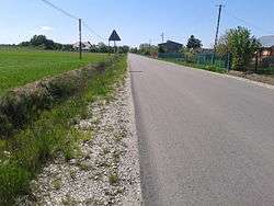
Mokrosęk is located in the Radom Plain.[5] Village covers a total area of 550 hectares (2.1 sq mi).[6] A 5.2 km long[7] Stara Błotnica - Jedlanka powiat road no. 1133W runs through the village, linking the village with the European route E77. Also a 59.8 km long Radomka Community Corporation's Bartodzieje - Uroczysko Grabina cycling trail runs through the village.[8]
History
For the first time Mokrosęk was mentioned in court records of 1411. The village was named then Mocrosank.[6] Another reference is in 1508 tax records.[9] The village is also mentioned in Jan Łaski's liber beneficiorum of 1511-1523.[1]
Demographics
| Year | Population | |
|---|---|---|
| Mokrosęk | Sołectwo Mokrosęk (with Gryzów[lower-alpha 1]) | |
| 1775 | ca. 90[10] | – |
| 1827 | 80[2] | – |
| 1845 | 213[2] | – |
| 1907 | 470[10] | 521[10] |
| 1921 | 359[10] | 431[10] |
| 1940 | 415[10] | 459[10] |
| 1943 | N/A | 465[10] |
| 1947 | 304[10] | 369[10] |
| 1970 | N/A | 289[11] |
| 1971 | N/A | 289[10] |
| 1988 | N/A | 249[11] |
| 1998 | N/A | 249[12] |
| 2002 | N/A | 269[11] |
| 2009 | N/A | 253[12] |
| 2010 | 224[6] | 253[12] |
| 2012 | N/A | 255 |
| Group | Share | |
|---|---|---|
| 1971 | 2010 | |
| 0–18 years | 28,0% | 25,4% |
| 18–59 years (females) 18–64 years (males) |
59,5% | 60,6% |
| 60 years and over (females) 65 years and over (males) |
12,5% | 14,0% |
Notes
References
- 1 2 Łaski, Jan (1880). Liber beneficiorum archidyecezyi gnieźnieńskiej [Liber beneficiorum of Archdiocese of Gniezno] (in Latin and Polish). I. Gniezno. pp. 676–677.
- 1 2 3 Sulimierski, Filip; Chlebowski, Bronisław; Walewski, Władysław (1885). Słownik geograficzny Królestwa Polskiego i innych krajów słowiańskich [Geographical Dictionary of the Kingdom of Poland and other Slavic Countries] (in Polish). VI. Warsaw. pp. 252, 632.
Błotnica, wś i folw., pow. radomski, gm. i par. t. n. (...) W skład gm. wchodzi 28 wsi: (...) Mokrosęk (...); Mokrosęk, dok. Mokrosang, wś i folw., pow. radomski, gm. i par. Błotnica, odl. 16 w. od Radomia. Posiada ziemi dwor. 553 mr., włośc. 237 mr., 37 dm. i 213 mk.; obecnie folw. został rozparcelowany między częściowych nabywców. W 1827 r. 15 dm., 80 mk. Wspomina tę wś Lib. Ben. Łask. (I, 676); translation: Błotnica is a village and a folwark in Radom County; gmina and parish of the same name (...) The gmina contains 28 villages: (...) Mokrosęk (...); Mokrosęk or Mokrosang is a village and a folwark that lies 16 versts from Radom. 553 morgens of land is owned by the Dwór, 237 morgens is owned by the free tenants; there is 37 houses and 213 inhabitants; in present days folwark was parceled for the individual buyers. In 1827, there were 15 houses and 80 inhabitants. The village was mentioned in Łaski's Liber beneficiorum (vol. I, p. 676)
- ↑ Zwoliński, Przemysław; Karpluk, Maria; Kamińska, Maria; Taszycki, Witold (1965). Hydronimia Wisły [Hydronymy of Vistula]. Onomastics Papers (in Polish). 1. Wrocław - Warsaw - Cracow: Zakład Narodowy im. Ossolińskich, Publishing Office of Polish Academy of Sciences. p. 120.
- ↑ "Uchwała Nr XX/41/2008 Rady Rminy Jedlińsk z dnia 26 czerwca 2008 r. w sprawie uchwalenia Statutu sołectwa Mokrosęk" [Gmina Jedlińsk Council's Resolution No. XX/41/2008 of June 26, 2008 on enactment the Statut of the Sołectwo of Mokrosęk] (DOC) (in Polish). Retrieved 2012-05-26.
- ↑ Program ochrony środowiska dla gminy Jedlińsk na lata 2009-2012 z perspektywą na lata 2013-2016 [The Gmina Jedlińsk Environment Protection Programme for 2009-2012 with the perspective for the years 2013-2016] (PDF) (in Polish). Jedlińsk: Urząd Gminy w Jedlińsku. 2009. p. 6. Retrieved 2012-05-26.
- 1 2 3 4 "Uchwała Nr XLII/29/2010 Rady Gminy Jedlińsk z dnia 30 września 2010 r. w sprawie przyjęcia i zatwierdzenia Planu Odnowy Miejscowości Mokrosęk na lata 2010-2018" [Gmina Jedlińsk Council's Resolution No. XLII/29/2010 of September 30, 2010 on enactment and approval of the Revitalisation Plan of the Village of Mokrosęk] (PDF) (in Polish). Retrieved 2012-05-25.
- ↑ Plan rozwoju lokalnego powiatu radomskiego 2007-2013 [2007-2013 Radom Powiat Local Development Plan] (PDF) (in Polish). Radom: Wydział Promocji i Rozwoju Powiatu Radomskiego. 2007. p. 25. Retrieved 2012-05-26.
- ↑ Powiat Radomski. Informator [Radom Powiat. Information Brochure] (PDF) (in Polish). Radom: Starostwo Powiatowe w Radomiu. p. 17. Retrieved 2012-05-26.
- ↑ Pawiński, Adolf (1886). "Polska XVI wieku pod względem geograficzno-statystycznym" [16th century Poland in geographical and statistical aspect]. Źródła dziejowe [Historical sources] (in Polish and Latin). XV. Warsaw: Gebethner & Wolff. p. 473.
Kobylnik, Mokrosszak, n. Janusius Gosczky m. 3 gr. 6 d 9; translation: Kobylnik, Mokrosszak, nobleman Janusz Gosczky, 3 grzywnas, 6 groszs
- 1 2 3 4 5 6 7 8 9 10 11 12 13 Piątkowski, Sebastian (2012). Jedlińsk. Monografia historyczna miejscowości i okolic [Jedlińsk. Historic monograph of town and surrounding area] (in Polish). Jedlińsk: Urząd Gminy w Jedliński. pp. 24, 30, 80, 137, 152, 194, 249, 251, 260, 289, 293, 343, 344, 345, 348, 379, 464. ISBN 978-83-7789-069-1.
- 1 2 3 Wojciechowski, Andrzej, ed. (June 2004). "Ogólna charakterystyka gminy Jedlińsk" [General characteristic of Gmina Jedlińsk]. Program ochrony środowiska Gminy Jedlińsk [Environmental protection program for Gmina Jedlińsk] (DOC) (in Polish). Radom - Jedlińsk: PHU INTER-REM; Urząd Gminy w Jedlińsku. p. 10. Retrieved 2012-11-04.
- 1 2 3 Local Data Bank, Central Statistical Office
Coordinates: 51°31′N 21°2′E / 51.517°N 21.033°E
