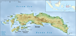
Luhu, Indonesia
| Luhu | |
|---|---|
| Town | |
 Luhu Location in Seram Island | |
| Coordinates: 3°27′26″S 127°57′13″E / 3.45722°S 127.95361°ECoordinates: 3°27′26″S 127°57′13″E / 3.45722°S 127.95361°E | |
| Country | Indonesia |
| Province | Maluku |
| Regency | West Seram |
| Time zone | WITA (UTC+8) |
Luhu is a small town on the southwestern coast of the Indonesian island of Seram.[1] It lies near the end of the Hoamoal Peninsula, between Kulur and Urieng on the tip. Luhu is noted for its Makassan traders, exporting cloves from the port.[2] The clove industry took off in the first half of the 17th century, at the time when Luhu was a vassal of Tidore.[3] The Dutch secured a military post at Luhu.[4]The Luhu language is spoken in the vicinity.[5]
References
- ↑ "Seram Island (map)". Indonesiatravelingguide.com. Retrieved 8 June 2015.
- ↑ Ellen, R. F. (January 2003). On the Edge of the Banda Zone: Past and Present in the Social Organization of a Moluccan Trading Network. University of Hawaii Press. p. 89. ISBN 978-0-8248-2676-5.
- ↑ Reuter, Thomas (1 January 2006). Sharing the Earth, Dividing the Land: Land and Territory in the Austronesian World. ANU E Press. p. 159. ISBN 978-1-920942-70-0.
- ↑ Widjojo, Muridan (10 December 2008). The Revolt of Prince Nuku: Cross-cultural Alliance-making in Maluku, c.1780-1810. BRILL. p. 157. ISBN 978-90-474-2533-5.
- ↑ Frawley, William J. (2003). International Encyclopedia of Linguistics. Oxford University Press. p. 298. ISBN 978-0-19-513977-8.
This article is issued from Wikipedia - version of the 10/28/2016. The text is available under the Creative Commons Attribution/Share Alike but additional terms may apply for the media files.