Lebanon, Oklahoma
| Lebanon, Oklahoma | |
|---|---|
| census-designated place | |
| Coordinates: 33°58′56″N 96°54′27″W / 33.98222°N 96.90750°WCoordinates: 33°58′56″N 96°54′27″W / 33.98222°N 96.90750°W | |
| Country | United States |
| State | Oklahoma |
| County | Marshall |
| Elevation[1] | 676 ft (206 m) |
| Population (2000) | |
| • Total | 327 |
| Time zone | Central (CST) (UTC-6) |
| • Summer (DST) | CDT (UTC-5) |
| ZIP code | 73440 |
| Area code(s) | 580 |
| GNIS feature ID | 1094549 |
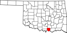
Lebanon is census-designated place (CDP) and unincorporated community in Marshall County, Oklahoma, United States. Although it is unincorporated, it has a post office, with the ZIP code of 73440.[2]
History
Lebanon was settled in the late 19th century as part of the Chickasaw Indian Nation and was part of Pickens County. A Chickasaw Tribal Courthouse was located in Lebanon. About a mile to the east of Hauani Creek is the remains of the Burney School, a tribal school operated by the Chickasaws.[3]
Geography
Lebanon is located on the western end of Lake Texoma, near where the Red River and Hauani Creek enters the lake at 33°58′56″N 96°54′27″W / 33.98222°N 96.90750°W (33.982222, -96.9075).[4]
Demographics
As of the census of 2000, the population of the ZCTA for ZIP Code 73440 was 327.[5]
Economy
Lebanon is primarily a farming area. There are two convenience stores and gas station, and a few other small businesses.
Transportation
Lebanon is served by State Highway 32 and other local roads.
References
- ↑ U.S. Geological Survey Geographic Names Information System: Lebanon, Oklahoma. Retrieved on 2008-02-21.
- ↑ Zip Code Lookup
- ↑ Heritage and Culture - Historic Sites, Chickasaw Nation (accessed February 26, 2008).
- ↑ "US Gazetteer files: 2010, 2000, and 1990". United States Census Bureau. 2011-02-12. Retrieved 2011-04-23.
- ↑ 73440 - Fact Sheet US Census Bureau. Retrieved on 2008-02-21.
