Lånke
| Lånke herred | |
|---|---|
| Former Municipality | |
|
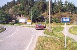
The village of Hell in Lånke | |
 Lånke herred Location in Nord-Trøndelag | |
| Coordinates: 63°26′41″N 10°56′03″E / 63.44472°N 10.93417°ECoordinates: 63°26′41″N 10°56′03″E / 63.44472°N 10.93417°E | |
| Country | Norway |
| Region | Trøndelag |
| County | Nord-Trøndelag |
| District | Stjørdalen |
| Municipality ID | NO-1713 |
| Adm. Center | Hell |
| Area[1] | |
| • Total | 185 km2 (71 sq mi) |
| Time zone | CET (UTC+01:00) |
| • Summer (DST) | CEST (UTC+02:00) |
| Created from | Nedre Stjørdal in 1902 |
| Merged into | Stjørdal in 1962 |
Lånke is a village and former municipality in Nord-Trøndelag county, Norway. It is located in south-central part of the present-day municipality of Stjørdal, south of the Stjørdalselva river. The famous Hell Station in the village of Hell is situated in the westernmost part of Lånke. There are two churches in Lånke: Lånke Church and Elvran Church. Lånke is an area dominated by agriculture and forests.[1]
History
The municipality of Laanke was created on 1 January 1902 when the old municipality of Nedre Stjørdal was split into three new municipalities: Laanke, Stjørdal, and Skatval. Initially, Laanke had a population of 1,449. On 1 January 1914 a small part of Laanke with 38 inhabitants was transferred to Malvik in neighboring Sør-Trøndelag county. The spelling was later changed to Lånke. On 1 January 1962, Lånke was merged with the neighbouring municipalities of Stjørdal, Hegra, and Skatval to form a new, larger municipality of Stjørdal. Prior to the merger, Lånke had a population of 1,967.[2]
References
- 1 2 Store norske leksikon. "Lånke" (in Norwegian). Retrieved 2011-05-11.
- ↑ Jukvam, Dag (1999). "Historisk oversikt over endringer i kommune- og fylkesinndelingen" (PDF) (in Norwegian). Statistisk sentralbyrå.

