Krausnick-Groß Wasserburg
Krausnick-Groß Wasserburg is a municipality in the district of Dahme-Spreewald in Brandenburg in Germany.
Geography
In the middle of the heavily wooded municipality of Krausnick-Groß Wasserburg rise the Krausnick hills (also called the Bergspreewald or Bergspree Woods), which reach a maximum elevation of 144 m above sea level at the summit of the Wehlaberg, and rise about 100 metres above the adjacent Lower Spreewald woods. In the north of the area (in Groß Wasserburg) the Rand Canal branches off the River Spree (Wasserburger Spree) and runs along the Baruth Urstromtal to the Köthener See, which is linked to the River Dahme by the Dahme Flood Relief Canal. The municipality lies ca. 60 km southeast of Berlin.
Demography
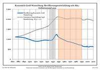
Development of population since 1875 within the current boundaries (Blue line: Population; Dotted line: Comparison to population development of Brandenburg state; Grey background: Time of Nazi rule; Red background: Time of communist rule)
Krausnick-Groß Wasserburg:
Population development within the current boundaries[2]
| Year |
Pop. |
|
|
|---|
| 1875 | 1112 |
| 1890 | 1075 |
| 1925 | 952 |
| 1933 | 943 |
| 1939 | 968 |
| 1946 | 1233 |
| 1950 | 1102 |
| 1964 | 898 |
| 1971 | 853 |
| 1981 | 761 |
|
|
| Year |
Pop. |
|
|
|---|
| 1985 | 720 |
| 1989 | 702 |
| 1990 | 694 |
| 1991 | 661 |
| 1992 | 644 |
| 1993 | 642 |
| 1994 | 629 |
| 1995 | 628 |
| 1996 | 632 |
| 1997 | 623 |
|
|
| Year |
Pop. |
|
|
|---|
| 1998 | 620 |
| 1999 | 648 |
| 2000 | 623 |
| 2001 | 618 |
| 2002 | 609 |
| 2003 | 617 |
| 2004 | 632 |
| 2005 | 632 |
| 2006 | 636 |
| 2007 | 632 |
|
|
| Year |
Pop. |
|
|
|---|
| 2008 | 632 |
| 2009 | 633 |
| 2010 | 619 |
| 2011 | 616 |
| 2012 | 602 |
| | |
|
|
Detailed data sources are to be found in the Wikimedia Commons.[3]
See also
References