Kilmore, County Armagh

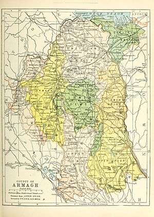
Kilmore or Killmore (from the Irish: Cill Mhór)[1] is a small village, townland and civil parish in County Armagh, Northern Ireland. It lies 2.5 miles north of Richhill and within the Armagh City and District Council area. It had a population of 190 people (74 households) in the 2011 Census.[2] (2001 Census: 111 people)
The site where Kilmore Parish Church now stands arguably predates the much venerated Early Christian cathedral sites of both Armagh and Derry, as the earliest mention of Christian worship here comes from 422 AD. The Square Tower, built in 1613, has walls of great thickness, and are said to enclose the well-preserved round tower of the Monastery of Cill Mhór. Little is known of the monastery, but it is reported to have been founded by Saint Mochta in the 5th century. The monastic site is also associated with the order of Culdees and in history had strong links with the Cathedral of Armagh.
Finds from the area include a 12th-century silver finger ring, a bone comb, fragments of a lignite bracelet, skeletal remains from fields surrounding the church and an early 10th-century copper alloy and crutch-headed pin now in the British Museum.
History
The Troubles
For more information see The Troubles in Kilmore, County Armagh, which includes a list of incidents in Kilmore during The Troubles resulting in two or more fatalities.
People
- Francis Johnston, one of Ireland's most celebrated architects, was a native of Kilmore, County Armagh, who in his later years became known as 'Ireland's Wren'. He designed the principal buildings of the Armagh Observatory which began construction in 1789.
- Thomas Preston an Irish scientist from the 19th century whom published works on heat & light. He also discovered the Zeeman Effect.
Sport
The local GAA club is Ballyhegan Davitts GAC, one of the oldest clubs in County Armagh.
Education
- St. Oliver Plunkett's Primary School
See also
References
- ↑ Placenames Database of Ireland
- ↑ "Kilmore". Census 2011 Results. NI Statistics and Research Agency. Retrieved 22 April 2015.
Coordinates: 54°023′053″N 6°032′049″W / 54.39806°N 6.54694°W
