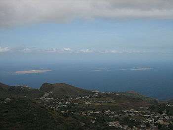
Ilhéu Grande
 | |
| Geography | |
|---|---|
| Location | Atlantic Ocean |
| Coordinates | 14°57′54″N 24°41′56″W / 14.965°N 24.699°WCoordinates: 14°57′54″N 24°41′56″W / 14.965°N 24.699°W |
| Area | 3 km2 (1.2 sq mi) |
| Length | 2.3 km (1.43 mi) |
| Width | 1.1 km (0.68 mi) |
| Highest elevation | 97 m (318 ft) |
| Administration | |
|
Cape Verde | |
| Concelhos (Municipalities) | Brava |
| Demographics | |
| Population | 0 |
Ilhéu Grande is an uninhabited island of Cape Verde. It is the largest of the Ilhéus Secos islet group, located 4 km (2 mi) west of Ilhéu de Cima, the other main islet of the group, and 7 km (4 mi) north of the island Brava. They are administratively a part of the Brava municipality.

The islet is a volcanic seamount and features rocky coastlines. It is mostly barren but has some scattered vegetation.[1] Its length is 2.3 km (1.4 mi) from southwest to northeast and the width is approximately 1.1 km (0.7 mi) from southeast to northwest. The island is an integral nature reserve.[2]
Its average temperature is 20 °C., its highest temperature in November is 23 °C, and the lowest temperature being 18 °C in April cooler than the neighboring island. Average yearly rainfall is 280 mm, the wettest is in September with 125 mm and the driest is in April with only a millimeter.
References
- ↑ "CV009: Ilhéus do Rombo". Sites - Important Bird Areas. BirdLife International. Retrieved 7 July 2012.
- ↑ Nature reserves of Cape Verde