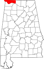
Elgin, Alabama
| Elgin, Alabama | |
|---|---|
| Unincorporated community | |
 Elgin, Alabama  Elgin, Alabama | |
| Coordinates: 34°50′55″N 87°23′28″W / 34.84861°N 87.39111°WCoordinates: 34°50′55″N 87°23′28″W / 34.84861°N 87.39111°W | |
| Country | United States |
| State | Alabama |
| County | Lauderdale |
| Elevation | 640 ft (200 m) |
| Time zone | Central (CST) (UTC-6) |
| • Summer (DST) | CDT (UTC-5) |
| Area code(s) | 256 & 938 |
| GNIS feature ID | 157944[1] |
Elgin, also known as Elgin Crossroads, Ingram's Crossroads, or Marmion, is an unincorporated community in Lauderdale County, in the U.S. state of Alabama. Elgin lies at the intersection of U.S. Route 72 and Alabama State Route 101.
History
Elgin was originally known as Ingram's Crossroads, in honor of Benjamin Ingram, who owned the surrounding land. The name was then changed to Elgin in 1901, in honor of Elgin, Illinois.[2] A post office was in operation under the name Marmion from 1836 to 1849, then under the name Ingram's Crossroads from 1849 to 1858, and finally under the name Elgin from 1901 to 1905.[3]
Fire Protection
Elgin Fire Department covers an area of 8 square miles providing approximately 2500 citizens with fire suppression and various rescue operations. Elgin Fire Department also utilizes hybrid firefighters that are certified Paramedics or EMTs to answer every medical alarm in its coverage area. Elgin Fire Department operates out of two stations, Station 1 being located in town in the Elgin Forest subdivision and Station 2 being located in the Whitehead community both of which house trucks and equipment to handle any kind of emergency.
References
- ↑ "Elgin". Geographic Names Information System. United States Geological Survey.
- ↑ Foscue, Virginia (1989). Place Names in Alabama. Tuscaloosa: The University of Alabama Press. p. 51. ISBN 0-8173-0410-X.
- ↑ "Lauderdale County". Jim Forte Postal History. Retrieved 28 November 2014.
