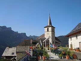
Corbel, Savoie
| Corbel | |
|---|---|
|
The church in Corbel | |
 Corbel | |
|
Location within Auvergne-Rhône-Alpes region  Corbel | |
| Coordinates: 45°25′49″N 5°49′34″E / 45.4303°N 5.8261°ECoordinates: 45°25′49″N 5°49′34″E / 45.4303°N 5.8261°E | |
| Country | France |
| Region | Auvergne-Rhône-Alpes |
| Department | Savoie |
| Arrondissement | Chambéry |
| Canton | Le Pont-de-Beauvoisin |
| Intercommunality | Communauté de communes Cœur de Chartreuse |
| Government | |
| • Mayor (2014–2020) | Jean-Michel Fertier |
| Area1 | 10.31 km2 (3.98 sq mi) |
| Population (2006)2 | 137 |
| • Density | 13/km2 (34/sq mi) |
| Time zone | CET (UTC+1) |
| • Summer (DST) | CEST (UTC+2) |
| INSEE/Postal code | 73092 / 73160 |
| Elevation | 480–1,617 m (1,575–5,305 ft) |
|
1 French Land Register data, which excludes lakes, ponds, glaciers > 1 km² (0.386 sq mi or 247 acres) and river estuaries. 2 Population without double counting: residents of multiple communes (e.g., students and military personnel) only counted once. | |
Corbel is a commune in the Savoie department in the Auvergne-Rhône-Alpes region in south-eastern France. It borders the department of Isère.
Geography
The township of Corbel has three main water streams: Gringalet, Hyères and Guiers Vif. The Gringalet separates Corbel valley from north to south and Guiers Vif goes on its southern border, in the gorges du Guiers. The Gringalet rises in the township, close to les Cruz, and empties into the Guiers Vif. River of Hyères (or Hyère), meanwhile, has its source at the Col des Égaux and down to the township of Saint-Jean-de-Couz. At the level of Corbel valley, if the district is more forested and steepits at his southern border (with Guiers Vif), it is less at the center and at the north. At the Col des Égaux, there are more grasslands and flat surfaces. Two mountains of the Chartreuse Mountains are located on the territory of the township: Roche Veyrand (1356 m) and Thivelet (1231m). Northeast of the town is la Cluse that can reach the col de la Cluse by D45 road.
The town of Corbel (845 m), the center of the township, is located on the east side of Thivelet (or Thimelet), and is about 20 km from Chambéry, by the D45 and the D1006 roads. Between Roche Veyrand and Thivelet lies the hamlet of Les Fiolins (860m). Further north of the township are the hamlets of Les Mathés (900m) and of Les Cruz (1000 m). Morel and La Cochette subdivision are located below the mountain named La Cochette, and near the hamlets of Les Burneys and Les Perrucons. On the other side of the slope of "Le Thimelet" mountain range lies the village of Egaux, near the Col des Égaux.
History
In the eighteenth century, the township experienced a huge growth of population. The population grew up from 260 inhabitants in 1755 to 555 inhabitants in 1801. The township of Corbel became part of the township of Saint-Thibaud-de-Couz during the French Revolution, and later, that of Les Échelles. In the nineteenth century, the township was relatively poor and populated (580 inhabitants in 1848). Famine often threatened Corbelains (inhabitants) because the earth only allowed to grow oats and potatoes. The main resource of the township was the common trade, including the export of timber to Les Échelles and Chambéry. From 1850, with the creation of the main road to Chambéry (D45), the township depopulated, and saw its population divided by two in less than fifty years. With these new roads, famine and poverty have gradually disappeared permanently from the township. In the twentieth century, the wealth of the township and the standard of living of the population increased progressively. In 1994 was created a small road reserved to the residents that directly connects Saint-Pierre-d'Entremont in Savoie to Corbel.
Population and society
Cultural events and festivities
Church and trails, ovens and fountains: Hiking on the trail to see the ovens and fountains of Corbel.
Sports
Many sports activities can be practiced in the township. Trails have been marked for tourists. You can practice cycling, climbing, horse riding, glider and kanoé in the gorges du Guiers Vif. The Fiolins hamlet is the starting point of a path that leads to a via ferrata through Roche Veyrand to get to Saint-Pierre-d'Entremont in Savoie.
Corbel is near skiing and tobogganing stations (Le Desert d'Entremont). There is also the presence of indicated snowshoes paths that connect Corbel to the winter sports resort of the Desert, but also doing a variety of loops in the township only.
Media
- Local TV: France 3 Alpes, TV8 Mont-Blanc
- Local radio: France Bleu Pays de Savoie
Personalities
- Arcabas (1926) - Painter and sculptor, he is one of the authors of contemporary sacred art in France.
Sights
Ovens and fountains
In the town, some basins (fountains) cut in the stone are very famous. Indeed, in 1999, most of the basins of the township were renovated. Ovens of different hamlets are also significant and have their specificities. The walking tour "ovens and fountains" was created specially to visit most of the ovens and fountains of the township.
Other notable sights
- The views over the Chartreuse are countless on the heights of Corbel, we can see in particular the Ruchère, the Grand Som or the Crête des Eparres.
- The church of Corbel dates from the thirteenth century, but it was renovated in the eighteenth century. It is the oldest church of the Entremonts. It features Arcabas's stained glasses from the twentieth century (1997).
- A mill from the sixteenth century is on the road between Les Fiolins and Les Perrucons.
See also
References
| Wikimedia Commons has media related to Corbel (Savoie). |
