Chapecó
| Chapecó | |||
|---|---|---|---|
 | |||
| |||
| Nickname(s): Capital do Oeste (Capital of the West) | |||
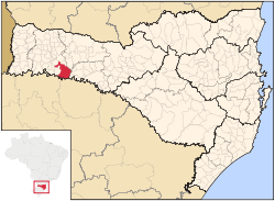
 Location of Chapecó | |||
| Country |
| ||
| Region | South | ||
| State |
| ||
| Founded | August 25, 1917 | ||
| Government | |||
| • Mayor | Luciano José Buligon (PSB) | ||
| Area | |||
| • City | 624.308 km2 (241.047 sq mi) | ||
| • Urban | 113.24 km2 (43.72 sq mi) | ||
| • Metro | 4,938.15 km2 (1,906.63 sq mi) | ||
| Elevation | 674 m (2,211 ft) | ||
| Population (2015)(metro pop IBGE/2010) | |||
| • City | 209,553 | ||
| • Density | 329.64/km2 (853.8/sq mi) | ||
| • Urban | 188,998 | ||
| • Metro | 403,458 | ||
| • Metro density | 81.7/km2 (212/sq mi) | ||
| IBGE | |||
| Time zone | UTC-3 (UTC-3) | ||
| • Summer (DST) | UTC-2 (UTC-2) | ||
| HDI (2000) | 0.834 | ||
| Website | www.chapeco.sc.gov.br | ||
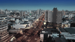
Chapecó is a major city in the western area of the state of Santa Catarina, Brazil, located 630 km west of Florianópolis, the state capital.
As of 2016, it has a population of around 209,553 inhabitants.[1] The city itself has an area of 625 km².[2]
History
Until the 19th century, the area around Chapecó land was under indigenous (mainly Kaingang) and Spanish control, mostly unoccupied by European people and subject to border issues and armed conflicts. Brazilian control was in fact established as a military colony in 1882. Its official status as a municipality was established by state government decree after the Contestado War on August 25, 1917. Its area was then given to a private colonization company[3] which began selling land to people coming mainly from the neighboring state of Rio Grande do Sul.[4] Most of its inhabitants are descended from Italian, German and Polish immigrants.
Demography
Chapecó itself has a population of over 200 thousand inhabitants and its metropolitan area, approximately 400 thousand.[5] It is the hub city of Western Santa Catarina, where there are about two hundred municipalities, summing together more than 2 million inhabitants.
Economy
This region of the state is home of some of the largest meat processing and exporting industrial enterprises such as Sadia and Seara Foods; the farmers are organized in agricultural cooperatives. Chapecó is known as a Brazilian agro-industrial capital, specialized in pork, poultry and technology involved.[6] The city is headquarters of Aurora Central Cooperative and has a plant of BRF S.A. since 1973.
Other major economic sectors are metal mechanics specialized in equipment for slaughterhouses and transportation, plastics and packaging, furniture, beverages, software development and biotechnology. Civil construction and trade are also important source of income.
Chapecó is served by Serafin Enoss Bertaso Airport.
Culture
Sports
Chapecó is home to Associação Chapecoense de Futebol (commonly known as Chapecoense), a club football team that plays at Arena Condá. The club was founded in 1973 and advanced to its most recent spell in Série A in 2014. The club went on to reach the Copa Sudamericana 2016 finals, but most of the team's players and staff were killed in the crash of LaMia Airlines Flight 2933 on 28 November 2016.[7]
Other
The city is the seat of the Roman Catholic Diocese of Chapecó.
See also
References
- ↑ IBGE populations estimative, 2016
- ↑ Chapecó official data, 2015
- ↑ https://www.unochapeco.edu.br/en/ceom/noticias/ceom-unochapeco-recebe-acervo-da-colonizadora-bertaso
- ↑ https://nilson-historia.blogspot.com.br/2009/02/ocupacao-do-territorio-contestado-apos.html
- ↑ Brazilian Institute of Data Geography and Statistics, population statistics in 2013
- ↑ http://www.acichapeco.com.br/links/chapeco---sc
- ↑ Romero, Simon; Casey, Nicholas (29 November 2016). "Brazil's Chapecoense Soccer Team Devastated as Plane Crash Kills Dozens". The New York Times. Retrieved 29 November 2016.
External links
- Mercoagro - International Meat Processing Fair
- Aurora Central Cooperative
- Prefeitura de Chapeco (Portuguese)
- Unochapecó - Universidade Comunitária Regional de Chapecó, local university (Portuguese)
- Unoesc - Universidade do Oeste de Santa Catarina (Portuguese)
Coordinates: 27°05′45″S 52°37′04″W / 27.09583°S 52.61778°W

