Cathedraltown, Ontario
| Cathedraltown | |
|---|---|
| Unincorporated community | |
|
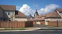
The streetscape of Cathedraltown. | |
 Location within York | |
| Coordinates: 43°53′47″N 79°22′28″W / 43.8964°N 79.3744°WCoordinates: 43°53′47″N 79°22′28″W / 43.8964°N 79.3744°W | |
| Country | Canada |
| Province | Ontario |
| Regional municipality | York |
| City | Markham |
| Established | 2006 |
| Population (2006 est.) | |
| • Total | 3,000 |
| Time zone | Eastern Standard Time (EST) (UTC-5) |
| • Summer (DST) | Eastern Daylight Time (EDT) (UTC-4) |
| Area code(s) | 905 and 289 |
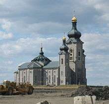
Cathedraltown (Census Tract Number 5350403.03; Population est. 3,000)[1] is a 200-acre town in the city of Markham, Ontario, Canada, located at Major Mackenzie Drive and Highway 404. The community gains its name Cathedraltown because it is landmarked by the abandoned Cathedral of the Transfiguration.
The community is divided into two parts. The part east of Woodbine Avenue is centered on Hazelton Avenue. This part of the community existed first before the newer part west of Woodbine Avenue. The community west of Woodbine Avenue is the heart of the community as it is centred on the Cathedral.
One of the main developers of the Cathedraltown neighbourhood is Monarch (a Taylor Woodrow subsidiary in Canada). They have built most of the homes in this neighbourhood, with the first and second phases already completed. The condominium complex (composed of towers and townhomes) located within this community also began in 2012.
Residential
There are different types of housing offered in this neighbourhood, from 2-storey townhomes, 3-storey townhomes, semi-detached homes, to fully detached homes all in varying sizes (approx. 1500sq.ft. to 4000 sq.ft.). A condominium complex composing of 4-5 storey tall condo towers and condo townhomes are being constructed on the north-west side of the Cathedral, with construction commencing in 2012.
Housing values at Cathedraltown is higher than many-to-most parts of Markham. Townhomes in this neighbourhood starts from high-end $500,000s CAD and fully detached reaching high-end $900,000s CAD near $1,000,000 CAD according to MLS.ca of Canada as of 2015.
The community exemplifies many elements of New Urbanism, including offering a range of residential units, the use of rear laneways and traditional Georgian architecture, as well as the prominence of institutional buildings.
Geography
The population of the community is predominantly people of East Asian and European heritage.
Cathedraltown is located right beside Highway 404 that intersects with Canada's busiest Highway 401, Highway 7 and Express Toll Route (ETR) 407. Highway 404 serves as the main access to Downtown Toronto via the connected Don Valley Parkway.
The community is bounded by Highway 404 to the west, Major MacKenzie Drive to the south, Cachet River to the east, and Elgin Mills Road to the north. The community is sometimes considered to "wrap around" the historical community of Victoria Square.
History
The area was originally farmland, but as the land east and south has been developed, pressure is increasing to redevelop this area into residential neighbourhood. The community began its settlement in early 2006, beginning with the new homes east of Woodbine Avenue, centred on Hazelton Avenue. Settlement to the west of Woodbine Avenue began in 2007. As of January 2012, there are still active, ongoing construction activity of new homes in areas west of the original Woodbine Avenue and the newer Woodbine Avenue By-Pass.
Architecture
Designed under the direction of Donald Buttress, Surveyor Emeritus of Westminster Abbey, Cathedraltown reflects mainly Georgian architecture, which was popular in the U.K. in the 18th century. This style is characterized by boxy, simple and symmetrical buildings, pedimental doors and windows, and free from embellishment.
Amenities
Shopping facilities could be found near the southern end of the community, namely Fieldgate Shopping Centre. It hosts anchors such as the Canadian Tire, Boston Pizza, Shoppers Drug Mart, and several bank branches.
In the future, to the west side of the Cathedral of the Transfiguration will serve as the main amenity of the area. There will be new shopping area, a piazza and parks. The name of this street will be named Roman High Street. The intersection on Woodbine Bypass is already constructed and the street itself is under construction as of 2012 Jan. There is also a new elementary school built, called Sir John A. Macdonald, which was opened on September 2012.
Public Transit
The following bus routes serve the community:
- YRT Route #4 / 4A - Major MacKenzie
- YRT Route #24 - Woodbine
- YRT Route #25 - Major MacKenzie
- YRT Route #80 - Elgin Mills
- YRT Route #452 - Richmond Green School Special
Photo Gallery
|
References
- ↑ The population can only be estimated as the census tract is shared with other rural communities, and communities such as Cachet and Greensborough. Together, this census tract makes up a population of 5,414.
 |
Victoria Square |  | ||
| Richmond Hill | |
Victoria Square, Angus Glen | ||
| ||||
| | ||||
| Cachet |


