Carsley, Virginia
| Carsley, Virginia | |
|---|---|
| Unincorporated community | |
 Carsley, Virginia  Carsley, Virginia | |
| Coordinates: 37°05′45″N 77°00′21″W / 37.09583°N 77.00583°WCoordinates: 37°05′45″N 77°00′21″W / 37.09583°N 77.00583°W | |
| Country | United States |
| State | Virginia |
| County | Surry |
| Elevation | 121 ft (37 m) |
| Time zone | Eastern (EST) (UTC-5) |
| • Summer (DST) | EDT (UTC-4) |
| Area code(s) | 757 |
| GNIS feature ID | 1477180[1] |
Carsley is an unincorporated community in Surry County, Virginia, United States.
Carsley is located at the intersection of VA State Routes 615 (Carsley Road) 40 and 612 (Otterdam Road) north of Waverly and Dendron. The land comprising the community is named for the Carsley's, who owned the land as early as 1812. The Carsley family is the namesake for the area, though the original land grant was given to John Parsons by the King of England on June 5, 1736.
A focal point in Carsley is "Rogers' Store" which is listed in the National Register of Historical Places with the United States Department of the Interior.[2]
References
- ↑ "Spring Grove". Geographic Names Information System. United States Geological Survey.
- ↑ National Park Service (2010-07-09). "National Register Information System". National Register of Historic Places. National Park Service.
Municipalities and communities of Surry County, Virginia, United States | ||
|---|---|---|
| Towns | 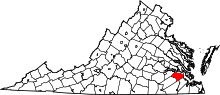 | |
| CDP | ||
| Unincorporated communities | ||
This article is issued from Wikipedia - version of the 7/27/2016. The text is available under the Creative Commons Attribution/Share Alike but additional terms may apply for the media files.