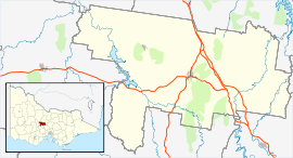
Barfold, Victoria
| Barfold Victoria | |
|---|---|
 Barfold Hall | |
 Barfold | |
| Coordinates | 37°05′S 144°30′E / 37.083°S 144.500°ECoordinates: 37°05′S 144°30′E / 37.083°S 144.500°E |
| Postcode(s) | 3444[1] |
| Location | |
| LGA(s) | Shire of Mount Alexander |
Barfold is a locality situated on the Heathcote-Kyneton Road (C326) in Victoria, Australia. It has a community hall, Barfold Hall, and an Anglican church, Barfold Union Church.[3][4]
A significant geological feature in the area is the Barfold Gorge, a four kilometre long gorge which is up to 80 metres deep and has two waterfalls, basalt columns and a lava cave.[5]
A Barfold Post Office opened on 1 November 1861, some distance to the south of the present township. It was renamed Langley in 1867 when a new Barfold office was renamed from Emberton which had been open a few months. This closed in 1957, as did Langley in 1970[6]
Barfold was the birthplace of William Watt, Premier of Victoria in 1912 and 1913.
References
- ↑ "Postcode Search". Australia Post.
- ↑ "travelmate.com.au". Archived from the original on March 25, 2007.
- ↑ "The Parish of Kyneton - Diocese of Bendigo". Archived from the original on 20 July 2008. Retrieved 20 April 2008.
- ↑ "Mount Alexander Shire - Playground Locations". Retrieved 20 April 2008.
- ↑ Guerrera, Orietta (22 September 2006). "'Secret' Gorge lifts its veil". The Age. Retrieved 20 April 2008.
- ↑ Premier Postal History. "Post Office List". Retrieved 11 April 2008.
External links
![]() Media related to Barfold, Victoria at Wikimedia Commons
Media related to Barfold, Victoria at Wikimedia Commons