Banadir

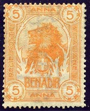
Banadir or Benadir (Somali: Banaadir, Persian: بنادر Banādir) is a coastal region in Somalia. It covers most of the country's central and southern seaboard opposite the Indian Ocean and up to the Juba River, including the capital Mogadishu. From 1885 onwards the Italians made treaties with local sultans on the Somalia northern coast, followed by leasing of ports on the southern coast (known as Benadir or 'Landing Places') in 1892. Italy assumed direct rule after a treaty in 1905.[1] The historical region gives its name to the current administrative region (gobol) of Banaadir, which is smaller and coextensive with Mogadishu.
History
_(14775009264).jpg)
Benadir is derived from the Persian bandar, which means "port" in allusion to the coastal cities of Mogadishu and Barawa. The place name reflects the region's medieval position as a key trade center for the "Horn of Africa" with Persia and the Arabian peninsula. Benadir is also reputed for its special breed of goats.[2]
The original inhabitants of Mogadishu city and the Benadir area were the Hamari people, who are ethnically an amalgam of heterogeneous populations who settled in the area during the Roman empire centuries. Archaeological excavations have demonstrated the existence of trade relations with the Ancient Egypt, Sumerian and Sheba kingdoms for at least a thousand years before Christ. In the first millennium BC the Benadir coast was visited by Phoenician merchants. In the Roman republic centuries between the regions of Zanzibar and the kingdom of Saba (Sheba) was maintained a fluid commercial traffic using maritime monsoon winds: the Sabaeans brought Chinese porcelain and paintings between November and February and returned north with large, spices, gold, ivory and wood. During Augustus times the use of Monsoon winds was increased, with Roman ships going from northern Somalia until India and vice versa.
The main source of the history of the coast of the Indian Ocean is the old Periplus Maris Erythraen written by an anonymous Romano-Greek merchant of Egypt who in 50 AD detailed that the region had an important trade center with its port called Sarapion (modern Mogadishu). Roman coins & artifacts have been found in Damo and Essina, a few km north of actual Mogadishu.
During the Plague of Justinian – that some historians like Theodore Mommsen believe was originated in the Horn of Africa – the ancient Benadir cities were depopulated and a crisis destroyed and impoverished the region in the sixth century.
In 694 AD the Benadir towns of Mogadishu, Merka, Brava and Kismayo sprang into historical existence with the actual names, thanks to the enterprise of Abdul Malik bin Muriami. He placed one of his own followers as governor in each place and declared himself Sultan. These towns on the Benadir coast of the Indian Ocean share to a great extent the characteristics of Swahili culture further south: trading centres, welcoming Arab, Persian and other immigrants, evolving distinctive amalgams both of people groups and language, with tangible forms of settled government and the presence of Islam. The famous explorer Ibn Battuta gave us the best description of Mogadishu city and its Muslim society on the Horn of Africa in the tenth century.
From the tenth century settled in the region some communities of Arab and Persian traders and mixed with the local populations. The first settlers were originally from Al-Hasa (Al-Ahsa) and Sadah in Yemen: 39 families in total and they were four main "clans". Another 12 families "muqarri" came: 12 of Jidati, 6 of Qabiria and 6 of the Ismail; later were joined by other immigrants from Arabia, mainly from northern Yemen (Samand-clans, Abdi Al-awide, Amud Asharaf, Ba-Fadel, Hami Ba-Ba-Jamal Bakr Ba-Muqtar, Bal- Said Hamdan, Omar-Uuduin, Shamsudin, Shawish and Wali). They dealt mainly with fabrics (exported to the Arab territories, Persia, India and China) and they built mosques and other buildings of great architectural value. The actual Benadiri people claim to be descendants of these communities.

Shamsud-Din Abu Abdalla Muhammed known as Ibn Battuta during his visit to the area on 1331 AD noted that Arabic was the language of commercial and literary people on the Bernadir coast and islands. Mogadishu, the center of a thriving weaving industry known as toob benadir (specialized for the markets in Egypt and Syria),[3] together with Merca and Barawa also served as transit stops for Swahili merchants from Mombasa and Malindi and for the gold trade from Kilwa.[4] Jewish merchants from the Hormuz brought their Indian textile and fruit to the Somali coast in exchange for grain and wood,[5]
The Portuguese reached Benadir by the end of fourteenth century. Barawa (Brava) was sacked for three days in 1499 and burned. The 1516 Portuguese Duarte defined Mogadishu as a city of black population named Magadoxo that was ruled by a sultan. Several times the Portuguese wanted to occupy the coast of Benadir without much success. The Portuguese left the region after 1698 AD.
Successively, some Somali kingdoms dominated the regional trade of Benadir, including the Ajuran kingdom, the Adal Sultanate, the Warsangali Sultanate, and the Geledi Sultanate. In the XVII century all the Benadir coast was controlled by the Oman Sultan and when this sultanate was divided in Sultanate of Musqat and Sultanate of Zanzibar after the Napoleon times, the Benadir went under Zanzibar control. Indeed, in 1861, Zanzibar and Oman were divided into two separate principalities: Sayyid Majid bin Said Al-Busaid became the Sultan of Zanzibar, while Sayyid Thuwaini bin Said al-Said, became the Sultan of Oman. The Sultan of Zanzibar controlled a large portion of the African Great Lakes Coast, known as Zanj, as well as trading routes extending much further across the continent, as far as Kindu on the Congo River, and reaching the Benadir.
The Italian penetration in the Benadir coast of Somalia began in 1885 by a commercial company (called "Compagnia del Benadir") that leased the Sultan territory of Obbia. The territory embraced between 4 degrees latitude north and the Juba river, that made border with the British East Africa, also administered by a private company. The main river was the Ueli Xebeli (Wadi Shebeli) and the major cities were Mogadishu, Merka, Brava (Barawa) and Warseij.
The (Benadir) ports management, initially done by the "Compagnia Filonardi" (1893-96) and later by the "Società Anonima Commerciale Italiana del Benadir" (1899-1905) was finally taken by the Italian government that obtained the control of the entire region through an agreement with the British government and the payment of 144,000 British Sterlings to the Zanzibar sultane (London treaty, January 1905).[6]
The Benadir colony was renamed on March 16 of 1905 and became the Italian Somalia with the district Italian administration directly in Benadir, and with the protected Sultanates of Obbia (Hobyo) and Majertin (Majeerteen). In 1926 the territory of Benadir was between the "Basso Uebi-Scebeli", Mogadishu and the "Alto-Uebu Scebeli" (basically the old Sultanate). In the 1930s the Benadir section inside the "triangle Mogadiscio-Merca-Villabruzzi" was the most developed area of "Somalia italiana", with a 114 km railway and many paved roads with the Petrella international airport and the Mogadiscio port: nearly all the Italian Somalians lived there.
In 1951 the "Basso Uebi-Scebeli" and Mogadishu were united in the District of Benadir, and as such integrated in the Republic of Somalia when obtained independence in 1960. The district existed until 1982 when it was created the Banaadir region.
See also
Notes
- ↑ Colonia del Benadir Archived March 4, 2016, at the Wayback Machine.
- ↑ Njoku, Raphael Chijioke (2013). The History of Somalia. ABC-CLIO. p. 69. ISBN 0313378576.
- ↑ Gujarat and the Trade of East Africa p. 35
- ↑ The return of Cosmopolitan Capital:Globalization, the State and War p. 22
- ↑ The Arabian Seas: The Indian Ocean World of the Seventeenth Century By R. J. Barendse
- ↑ Benadir
Bibliography
- Aidid, Mohamed Farrah; Dr. Satya Pal Ruhela (1993). Somalia: From The Dawn of Civilization To The Modern Times. India: Vikas Publishing House PVT LTD. ISBN 0-7069-8004-2.
- Nuredin Hagi Scikei. The Banaadiri: The Renewal of a Millenary Identity (Il risveglio di una millenaria identita'). Ed.Clueb. Bologna, 2002 ISBN 88-491-2031- 1
- Jean Doresse. Histoire sommaire de la corne orientale de l'Afrique Ed. Geuthner. Paris, 1983 ISBN 2-7053-0186-0
- Mantegazza, Vico. Il Benadir. Editore Fratelli Treves. Milano, 1908 ()
Coordinates: 2°07′N 45°24′E / 2.117°N 45.400°E
