Arén
| Arén Areny de Noguera (Ribagorçan) Arén de Noguera (Aragonese) | |
|---|---|
| Municipality | |
| Arén (Spanish) | |
 | |
 | |
 Arén Location in Spain | |
| Coordinates: 42°16′N 0°44′E / 42.267°N 0.733°ECoordinates: 42°16′N 0°44′E / 42.267°N 0.733°E | |
| Country |
|
| Autonomous community |
|
| Province | Huesca |
| Comarca | Ribagorza |
| Judicial district | Barbastro |
| Government | |
| • Alcalde | Miguel Gracia Ferrer (PSOE) |
| Area | |
| • Total | 119 km2 (46 sq mi) |
| Elevation | 709 m (2,326 ft) |
| Population (2008) | |
| • Total | 322 |
| • Density | 2.7/km2 (7.0/sq mi) |
| Demonym(s) | Arenense |
| Time zone | CET (UTC+1) |
| • Summer (DST) | CEST (UTC+2) |
| Postal code | 22583 |
| Website | Official website |
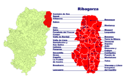
Arén (Spanish: [aˈɾen]), in Ribagorçan: Areny de Noguera[1] (Catalan: [əˈɾɛɲ də nuˈɣeɾə], locally: [aˈɾen de noˈɣeɾa]), or in Aragonese: Arén de Noguera, is a municipality located in the province of Huesca, Aragon, Spain. According to the 2004 census (INE), the municipality has a population of 364 inhabitants.
Villages
These include uninhabited villages:
- Former Arén municipality: Arén, Campamento de Arén, Sobrecastell, Berganuy, Claraválls, Puifel and Soliva.
- Former Cornudella de Baliera municipality (merged in 1965): Rivera de Vall, San Martín, El Sas, Casa Consistorial, Puimolar, L'Hostalet, Vilaplana, Soperún, Iscles, Suerri and Tresserra.
- Former Betesa municipality (merged in 1966): Betesa, Santa Eulalia, Los Molins de Betesa and Obís.
See also
References
- ↑ As shown in the Legislative Decree 2/2006 of 27 December, of the Government of Aragon, by the revised text of the Law on Comarcal Demarcation of Aragon is approved.
External links
This article is issued from Wikipedia - version of the 10/19/2016. The text is available under the Creative Commons Attribution/Share Alike but additional terms may apply for the media files.