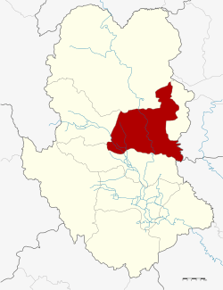
Sawankhalok District
| Sawankhalok สวรรคโลก | |
|---|---|
| Amphoe | |
 Amphoe location in Sukhothai Province | |
| Coordinates: 17°19′0″N 99°49′54″E / 17.31667°N 99.83167°ECoordinates: 17°19′0″N 99°49′54″E / 17.31667°N 99.83167°E | |
| Country |
|
| Province | Sukhothai |
| Seat | Mueang Sawankhalok |
| Area | |
| • Total | 586.192 km2 (226.330 sq mi) |
| Population (2008) | |
| • Total | 87,735 |
| • Density | 151.7/km2 (393/sq mi) |
| Time zone | THA (UTC+7) |
| Postal code | 64110 |
| Geocode | 6407 |
Sawankhalok (Thai: สวรรคโลก) is a district (Amphoe) in the northern part of Sukhothai Province, in the lower north of Thailand.[1][2]
Geography
Neighboring districts are (from the south clockwise) Si Samrong, Thung Saliam, Si Satchanalai, Si Nakhon of Sukhothai Province, Phichai of Uttaradit Province and Phrom Phiram of Phitsanulok Province.
History
The district was originally the capital district of Sawankhalok province, which in 1932 was merged with Sukhothai province.[3] The new province was at first named Sawankhalok, but in 1939 was renamed to Sukhothai and its capital district moved to Sukhothai district.[4]
In 1917, the district was renamed from Mueang (เมือง) to Wang Mai Khon (วังไม้ขอน).[5] 1938 it was named Mueang Sawankhalok (เมืองสวรรคโลก),[6] which was changed to only Sawankhalok in 1939 following the province rename.[4]
Ceramics
The area is well known for its Thai ceramics of the same name, which flourished in the 14th century – 16th century CE.
Administration
The district is subdivided into 14 subdistricts (tambon), which are further subdivided into 143 villages (muban). Suwankhalok is a town (thesaban mueang) and covers the whole tambon Mueang Suwankhalok. There are further 13 Tambon administrative organizations (TAO).
| No. | Name | Thai | Villages | Inh.[7] |
|---|---|---|---|---|
| 1. | Mueang Sawankhalok | เมืองสวรรคโลก | 9 | 18,051 |
| 2. | Nai Mueang | ในเมือง | 14 | 8,327 |
| 3. | Khlong Krachong | คลองกระจง | 9 | 5,092 |
| 4. | Wang Phinphat | วังพิณพาทย์ | 4 | 804 |
| 5. | Wang Mai Khon | วังไม้ขอน | 11 | 1,778 |
| 6. | Yan Yao | ย่านยาว | 12 | 8,767 |
| 7. | Na Thung | นาทุ่ง | 12 | 5,307 |
| 8. | Khlong Yang | คลองยาง | 12 | 7,139 |
| 9. | Mueang Bang Yom | เมืองบางยม | 5 | 2,921 |
| 10. | Tha Thong | ท่าทอง | 8 | 3,668 |
| 11. | Pak Nam | ปากน้ำ | 12 | 6,982 |
| 12. | Pa Kum Ko | ป่ากุมเกาะ | 14 | 7,991 |
| 13. | Mueang Bang Khlang | เมืองบางขลัง | 13 | 5,038 |
| 14. | Nong Klap | หนองกลับ | 8 | 5,870 |
References
- ↑ http://www.sukhothai.go.th/3584/data/data_01.htm
- ↑ http://tourisminvest.tat.or.th/en/component/content/article?id=62
- ↑ พระบรมราชโองการ ประกาศ ยุบรวมท้องที่บางมณฑลและบางจังหวัด (PDF). Royal Gazette (in Thai). 48 (0 ก): 576–578. 1932-02-21.
- 1 2 พระราชกฤษฎีกาเปลี่ยนนามจังหวัดและอำเภอบางแห่ง พุทธศักราช ๒๔๘๒ (PDF). Royal Gazette (in Thai). 56 (0 ก): 351–353. 1939-04-17.
- ↑ ประกาศกระทรวงมหาดไทย เรื่อง เปลี่ยนชื่ออำเภอ (PDF). Royal Gazette (in Thai). 34 (0 ก): 40–68. 1917-04-29.
- ↑ พระราชกฤษฎีกาเปลี่ยนนามจังหวัด และอำเภอบางแห่ง พุทธศักราช ๒๔๘๑ (PDF). Royal Gazette (in Thai). 55 (0 ก): 658–666. 1938-11-14.
- ↑ "Population statistics 2008". Department of Provincial Administration.
External links
- amphoe.com (Thai)