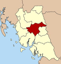
Mueang Trang District
| Mueang Trang เมืองตรัง | |
|---|---|
| Amphoe | |
 Amphoe location in Trang Province | |
| Coordinates: 7°33′30″N 99°36′36″E / 7.55833°N 99.61000°ECoordinates: 7°33′30″N 99°36′36″E / 7.55833°N 99.61000°E | |
| Country |
|
| Province | Trang |
| Area | |
| • Total | 548.6 km2 (211.8 sq mi) |
| Population (2005) | |
| • Total | 147,034 |
| • Density | 268.0/km2 (694/sq mi) |
| Time zone | ICT (UTC+7) |
| Postal code | 92000 |
| Geocode | 9201 |
Mueang Trang ( Thai: เมืองตรัง, also Mueang Thap Thiang ( Thai: เมืองทับเที่ยง ) is the capital district (amphoe mueang) of Trang Province, Thailand. The city (thesaban nakhon) has a population of 59,637 (2005) and covers the whole tambon Thap Thiang of Mueang Trang District.
History
Mueang Trang or the previous name Thap Thiang, became the capital district of Trang Province in 1915, when the capital was moved inland from Kantang, which was prone to flooding.
Geography
Neighboring districts are (from the south clockwise) Na Yong, Yan Ta Khao, Kantang, Sikao, Wang Wiset, Huai Yot of Trang Province and Si Banphot of Phatthalung Province.
Administration
The district is divided into 15 sub-districts (tambon), which are further subdivided into 118 villages (muban). The city (thesaban nakhon) Trang covers the whole tambon Thap Thiang. The township (thesaban tambon) Khlong Teng covers parts of tambon Na Tham Nuea. There are further 14 tambon administrative organizations (TAO).
|
 |
Missing numbers are tambon which now form Na Yong District.
External links
- http://www.mueangtrang.dopatrang.go.th District website (Thai)