Allt-yr-yn
| Allt-yr-yn | |
 Allt-yr-yn |
|
| Population | 8,782 (2011 census)[1] |
|---|---|
| OS grid reference | ST295885 |
| Principal area | Newport |
| Country | Wales |
| Sovereign state | United Kingdom |
| Post town | NEWPORT |
| Postcode district | NP20 5 |
| Dialling code | 01633 Savoy exchange |
| Police | Gwent |
| Fire | South Wales |
| Ambulance | Welsh |
| EU Parliament | Wales |
| UK Parliament | Newport West |
Coordinates: 51°35′N 3°01′W / 51.59°N 3.02°W
Allt-yr-yn (Welsh: Allt-yr-ynn) is a suburb of the city of Newport, south-east Wales.
Pronounced by English-speaking locals as "Olt-er-reen", the spelling should include two Ns at the end, as "Allt-yr-ynn". The name means "The slope (allt) of the ash trees (ynn which is the plural of onnen – ash tree)" in Welsh.
Allt-yr-yn forms an electoral ward (district) and coterminous community (parish) of the city. It is mainly residential and contains many large houses built in the early part of the 20th century. Some of the district is built upon the Ridgeway, Newport, with some of the ward offering views of surrounding areas such as Twmbarlwm. The area is governed by the Newport City Council.

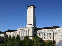
Towards the City Centre, Allt-yr-yn is home to the offices of Newport City Council, at the Civic Centre, of which its clock tower can be seen for miles around.
University of Wales, Newport had a campus located in Allt-yr-yn. It served as the university's Science, IT and Business faculty. before moving to a site with a new £35 million complex on the banks of the River Usk in central Newport. The new campus formally opened in January 2011.[2] Initially the new campus will house the Newport Business School and design, film and media elements of the Newport School of Art, Media and Design.
On the west side of Allt-yr-yn heights there is a Local Nature Reserve containing ancient woodland, meadows and five ponds. Between 1934 and the mid-1960s this was home to an open-air swimming baths,[3] and is now managed by a volunteer group known as WING – Wildlife in Newport Group. The nature reserve borders the Crumlin Arm of the Monmouthshire and Brecon Canal which runs parallel to the M4 Motorway at Allt-yr-yn. Lock 2 has been restored by volunteers and work has started on lock 3. Lock 1 disappeared under road works in Newport early in the 20th century.[4]
A permanent military presence was established in the area with the completion of the Cavalry Barracks in 1845.[5]
There was once a hospital in the ward, but this was deemed surplus to requirements and the site is now the Allt-yr-yn Heights estate.
References
- ↑ "Newport ward 2011. Retrieved 5 April 2015".
- ↑ University Of Wales, Newport
- ↑ "Open-air swimming baths, Allt-yr-yn, Newport". Retrieved 7 December 2014.
- ↑ BBC – South East Wales Reserves – Allt-yr-yn
- ↑ "Raglan House, Raglan Barracks, Allt-yr-Yn". British Listed Buildings. Retrieved 7 December 2014.
External links
| Wikimedia Commons has media related to Allt-yr-yn. |
- University of Wales, Newport
- Newport City News
- www.geograph.co.uk : photos of Allt-yr-yn and surrounding area