Zarcero (canton)
| Alfaro Ruiz (Zarcero) | |||
|---|---|---|---|
|
Cantón | |||
 | |||
| |||
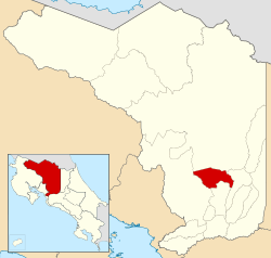
 Location of Alfaro Ruiz in Alajuela Province | |||
| Country | Costa Rica | ||
| Province | Alajuela | ||
| Founded | 21 June 1915 | ||
| Area | |||
| • Total | 155.13 km2 (59.90 sq mi) | ||
| Population (June 2013) | |||
| • Total | 13,215 | ||
| • Density | 85/km2 (220/sq mi) | ||
Zarcero is the 11th canton in the province of Alajuela in Costa Rica.[1] The canton covers an area of 155.13 square kilometres (59.90 sq mi),[2] and has a population of 13,215 (estimate as of 2003).[3] The capital city of the canton is Zarcero.
It is a diamond-shaped canton, with the Río Espina (Thornbush River) as the border on the northwest and the southwest sides. The Río Toro (Bull River) forms the southeastern border, and the Río La Vieja (Old Woman River) borders the northeast.
Hiking trails, pure water creeks, friendly people, nice landscapes and natural attractions are features of the area.
Districts
The canton of Zarcero is subdivided into seven districts (distritos):[1]
| District | Postal code | Alt. (m) | Area (km2) | Pop. (2008) | Coordinates |
|---|---|---|---|---|---|
| Zarcero | 21101 | 1,736 | 12.01 | 4,376 | 10°11′08″N 84°23′39″W / 10.18556°N 84.39417°W |
| Barrios (neighborhoods): Cantarranas, Santa Teresita | |||||
| Laguna | 21102 | 1,840 | 23.08 | 1,780 | 10°12′40″N 84°24′08″W / 10.21111°N 84.40222°W |
| Poblados (villages): Peña | |||||
| Tapesco | 21103 | 1,821 | 6.2 | 1,227 | 10°13′10″N 84°24′16″W / 10.21944°N 84.40444°W |
| Guadalupe | 21104 | 1,602 | 22.35 | 857 | 10°11′06″N 84°24′45″W / 10.18500°N 84.41250°W |
| Poblados (villages): Anateri, Bellavista, Morelos | |||||
| Palmira | 21105 | 2,010 | 30.29 | 1,484 | 10°12′40″N 84°22′48″W / 10.21111°N 84.38000°W |
| Poblados (villages): Picada | |||||
| Zapote | 21106 | 1,580 | 43.03 | 819 | 10°13′36″N 84°25′35″W / 10.22667°N 84.42639°W |
| Poblados (villages): Quina (part), San Juan de Lajas, Santa Elena | |||||
| Brisas | 21107 | 1,850 | 18.17 | 1,825 | 10°13′53″N 84°23′40″W / 10.23139°N 84.39444°W |
| Poblados (villages): Ángeles, Brisa, Legua | |||||
History
The canton was established by a decree of June 21, 1915. It was originally named Alfaro Ruiz in honor of Colonel Juan Alfaro Ruiz, a hero of the National Campaign of 1856. Today Alfaro Ruiz is called Zarcero.
References
- 1 2 "División Territorial Administrativa de Costa Rica" (PDF) (in Spanish). Instituto de Fomento y Asesoria Municipal (IFAM). 5 May 2009. Archived from the original (PDF) on August 2, 2015.
- ↑ Instituto Geográfico Nacional (IGN), 2001.
- ↑ Estadísticas Vitales 2013 - INEC
Coordinates: 10°13′N 84°24′W / 10.217°N 84.400°W
.jpg)