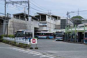
YRP Nobi Station
YRP Nobi Station YRP野比駅 | |
|---|---|
 YRP Nobi Station | |
| Location |
Nobi 1-9-1, Yokosuka, Kanagawa (神奈川県横須賀市野比1-9-1) Japan |
| Operated by | Keikyu |
| Line(s) | Keikyu Kurihama Line |
| Connections |
|
| Other information | |
| Station code | KK68 |
| History | |
| Opened | 1963 |
| Previous names | Nobi (until 1998) |
| Traffic | |
| Passengers (2008) | 20,974 daily |
YRP Nobi Station (YRP野比駅 Waiārupī Nobi-eki) is a railway station on the Keikyu Kurihama Line in Yokosuka, Kanagawa, Japan, operated by the private railway operator Keikyu.
Lines
YRP Nobi Station is served by the Keikyu Kurihama Line, and is located 7.2 km from Horinouchi Station, and 59.5 km from Shinagawa Station in Tokyo.
Station layout
YRP Nobi Station has two opposing elevated side platforms. The station acts as a passing loop on the single track section of the Kurihama Line between Keikyū Kurihama Station and Keikyū Nagasawa Station.
Platforms
| 1 | ■Keikyū Kurihama Line | Miurakaigan・ Misakiguchi |
| 2 | ■Keikyū Kurihama Line | Yokosuka-Chūō・ Yokohama ・ Shinagawa ・ Haneda Airport ・ Oshiage |
Adjacent stations
| ← | Service | → | ||
|---|---|---|---|---|
| Keikyū Kurihama Line | ||||
| Keikyū Kurihama | Ltd. Exp. | Keikyū Nagasawa | ||
| Keikyū Kurihama | Rapid Ltd. Exp. | Keikyū Nagasawa | ||
| Keikyū Kurihama | Keikyu Wing | Keikyū Nagasawa | ||
History
YRP Nobi Station opened on November 1, 1963 as the southern terminal station for the Kurihama Line, At that time, it was named simply Nobi Station (野比駅). It became a through station on March 27, 1966 when the Kurihama Line was extended to Tsukuihama Station. With the opening of the nearby Yokosuka Research Park, the station was renamed on April 1, 1998. It is the fourth station in Japan (and the first non-JR station) to have letters of the alphabet in its name.
References
- Miura, Kazuo. Keikyū Kakuekiteisha to Kamakura Monogatari. Inban Publishing (1998). ISBN 4-8083-0624-7 (Japanese)
External links
| Wikimedia Commons has media related to YRP Nobi Station. |
- Keikyu YRP Nobi Station (Japanese)
Coordinates: 35°12′43.59″N 139°41′05.94″E / 35.2121083°N 139.6849833°E