Wolseley, South Australia
| Wolseley South Australia | |||||||||||||
|---|---|---|---|---|---|---|---|---|---|---|---|---|---|
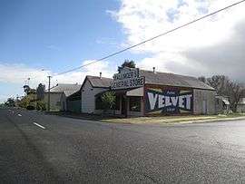
 Wolseley historic shop with restored advertising sign on the side | |||||||||||||
 Wolseley | |||||||||||||
| Coordinates | 36°22′0″S 140°54′0″E / 36.36667°S 140.90000°ECoordinates: 36°22′0″S 140°54′0″E / 36.36667°S 140.90000°E | ||||||||||||
| Population | 341 (2006 census)[1] | ||||||||||||
| Postcode(s) | 5269 [2] | ||||||||||||
| Location |
| ||||||||||||
| LGA(s) | Tatiara District Council | ||||||||||||
| State electorate(s) | Goyder | ||||||||||||
| Federal Division(s) | Barker | ||||||||||||
| |||||||||||||
Wolseley (formerly Tatiara) is a small South Australian town near the Victorian border. It is five kilometres south of the Dukes Highway and 13 kilometres east of Bordertown. It was first proclaimed a town in 1884.
Railway
The Adelaide-Wolseley railway was opened from Adelaide east to Wolseley railway station in the early 1880s built to 1,600 mm (5 ft 3 in) broad gauge. The Serviceton railway line from Melbourne reached Serviceton in Victoria in 1886, and the three miles from Wolseley to Serviceton was completed by the South Australian Railways in 1887, completing a broad gauge rail link between Adelaide and Melbourne. Around the same time, the Mount Gambier railway line 1,067 mm (3 ft 6 in) narrow gauge railway extended to Wolseley station from the south, creating a break-of-gauge rail junction.
By May 1883, rail construction had not yet been completed, but trains were able to operate regularly from Bordertown on the Adelaide line and from Custon on the Mount Gambier line, continuing through Naracoorte to Kingston SE.[3]
In 1881, the Government of South Australia authorised the construction of a 3 ft 6 in (1,067 mm) railway from "University Block No. 3" near the southern border of the Hundred of Tatiara to Border Town.[4] It had previously authorised the construction from Naracoorte to that point in 1879.[5]
In the 1950s the break-of-gauge was abolished by the conversion of the Mount Gambier line to broad gauge. The line to Mount Gambier has been out of use since the conversion of the Adelaide - Melbourne line to 1,435 mm (4 ft 8 1⁄2 in) standard gauge on 12 April 1995, pending possible conversion to standard gauge.
History
The town was surveyed in 1884, and initially named Tatiara, which was described as an "Aboriginal word from the Jackegilbrab Tribe which HC Talbot states is divided into six clans (Kooinkill, Wirriga, Chala, Camiaguigara, Niall & Nunkoora)". The railway station was named after Lord Wolseley, who was the Commander-in-Chief of the British Army. The name of the town was changed to match the name of the station on 20 February 1941.[6]

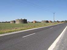
Early in World War II, No. 12 Inland Aircraft Fuel Depot was established at Wolseley, with an initial capacity of 1.27 megalitres (280,000 imp gal; 340,000 US gal) in three tanks camouflaged to look like farm buildings. The depot started operations in 1942 and three additional tanks were added later. It was disbanded on 14 June 1944.[7] It is listed on the South Australian Heritage Register as the Wolseley Inland Aircraft Fuel Depot.[8]
Wolseley is in the Tatiara District Council, the state electoral district of MacKillop and the federal Division of Barker.
Railway containers
In 1936, to help overcome some of the inconveniences of the break of gauge, containers were introduced to allow though shipment of goods without the need for transshipment.[9]
References
| Wikimedia Commons has media related to Wolseley, South Australia. |
- ↑ Australian Bureau of Statistics (25 October 2007). Wolseley(State Suburb). 2006 Census Quickstats. Retrieved on 2008-05-29
- ↑ Wolseley Postcode Australia Post. Retrieved on 2008-05-29
- ↑ "WOLSELEY.". The Border Watch. Mount Gambier, SA: National Library of Australia. 12 May 1883. p. 2. Retrieved 4 August 2015.
- ↑ Tatiara and Bordertown Railway 44 Vic., 1881, No. 200, Government Printer, 2009-05-14, retrieved 4 August 2015
- ↑ Naracoorte and Tatiara Railway 43 Vic., 1879, No. 131, Government Printer, 2008-06-20, retrieved 4 August 2015
- ↑ "Placename Details: Wolseley". Government of South Australia. SA0027361, SA0016322, SA0065544, SA0044004. Retrieved 4 August 2015.
- ↑ Interpretative sign at the site west of Wolseley
- ↑ "Former Wolseley Inland Aircraft Fuel Depot including pump house, drum filling platform and six fuel tanks". South Australian Heritage Register. Department of Environment, Water and Natural Resources. Retrieved 5 June 2016.
- ↑ "New Freight Containers For S.E. Railway Services.". The Advertiser (Adelaide, SA : 1931 - 1954). Adelaide, SA: National Library of Australia. 23 April 1936. p. 19. Retrieved 26 October 2011.