Winterland Airport
| Winterland Airport | |||||||||||
|---|---|---|---|---|---|---|---|---|---|---|---|
 | |||||||||||
| Summary | |||||||||||
| Airport type | Public | ||||||||||
| Operator | Government of Newfoundland and Labrador | ||||||||||
| Location | Winterland, Newfoundland and Labrador | ||||||||||
| Time zone | NST (UTC−03:30) | ||||||||||
| • Summer (DST) | NDT (UTC−02:30) | ||||||||||
| Elevation AMSL | 156 ft / 48 m | ||||||||||
| Coordinates | 47°08′13″N 055°19′45″W / 47.13694°N 55.32917°WCoordinates: 47°08′13″N 055°19′45″W / 47.13694°N 55.32917°W | ||||||||||
| Map | |||||||||||
 CCC2 Location in Newfoundland and Labrador | |||||||||||
| Runways | |||||||||||
| |||||||||||
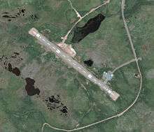
Winterland Airport (TC LID: CCC2), is 2.5 nautical miles (4.6 km; 2.9 mi) southwest of Winterland, Newfoundland and Labrador, Canada.
The airport is classified as an airport of entry by Nav Canada and is staffed by the Canada Border Services Agency (CBSA). CBSA officers at this airport can handle general aviation aircraft only, with no more than 15 passengers.[1]
References
- 1 2 Canada Flight Supplement. Effective 0901Z 15 September 2016 to 0901Z 10 November 2016
- ↑ Synoptic/Metstat Station Information
| By name | |
|---|---|
| By location indicator | |
| By province/territory | |
| By region | |
| National Airports System | |
| Related | |
| |
This article is issued from Wikipedia - version of the 12/4/2016. The text is available under the Creative Commons Attribution/Share Alike but additional terms may apply for the media files.