Wiesbadener Kreuz
| Wiesbadener Kreuz | |
|---|---|
|
A sign gantry over the western approach of the A 66 to Wiesbadener Kreuz. | |
| Location | |
| Hofheim, Hesse, Germany | |
| Coordinates: | 50°3′20.1″N 8°23′16.4″E / 50.055583°N 8.387889°ECoordinates: 50°3′20.1″N 8°23′16.4″E / 50.055583°N 8.387889°E |
| Roads at junction: | |
| Construction | |
| Opened: | 23 September 1939 |
| Map | |
 | |
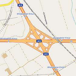
The Wiesbadener Kreuz is a full cloverleaf interchange near the Hessian state capital of Wiesbaden in Germany where the Autobahnen A3 and A66 meet. It lies in the municipality of Hofheim. The interchange was opened in 1939 and was one of the first interchanges in Germany.
Used by approximately 190,000 vehicles per day, it is one of the most frequented interchanges in Hesse and Germany.[1]
The portion of the A3 between the Wiesbadener Kreuz and Kreuz Fürth/Erlangen is traditionally one of the most congested sections of Autobahn in Germany.[2]
Between 2016 and 2018, the interchange will be upgraded and improved to avoid the daily congestions during the rush hour.[3]
References
- ↑ Manuelle Straßenverkehrszählung 2010 des BVM Page 4 and 28 of PDF (337 KB)
- ↑ Staff writer (16 October 2009). "Koalition will Standstreifen bei Stau freigeben" [Coalition wants the release of the emergency lane during congestion]. Die Welt. Retrieved 26 December 2015.
- ↑ Allgemeine Zeitung – Abschied vom Kleeblatt - Wiesbadener Autobahn-Kreuz wird erneuert, April 2011
External links
![]() Media related to Wiesbadener Kreuz at Wikimedia Commons
Media related to Wiesbadener Kreuz at Wikimedia Commons
This article is issued from Wikipedia - version of the 12/26/2015. The text is available under the Creative Commons Attribution/Share Alike but additional terms may apply for the media files.