Western Suburbs (Mumbai)
| Western Suburbs | |
|---|---|
| Precinct of Greater Mumbai | |
|
| |
 The Western Suburbs precinct is shown in green | |
| Coordinates (Bandra): 19°03′16″N 72°50′26″E / 19.054444°N 72.840556°E | |
| Country | India |
| State | Maharashtra |
| District | Mumbai Suburban |
| Metro | Mumbai |
| Wards |
HE, HW, KE, KW, PS, PN, RS, RC, RN |
| Area | |
| • Total | 405.9 km2 (156.7 sq mi) |
| Population (2011) | |
| • Total | 6,220,000 |
| • Density | 15,000/km2 (40,000/sq mi) |
| Time zone | IST (UTC+5:30) |
| Western Suburbs: Population Growth | |||
|---|---|---|---|
| Census | Pop. | %± | |
| 1971 | 1,705,490 | — | |
| 1981 | 2,858,170 | 67.6% | |
| 1991 | 3,947,990 | 38.1% | |
| 2001 | 5,095,680 | 29.1% | |
| Source: MMRDA[1] Data is based on Government of India Census. | |||
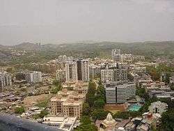
The Western Suburbs is the western precinct of the city of Mumbai, India. The Western Suburbs consist of Andheri, Bandra, Borivali, Dahisar, Goregaon, Jogeshwari, Juhu, Kandivali, Khar, Malad, Santacruz and Vile Parle. Geographically, the Western Suburbs lie at the western part of Salsette Island.
The Western Suburbs are some of the oldest suburbs of the city. In particular, Bandra has existed as a separate town almost as long as Mumbai. The area started its history as a bunch of fishing villages. Mumbai's only river, the Mithi, flows through this area and also serves as a sewage line. In the 1980s, a well-intentioned attempt to set up a new downtown away from Nariman Point resulted in the establishment of the Bandra Kurla Complex. Most of the larger financial banks and companies moved to this place.[2]
Apart from the usual suburban sprawl, this area has some nice beaches, especially near Malad. Jogeshwari has hot springs which are reputed to have medicinal properties. Borivali is the entry point for the Sanjay Gandhi National Park, which is why the wildlife reserve is more popularly known as Borivali National Park.[3]
Many software and BPO companies have their offices in and around SEEPZ in Andheri. The western suburbs also boast of the Juhu Beach. These suburbs can get extremely crowded in the evenings, with very severe traffic jams.[2]
Division
The city of Mumbai lies on Salsette Island. Administratively it has two official divisions: Mumbai City district and Mumbai Suburban district. Mumbai City district consists of the island city that lies to the south of Salsette Island. This region is called South Mumbai. The western part of Mumbai Suburban district (to the west of Sanjay Gandhi National Park) is called the Western Suburbs and the eastern part of the district is called the Eastern Suburbs.
The northernmost portion of the island which is outside Mumbai city limits, lies in Thane District.
South Mumbai, the Western suburbs and the Eastern Suburbs are not officially defined divisions of Mumbai and different people may include different areas in each division. This article uses the most popular divisions.
Transport
Air
Chhatrapati Shivaji International Airport is located in Andheri. Most 5-star hotels are located nearby. Juhu Aerodrome, which is used by small private aircraft and as a heliport, is located in Juhu.
Rail
Each of the suburbs that make up the Western Suburbs has a railway station. Bandra, Andheri and Borivali are important junctions. A branch of the Harbour Line terminates at Andheri. Bandra is also terminus for long-distance trains. The Borivali Railway Station is a terminus for all slow, semi-fast and fast trains on the Mumbai Suburban Railway system of Maharashtra state.
Road
The Western Express Highway (WEH) connects Dahisar, the northern most suburb of the Western Suburbs, to Bandra and then Worli and South Mumbai via the Bandra–Worli Sea Link. WEH runs parallel to the Western Line, which is on its western side.
SV Road (Swami Vivekananda Road) is another major road in the Western Suburbs, it begins in Bandra in the south and ends at the Dahisar Flyover junction with the Western Express Highway in the north.
However, connectivity from the Eastern Suburbs is poor. The Andheri-Ghatkopar Link Road, Jogeshwari – Vikhroli Link Road (JVLR), the Andheri-Kurla Road and the Santa Cruz – Chembur Link Road (SCLR) are the major road links between the Eastern and Western Suburbs.
Bus services are provided by Brihanmumbai Electric Supply and Transport (BEST). The "200" & "300" series buses serves the Western Suburbs.[2]
See also
Notes
- ↑ Population and Employment profile of Mumbai Metropolitan Region, p. 7
- 1 2 3 Mumbai/Western Suburbs. Wikivoyage.
- ↑ Mumbai/Northwest. Wikivoyage.
References
| Wikivoyage has a travel guide for Western Suburbs - Mumbai. |
- "Population and Employment profile of Mumbai Metropolitan Region". Mumbai Metropolitan Region Development Authority (MMRDA). Archived from the original (PDF) on 28 December 2009. Retrieved 4 June 2010.

