Wabash and Erie Canal
| Wabash and Erie Canal | |
|---|---|
|
A restored section of canal in Delphi, Indiana | |
The Wabash and Erie Canal was a shipping canal that linked the Great Lakes to the Ohio River via an artificial waterway. The canal provided traders with access from the Great Lakes all the way to the Gulf of Mexico. Over 460 miles long, it was the longest canal ever built in North America.
The canal known as the Wabash & Erie in the 1850s and thereafter, was actually a combination of four canals: the Miami and Erie Canal from the Maumee River near Toledo, Ohio to Junction, Ohio, the original Wabash and Erie Canal from Junction to Terre Haute, Indiana, the Cross Cut Canal from Terre Haute, Indiana to Worthington, Indiana (Point Commerce), and the Central Canal from Worthington to Evansville, Indiana.
Construction
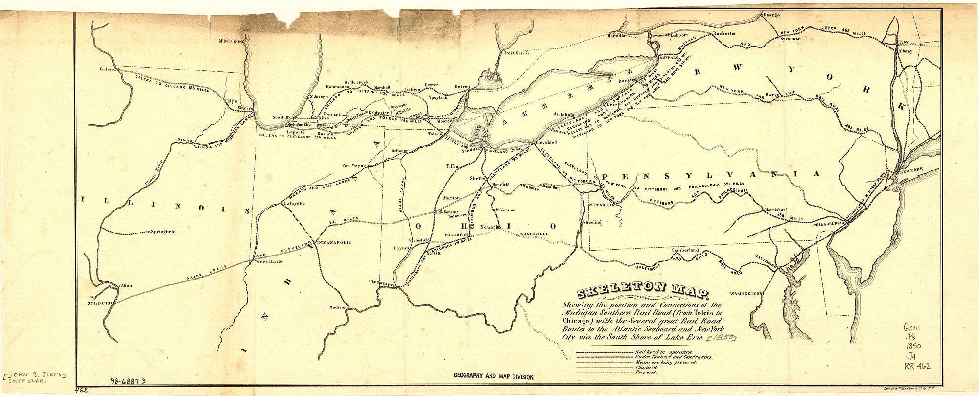
In this 1850 map, the original Wabash and Erie Canal is shown as part of an emerging system canals and rail lines
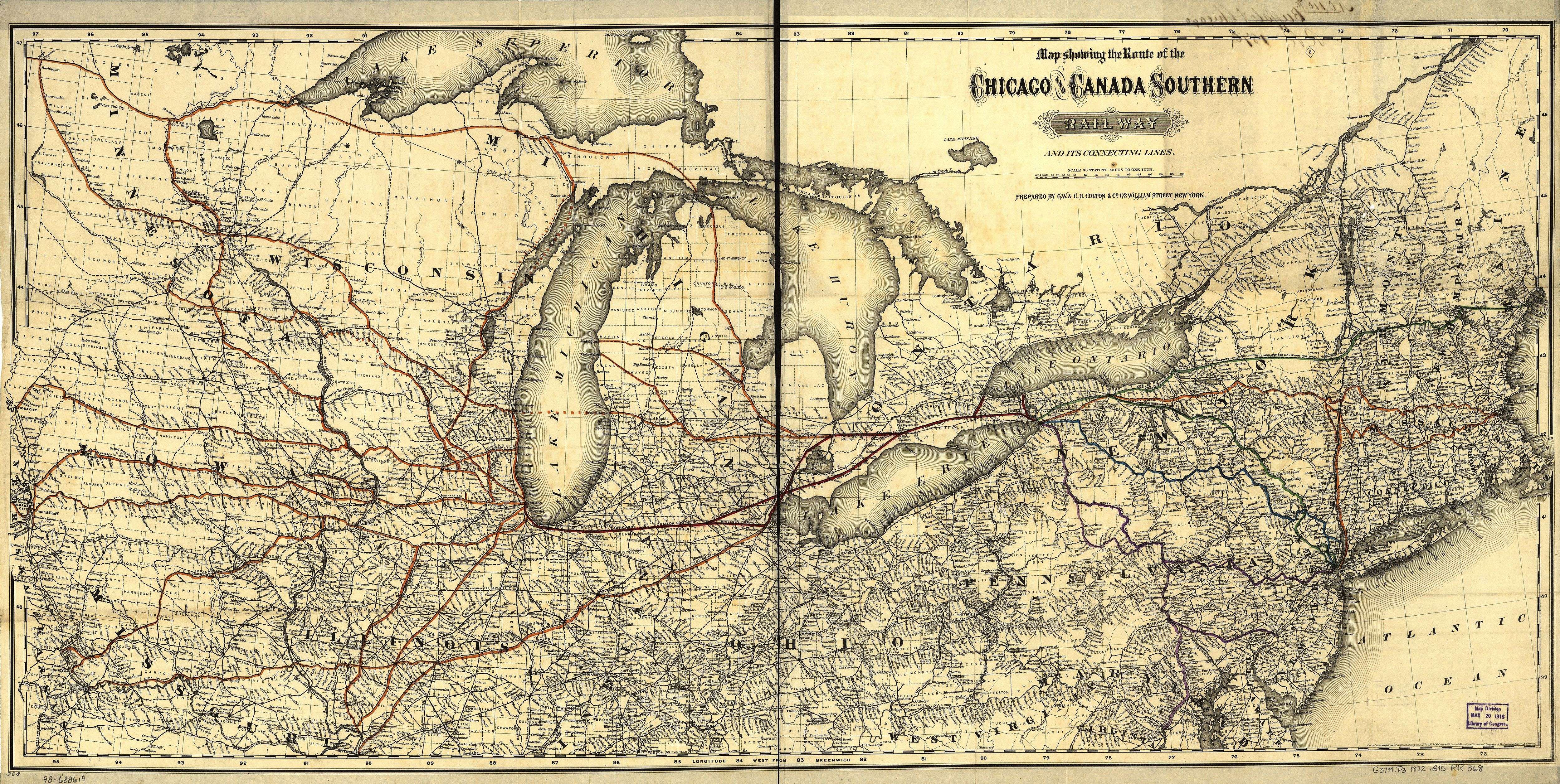
by 1872, the Toledo, Wabash and Western Railway (shown in red) connected Toledo, Fort Wayne, and Lafayette. The original canal, with its slow pace and maintenance issues, struggled to compete with many rail lines in operation in the 1870s.
The United States Congress provided a land grant on March 2, 1827 for the canal's construction. On January 5, 1828, the Indiana General Assembly accepted the grant and appointed three commissioners.[1] These commissioners concluded that the canal would have to extend into Ohio and petitioned that state to appoint a commission of their own. The state legislature approved the plan and new commissioners appointed. After several legislative battles begun by proponents of the railroad, the Indiana General Assembly approved the borrowing of $200,000 to begin construction. February 22, 1832 ground was broken and construction began.[2] Construction of the canal reached Logansport by 1837.[3]
The Panic of 1837 devastated Indiana's program of internal improvements, but did not stop construction entirely.[4] The canal reached Lafayette by 1843, Terre Haute by 1848 and Evansville by 1853.[5] During the summer of 1991, the Gronauer Lock was uncovered at New Haven, Indiana, during the construction of I-469. This is the only intact wooden timber lock discovered. Part of the Gronauer Lock is now on display at the Indiana State Museum.
The high-line sections of the canal proved to be high maintenance and the cost of their repair is what eventually led to the collapse of the canal company. The worst offender was the common muskrat which were plentiful in the area. They would build burrows in the sides of the canal walls and once they tunneled through on the opposite side the water quickly washed out the entire wall of the levee which rendered the canal useless until it could be repaired.[6]
Operation
.png)
The canal began operation in the summer of 1843. It only operated for about a decade before it became apparent that the canal was not economicially viable. Even when canal boats were operated at extremely slow speeds, the banks rapidly eroded, and the canal had to be constantly dredged to be operable. Terre Haute, Indiana, housed the headquarters of the canal from 1847 through 1876, when the canal lands were sold at an auction conducted by resident trustee Thomas Dowling at the Vigo County Courthouse.
The last canalboat on the Wabash Canal made its last docking in 1874 in Huntington, Indiana, but other sections shut down years earlier. In 1887, Paulding County, Ohio residents put the final nail in the canal system's coffin: unhappy with mosquitoes breeding in the stagnant waters of Six Mile Reservoir, they cut the dike and drained it in the Reservoir War. There were several other "reservoir wars" during the canal's colorful history over the same issue, including the Clay County Canal War in Indiana.
The right-of-way through Fort Wayne was purchased by the New York, Chicago and Lake Erie Railway (the Nickel Plate Road) which ran from Buffalo to Chicago. This allowed the railway to run straight through the heart of a major midwestern city without razing a single home. The canal right-of-way was also directly adjacent to downtown, which made the new railway quite convenient for passengers and many businesses. The canal from Napoleon to Toledo was paved over to make U.S. Route 24.
Route

The Wabash & Erie Canal travels 497 miles from Toledo, Ohio on Lake Erie to Evansville, Indiana on the Ohio River. Its route takes it along the left bank or north side of the Maumee River from Toledo to the south side right bank near Defiance, Ohio and eventually to the headwaters at Fort Wayne, Indiana. From here, it follows the historic Indian portage to the Wabash River. Following the Wabash River, again on its north side, this is now the right bank. The canal heads downstream to Delphi. At this location, it crosses to the left bank (eastside). Continuing down the Wabash to Terre Haute, the canal turns southeast from the Wabash, using several other riverways, until reaching the Ohio River in Evansville.
Maumee River Section
The Miami and Erie Canal runs from Toledo to Cincinnati. The route as far as the Napoleon Bend was used by the Wabash & Erie Canal to reach Lake Erie. The joint route includes the following towns and cities.
Toledo, Bend View Metro park (towpath), Side Cut Metro park (towpath & 3 of 6 locks). Providence (operating canal section).
Maumee, Waterville, Providence/Grand Rapids (locks and other canal features), Independence.
Defiance At Defiance, the Miami and Erie Canal crossed the Maumee River and turned south up the Auglaize River. This route carried the canal southward to the divide with the Great Miami and eventually the Ohio River at Cincinnati. Meanwhile, the Wabash & Erie Canal continued west along the Maumee River to the portage at Fort Wayne, Indiana. The two canals split at Junction, Ohio.
- Two canals using the same infrastructure at Providence, Ohio.
- Entrance from the Maumee River to the Miami and Erie
- Providence lock looking west into the old canal bed.
- Restoration of the mill and store at Providence.
New Haven-Indiana
Gronauer Lock No 2 "Wabash and Erie Canal lock was discovered here June 1991 during excavation for highway construction. It was built 1838–1840 by Henry Lotz and named for lock keeper Joseph Gronauer. The rare, well-preserved timber-frame design lock measured 115 by 40 feet; lock chamber was 90 by 15 feet; two-thirds of the total structure was excavated and removed."
"Numerous artifacts and 750 pieces of timber were recovered. After extensive preservation treatment, approximately 5 percent of total lock structure is included in an Indiana State Museum Exhibit. Wabash and Erie Canal, America’s longest at approximately 460 miles, linked Lake Erie at Toledo, Ohio with Ohio River at Evansville 1853."[7]
Fort Wayne is located at an old portage between the Maumee River and the Wabash River. Here, the canal crossed 5 miles to the Little Wabash River and headed downstream through Indiana. Since this was the highest point on the canal (i.e. the summit), Fort Wayne became known as the "Summit City." Located along this section is the Vermilyea Inn Historic District.
Wabash River Section
Huntington - intersection of North Jefferson Street and East Washington on North Jefferson Street
Canal Landing on Washington Street - The Huntington Landing started 120 feet west on Washington St and continued to the lock at Cherry St. The Wabash & Erie canal was 4 feet deep and 100 feet wide as this point. Other locks were at First St. and Byron St. The Canal was completed from Fort Wayne to Huntington on July 3, 1835, and from Toledo to Evansville, 459 miles, in 1854. The Canal preceded the railroad to Huntington by 20 years, spurring early settlement. The Canal was abandoned in 1873.[7]
Rook House - at the intersection of East Park Drive (U.S. 224) and Warren on East Park Drive. located on the south wall of the building.
The first permanent hotel of Huntington was built of stone on this site by General John Tipton in 1835. Standing on the bank of the Wabash and Erie Canal, it was a commercial, political and social center. From 1862 to 1872 it housed one of the first public schools and was destroyed in 1873.[8]
Forks of the Wabash Park (Museum),
- Rook House Marker
- Rook House
- Burks Lock Historic Marker
- Map of the Wabash & Erie Canal
- Historic Canal Route, now US 24
Rich valley, Peru, Logansport,
Delphi, Canal Interpretive Center (watered section, canal boat, bridge and mill site). Here in Delphi, the canal crossed the Wabash from the right bank (northside) to the left bank (southside). A dam was built across the Wabash River at Pitts to create a slack water area to allow the boats to cross the river without an aqueduct.
- Water section of the canal in Delphi, Indiana
- Reconstructed Canal Town - Canal Park Visitor Center
Lafayette, Attica, Fountain County, Covington, Montezuma, Terre Haute
Cross Cut Canal Section
Eel River Section Between Terre Haute and Worthington, is 42 miles (68 km) long. Legally referred to as the Cross Cut Canal.[9] This created a link to the Central Canal and a route to Evansville. Since no other section of the Cross Cut Canal was contemplated nor built, it is considered historically to be part of the Wabash and Erie Canal. The canal had to overcome the 78 feet (24 m) at the summit.[9] Water was supplied by the Eel River Feeder,[9] the Birch Creek Reservoir and Splunge Creek Reservoir. Work started in 1836 but abandoned in 1839. The project was completed in 1850, serving the Wabash and Erie Canal system until 1861. The Cross Cut Canal is considered to be part of the Wabash & Erie Canal System.[9]
Eel River Feeder Dam is 180 feet (55 m) long and 16.5 feet (5.0 m) high. It was completed in 1839. It was constructed to carry enough water from the river to enable navigation of boats on the proposed Crosscut Canal. The feeder dam was repaired and extended in 1850 to be 264 feet (80 m) long.[10]
West Fork of the White River
From Newberry south, the W&E Canal followed the route of the Central Canal. The Central Canal was planned from Logansport, through Indianapolis and south to Evansville. Only the section from Newberry south and a few miles in Indianapolis were built. Newberry, Edwardsport, Petersburg, Francisco (Pigeon Creek section begins), Evansville, Indiana.
Travel
Travel along the canal was accomplished by canal packets. There were freight and passenger packets. The passenger packet consisted of a series of rooms along the length. Towards the front was the main saloon. Here meals were taken. This room was converted into a men's dorm for sleeping. The ladies saloon was towards the back of the boat. It was the women's sleeping dorm at night.
Packets were pulled by three horses, oxen, or a mixture of oxen and horses. The most common problems identified in journals of that time were, heat, mosquitoes, and the close proximity to the other passengers.[11]
- Passenger Packet, courtesy of the Canal Interpretive Center, Delphi, IN
 Except for the draft, this represents an average packet, Forks of the Wabash Museum, Huntington, IN
See also
Notes
- ↑ Charles R. Poinsatte, Fort Wayne During the Canal Era 1828-1855 ([Indianapolis:] Indiana Historical Bureau, 1969), 33-34.
- ↑ Poinsatte, 35-36
- ↑ Poinsatte, 80.
- ↑ Poinsatte, 81.
- ↑ Andrew R. L. Cayton, Frontier Indiana (Indianapolis: Indiana University Press, 1996), 285.
- ↑ Dunn, Jacob Piatt (1919). Indiana and Indianans. American Historical Society. p. 399.
- 1 2 Indiana State Historic Marker
- ↑ Daughters of the American Revolution Historic Marker
- 1 2 3 4 http://www.visitgc.com/where-to-go/innovation/wabash-erie-canal-corridor-area/; downloaded 2014-04-24
- ↑ Crosscut Canal Eel River Feeder Dam; 4 miles north of Clay City on SR 59 at Eel River bridge, northwest corner. (Clay County, Indiana); 1999; Indiana Historical Bureau, Canal Society of Indiana; ID#: 11.1999.1
- ↑ Indiana, A History; William E. Willson, Indiana University Press; Bloomington; 1966; pg 178
Additional Sources
- Wabash & Erie canal, Lock No. 2 (Gronauer Lock), HAER No. IN-74; Historic American Engineering Record, Department of the Interior; Philadelphia, Pennsylvania; 1994
External links
- Canal Construction in Indiana - The Indiana Historian, September 1997
- Wabash and Erie Canal in Carroll County
- The Early History of Fort Wayne
- Historical Marker Database
- Wabash and Erie Canal Journey
- Maumee Valley Heritage Corridor
- Gronauer Lock discovery
- Historic American Engineering Record (HAER) No. IN-74, "Wabash & Erie Canal, Lock No. 2, 8 miles east of Fort Wayne, adjacent to U.S. Route 24, New Haven, Allen County, IN", 63 photos, 4 measured drawings, 23 data pages, 11 photo caption pages
- HAER No. IN-80, "Wabash & Erie Canal (Partial), Parallel to the Wabash River at the western edge of downtown Lafayette, Lafayette, Tippecanoe County, IN", 35 photos, 17 data pages, 7 photo caption pages
.png)


