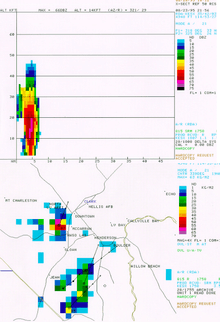
Vertically integrated liquid

Vertically integrated liquid (VIL) is an estimate of the total mass of precipitation in the clouds. The measurement is obtained by observing the reflectivity of the air which is obtained with weather radar.[1]
Definition
Reflectivity (Z) in dBZ represents the intensity of radar echoes returning from a clouds. According to the wavelengths used in weather radars, only precipitation can be noted (drizzle, rain, snow, hail), not the cloud droplets nor water vapor, so Z is proportional to the rain rate. Using the sum in the vertical of Z, one can find the total mass of water equivalent in and below the precipitating cloud and that is what is VIL.
From the studies of Marshall and Palmer on the drop size distribution of rain drops, it is possible to find VIL:[2][3][4]
Where :
- Zi and Zi+1 are reflectivities of two scanning angles and (Zi + Zi+1)/2 is the mean value in the layer.
- dh is the thickness of the layer (in meters).
To note, the unit kg/m² multiplied by water density (1 kg/liter) gives the surface accumulation in millimeters of rain: 1 kg/m² = 1 mm.
Usage
The VIL measurement is usually used in determining the size of prospective hail,[3] the potential amount of rain under a thunderstorm, and the potential downdraft strength when combined with the height of the echo tops.
When VIL values are high for longer periods of time, the storm may be a supercell.
Multicells
Multicells usually have alternating VIL values. Multicells can have high VIL values on one radar picture, yet much smaller values in the next radar picture.
Wet microbursts
When VIL values quickly fall, it might mean that a downburst is imminent. This is the result of the updraft within the cell weakening, thereby losing its ability to hold the copious amounts of moisture (including hail) within the storm's structure. Downbursts of this type are referred to as 'wet microbursts' by the National Weather Service for two reasons: (1) they contain heavy rainfall and (usually) hail; (2) they have damaging winds of greater than 58 mph (50 kn; 93 km/h). Microbursts are classified as being 'a swath of damaging winds not exceeding 2.5 miles (4.0 km) in diameter'.[5]
Thus, wet microbursts have been sometimes mistaken for a tornado by the general public, as the damage can be quick, hard hitting, and as important or more than an EF-1 tornado.[6] An algorithm has been developed by S. Stewart, a meteorologist for the US National Weather Service, to estimate the potential maximum gust with a descending downdraft using VIL and the Echotop on radar:[7]
See also
References
- ↑ "WHAT IS VIL (VERTICALLY INTEGRATED LIQUID)?". www.theweatherprediction.com. Retrieved 2016-04-20.
- ↑ S., Amburn; Wolf, P. (January 1, 1996). VIL density as a hail indicator (PDF). Preprints, 18th Conf. on Severe Local Storms. San Francisco, CA: AMS. doi:10.1175/1520-0434(1997)012<0473:VDAAHI>2.0.CO;2.
- 1 2 Mark A. Rose; Timothy W. Troutman (November 25, 2009). "Vertically Integrated Liquid Density as an Indicator of Hail Size". National Weather Service. Retrieved March 23, 2016.
- ↑ "Vertically integrated liquid". Glossary of Meteorology. AMS. Retrieved March 23, 2016.
- ↑ "Microburst". Glossary. NOAA's National Weather Service.
- ↑ "Microbursts". Outreach. NOAA's National Weather Service.
- ↑ Stewart, S. (1991). "The prediction of pulse-type thunderstorm gusts using vertically integrated liquid water content and cloud top penetrative downdraft mechanism" (pdf). NOAA Tech. Memo. NWS SR-136: 20.