Veensgarth
| Veensgarth | |
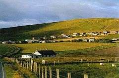 The village of Veensgarth, nestling under Herrislee hill. Seen looking north-east. |
|
 Veensgarth |
|
| OS grid reference | HU427444 |
|---|---|
| Civil parish | Tingwall |
| Council area | Shetland |
| Lieutenancy area | Shetland |
| Country | Scotland |
| Sovereign state | United Kingdom |
| Post town | SHETLAND |
| Postcode district | ZE2 |
| Dialling code | 01595 |
| Police | Scottish |
| Fire | Scottish |
| Ambulance | Scottish |
| EU Parliament | Scotland |
| UK Parliament | Orkney and Shetland |
| Scottish Parliament | Shetland |
Coordinates: 60°10′59″N 1°13′44″W / 60.183°N 1.229°W
Veensgarth (Old Norse: Vikingsgarðr, Viking farm, or Vingarðr, Meadow Farm), is a village in the Tingwall valley west of Lerwick in Shetland. It includes the Vallafield housing estate. Veensgarth is also within the parish of Tingwall,[1] and is situated at the junction of the A970 and the B9074.[2]
References
- ↑ "Details of Veensgarth". Gazetteer for Scotland. Retrieved 2 January 2015.
- ↑ "B9074". Sabre. Retrieved 2 January 2015.
External links
| Wikimedia Commons has media related to Veensgarth. |
This article is issued from Wikipedia - version of the 1/2/2015. The text is available under the Creative Commons Attribution/Share Alike but additional terms may apply for the media files.