Urbiztondo, Pangasinan
| Urbiztondo.png | ||
|---|---|---|
| Municipality | ||
|
| ||
| ||
| Motto: Urbiztondo Numero Uno! | ||
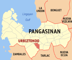
 Map of Pangasinan showing the location of Urbiztondo | ||
.svg.png) Urbiztondo.png Location within the Philippines | ||
| Coordinates: 15°49′N 120°21′E / 15.817°N 120.350°ECoordinates: 15°49′N 120°21′E / 15.817°N 120.350°E | ||
| Country | Philippines | |
| Region | Ilocos (Region I) | |
| Province | Pangasinan | |
| District | 2nd district of Pangasinan | |
| Barangays | 21 | |
| Government[1] | ||
| • Mayor: Martin Raul S. Sison II | Vice Mayor: Marilyn S. Sison | |
| Area[2] | ||
| • Total | 81.80 km2 (31.58 sq mi) | |
| Population (2016)[3] | ||
| • Total | 53,203 | |
| • Density | 650/km2 (1,700/sq mi) | |
| Time zone | PST (UTC+8) | |
| ZIP code | 2414 | |
| Dialing code | 75 | |
| Income class | 3rd class; rural | |
| Website | http://urbiztondopang.gov.ph/ | |
Urbiztondo is a third class municipality in the province of Pangasinan, Philippines. According to the 2010 census, it has a population of 47,831 people.[3] The municipality was named after Spanish governor-general General Antonio de Urbiztondo y Villasis who acted as Spanish Governor in the Philippines and was also conqueror of the Muslims in Jolo from 1850 to 1852. He then issued a decree founding the town and consequently the newly formed town was named “Urbiztondo” in his honor. The Municipality of Urbiztondo’s establishment as a town was primarily due to Fr. Ramon Dalmau, the parish priest of San Carlos, who began its foundation in 1852, separating the said town from San Carlos now a city. The initiative in the emergence of Urbiztondo came from the pioneering fathers from San Carlos, Pangasinan. Its creation has been credited to Rev. Father Ramon Dalmau, curate of San Carlos who worked hard for its founding on November 28, 1853. It remained a visita of San Carlos in the year 1852. It was separated from San Carlos on the above date when it was assigned its own curate. The Dominicans accepted Urbiztondo as a vicariate in 1855 designating Rev. Father Francisco Treserra who is also responsible for relocating the town to the place where it is now located.
Barangays
Urbiztondo is politically subdivided into 21 barangays.[2]
- Angatel
- Balangay
- Batangcaoa
- Baug
- Bayaoas
- Bituag
- Camambugan
- Dalanguiring
- Duplac
- Galarin
- Gueteb
- Malaca
- Malayo
- Malibong
- Pasibi East
- Pasibi West
- Pisuac
- Poblacion
- Real
- Salavante
- Sawat
Demographics
| Population census of Urbiztondo | ||
|---|---|---|
| Year | Pop. | ±% p.a. |
| 1990 | 33,102 | — |
| 1995 | 35,746 | +1.45% |
| 2000 | 40,089 | +2.49% |
| 2007 | 43,430 | +1.11% |
| 2010 | 47,831 | +3.58% |
| 2015 | 50,170 | +0.91% |
| Source: National Statistics Office[3][4] | ||
Climate
| Climate data for Urbiztondo, Pangasinan | |||||||||||||
|---|---|---|---|---|---|---|---|---|---|---|---|---|---|
| Month | Jan | Feb | Mar | Apr | May | Jun | Jul | Aug | Sep | Oct | Nov | Dec | Year |
| Average high °C (°F) | 31 (88) |
32 (90) |
33 (91) |
34 (93) |
33 (91) |
32 (90) |
31 (88) |
30 (86) |
31 (88) |
32 (90) |
32 (90) |
31 (88) |
31.8 (89.4) |
| Average low °C (°F) | 22 (72) |
23 (73) |
24 (75) |
25 (77) |
25 (77) |
25 (77) |
25 (77) |
25 (77) |
25 (77) |
24 (75) |
24 (75) |
23 (73) |
24.2 (75.4) |
| Average precipitation mm (inches) | 9 (0.35) |
11.4 (0.449) |
11.1 (0.437) |
5.4 (0.213) |
258 (10.16) |
315.6 (12.425) |
463.1 (18.232) |
663.2 (26.11) |
479.7 (18.886) |
121.9 (4.799) |
75.8 (2.984) |
16.8 (0.661) |
2,431 (95.706) |
| Average rainy days | 4 | 3 | 2 | 2 | 12 | 15 | 19 | 21 | 18 | 12 | 9 | 5 | 122 |
| Source: World Weather Online[5] | |||||||||||||
References
- ↑ "Official City/Municipal 2013 Election Results". Intramuros, Manila, Philippines: Commission on Elections (COMELEC). 1 July 2013. Retrieved 9 September 2013.
- 1 2 "Province: PANGASINAN". PSGC Interactive. Makati City, Philippines: National Statistical Coordination Board. Retrieved 26 November 2012.
- 1 2 3 "Total Population by Province, City, Municipality and Barangay: as of May 1, 2010" (PDF). 2010 Census of Population and Housing. National Statistics Office. Retrieved 26 November 2012.
- ↑ "Province of Pangasinan". Municipality Population Data. LWUA Research Division. Retrieved 9 September 2013.
- ↑ "Urbiztondo, Pangasinan: Average Temperatures and Rainfall". World Weather Online. Retrieved 31 October 2015.
External links
| Wikimedia Commons has media related to Urbiztondo, Pangasinan. |
- Philippine Standard Geographic Code
- Philippine Census Information
- Local Governance Performance Management System
 |
San Carlos | Basista |  | |
| Mangatarem | |
Bayambang | ||
| ||||
| | ||||
| Mangatarem |
