Ujar District

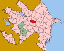
Ujar Rayon (Ucar Rayonu[1]) is a rayon (administrative district) of Azerbaijan, situated to the south of Goycay, in the centre of the country. This region contains the Baku-Tbilisi-Ceyhan pipeline to the south of the Shirvan plain. There are 32 villages and 1 city in Ucar. The largest communities are Qazyan, Müsüslü and Qarabörk.
As of 2009, Ujar Rayon had an estimated population of 77,900 people, of which 22% were urban dwellers and 78% rural.[2] The population is 99.7% Azerbaijanis.
History
The name Ucar derives from the Turkic word "Ucqar" meaning "remote", as Ucar was remote from the Shirvanshah capital at Baku, and on the frontier of the Shirvan state.[3]
The Ujar Rayon was created on 24 January 1939 as an independent administrative unit from part of Goychay region.[4]
Administration
Chief executives
- Gyulyushov, Nariman oglu Ibish - from 1994(?) to 29 March 2005
- Gafurov, Arzu Telman oglu - from 29 March 2005 to 5 April 2010[5]
- Mamedov, Yashar oglu Qahraman - since 5 April 2010[6]
Municipalities
Ujar Rayon is divided into twenty-nine municipalities.
- Ujar Municipality is coëxtensive with the city of Ucar
- Məlikballı Municipality
- Müsüslü Municipality
- Qarabörk Municipality
- Qazyan Municipality
Notes
- ↑ "Ucar Rayonu (Approved)" Ujar District at GEOnet Names Server, United States National Geospatial-Intelligence Agency
- ↑ "Demographic indicators" The State Statistical Committee of the Republic of Azerbaijan
- ↑ Eminov, Zakir Namin oğlu (2005) Azärbaycanın ähalisi: iqtisadi, sosial vä demoqrafik problemlär Baku, page 157, OCLC 254902980, in Azeri
- ↑ "Ujar Rayon" Supreme Court of Azerbaijan, in Russian, last accessed 12 November 2010
- ↑ "Ильхам Алиев подписал распоряжение о снятии Арзу Тельман оглу Гафурова с должности главы Исполнительной власти Уджарского района ("Ilham Aliyev signed a decree withdrawing Arzu Telman oglu Gafurova from the office of the chief executive of the Ujar region"" (in Russian). "The First News". 5 April 2010.
- ↑ "Ильхам Алиев подписал распоряжение о назначении Яшара Гахраман оглу Мамедова главой Исполнительной власти Уджарского района ("Ilham Aliyev signed a decree on the appointment of Yashar oglu Mammadov Qahraman chief executive of the Ujar region")" (in Russian). "The First News". 5 April 2010., archived at FreezePage
| Part of the series on |
| Azerbaijan Azərbaycan |
|---|
  |
| Culture |
| History |
| Demographics |
| Geography |
| Administrative divisions |
| Azerbaijan portal |
Coordinates: 40°30′N 47°39′E / 40.500°N 47.650°E
.svg.png)