Truro
| Truro | |
| Cornish: Truru | |
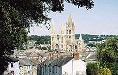 Truro Cathedral, as seen here dominates the city. |
|
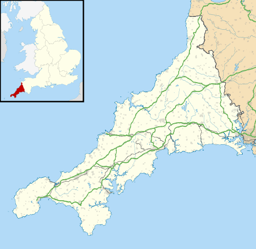 Truro |
|
| Population | 18,766 [1] |
|---|---|
| OS grid reference | SW825448 |
| – London | 232 miles (373 km) ENE |
| Civil parish | Truro |
| Unitary authority | Cornwall |
| Ceremonial county | Cornwall |
| Region | South West |
| Country | England |
| Sovereign state | United Kingdom |
| Post town | TRURO |
| Postcode district | TR1-4 |
| Dialling code | 01872 |
| Police | Devon and Cornwall |
| Fire | Cornwall |
| Ambulance | South Western |
| EU Parliament | South West England |
| UK Parliament | Truro and Falmouth |
| Website | truro.gov.uk |
Coordinates: 50°15′36″N 5°03′04″W / 50.260°N 5.051°W
Truro (/ˈtrʊəroʊ/; Cornish: Truru)[2] is a city and civil parish in Cornwall, England, United Kingdom. Truro is Cornwall's county town and only city, its centre for administration, leisure and retail and had a population recorded in the 2011 census of 18,766.[1] It is the most southern city in mainland Great Britain. People from Truro are known as Truronians.
Truro grew as a centre of trade from its port and then as a stannary town for the tin mining industry. The city's cathedral was completed in 1910. Places of interest include the Royal Cornwall Museum, the Hall for Cornwall and Cornwall's Courts of Justice.
Toponymy
The origin of Truro's name is debated. It is said to be derived from the Cornish tri-veru meaning "three rivers", but references such as the Oxford Dictionary of English Place Names reject this theory. The "tru" part might mean "three", though this is doubtful. An expert on Cornish place-names, Oliver Padel, in his book A Popular Dictionary of Cornish Place-names, wrote that the 'three rivers' meaning is "possible".[3] Alternatively the name may derive from *tre-uro or similar, i.e. the settlement on the river *uro.[4][5]
History
The earliest records and archaeological findings of a permanent settlement in the Truro area originate from Norman times. A castle was built in the 12th century by Richard de Luci, Chief Justice of England in the reign of Henry II, who for his services to the court was granted land in Cornwall, including the area surrounding the confluence of the two rivers. The town grew in the shadow of the castle and was awarded borough status to further economic activity. The castle has long since gone.
Richard de Lucy fought in Cornwall under Count Alan of Brittany after leaving Falaise late in 1138. The small adulterine castle at Truro, Cornwall (originally the parish of Kenwyn), later known as “Castellum de Guelon” was probably built by him between 1139-1140. He styled himself "Richard de Lucy, de Trivereu". The castle later passed to Reginald FitzRoy (also known as Reginald de Dunstanville), an illegitimate son of Henry I, when he was invested by King Stephen as the first Earl of Cornwall. Reginald married Mabel FitzRichard, daughter of William FitzRichard, a substantial landholder in Cornwall. The 75-foot (23 m) diameter castle was in ruins by 1270 and the motte levelled in 1840. It is today the site of the Crown Court. Reginald FitzRoy confirmed c1170 in a charter to the burgesses of Truro the privileges which had been granted by Richard de Lucy. Richard held ten Knights Fees in Cornwall prior to 1135 and at his death a third of his considerable total holding remained in Cornwall.[6]
By the start of the 14th century Truro was an important port, due to its inland location away from invaders, prosperity from the fishing industry, and its new role as one of Cornwall's stannary towns for assaying and stamping tin and copper from Cornish mines. The Black Death arrived, and with it a trade recession, resulting in a mass exodus of the population; and the town was left in a very neglected state.
Trade gradually returned and the town became prosperous during the Tudor period. Self-governance was awarded in 1589 when a new charter was granted by Elizabeth I, which gave Truro an elected mayor and control over the port of Falmouth.
During the Civil War in the 17th century, Truro raised a sizeable force to fight for the king and a royalist mint was set up. Defeat by the Parliamentary troops came in 1646 and the mint was moved to Exeter. Later in the century Falmouth was awarded its own charter giving it rights to its harbour, starting a long rivalry between the two towns. The dispute was settled in 1709 with control of the River Fal divided between Truro and Falmouth. The arms of the city of Truro are "Gules the base wavy of six Argent and Azure, thereon an ancient ship of three masts under sail, on each topmast a banner of St George, on the waves in base two fishes of the second".[7]

Truro prospered greatly during the 18th and 19th centuries. Industry flourished thanks to improved mining methods and higher prices for tin, and the town attracted wealthy mine owners. Elegant Georgian and Victorian townhouses were built, such as those seen today on Lemon Street, named after the mining magnate and local MP Sir William Lemon; Truro became the centre for high society in the county, being mentioned as "the London of Cornwall".[8]

Throughout those prosperous times Truro remained a social centre, and many notable people hailed from it. One of the most noteworthy residents was Richard Lander, an explorer who discovered the mouth of the River Niger in Africa and was awarded the first gold medal of the Royal Geographical Society. Henry Martyn read mathematics at Cambridge, was ordained and became a missionary, translating the New Testament into Urdu and Persian. Others include Humphry Davy, educated in Truro and the inventor of the miner's safety lamp, and Samuel Foote, an actor and playwright from Boscawen Street.
Truro's importance increased later in the 19th century and it had its own iron smelting works, potteries, and tanneries. The Great Western Railway arrived in Truro in the 1860s with a direct line from London Paddington, and the Bishopric of Truro Act 1876 which gave the town a bishop, then a cathedral. The next year Queen Victoria granted Truro city status.
The start of the 20th century saw a decline of the mining industry; however the city remained prosperous as instead of its previous role as a market town Truro became the administrative and commercial centre of Cornwall, and saw substantial development. Today, Truro is still the retail centre of Cornwall but, like many other cities, faces concerns over the replacement of many of its renowned speciality shops by national chain stores, the erosion of its identity, and also over how to accommodate expected growth in the 21st century.
Geography

Truro is located in the centre of western Cornwall, about 9 miles (14 kilometres) from the south coast on the confluence of the rivers Kenwyn and Allen, which combine to become the Truro River, one of a series of creeks, rivers and drowned valleys leading into the River Fal and then to the large natural harbour of Carrick Roads. The river valleys form a bowl surrounding the city on the north, east and west and open to the Truro River in the south. The fairly steep-sided bowl in which Truro is located, along with high precipitation swelling the rivers and a spring tide in the River Fal, were major factors in the 1988 floods which seriously damaged the city centre. Since then, flood defences have been constructed around the city, including an emergency dam at New Mill on the River Kenwyn and a tidal barrier on the Truro River.
The city is surrounded by a number of protected natural areas such as the historic parklands at Pencalenick, and larger areas of ornamental landscape, such as Trelissick Garden and Tregothnan further down the Truro River. An area south-east of the city, around and including Calenick Creek, has been designated an Area of Outstanding Natural Beauty. Other protected areas include an Area of Great Landscape Value comprising agricultural land and wooded valleys to the north east, and Daubuz Moors, a Local Nature Reserve alongside the River Allen close to the city centre.
Truro has mainly grown and developed around the historic city centre in a nucleated fashion along the slopes of the bowl valley, except for fast linear development along the A390 to the west, towards Threemilestone. As Truro has grown, it has incorporated a number of other settlements as suburbs or unofficial districts. These include Kenwyn and Moresk to the north, Trelander to the east, Newham to the south, and Highertown, Treliske and Gloweth to the west.
Demography and economy
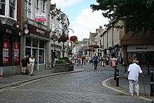
Truro urban statistical area, which includes parts of surrounding parishes, had a 2001 census population of 20,920.[9] By 2011 the population including Threemilestone was 23,040. Truro's status as the county's number one destination for retail and leisure, and its role as the administrative centre of the county, is unusual as it is only the fourth most populous settlement in Cornwall.[9] Furthermore, population growth has been slow compared to other Cornish towns and Cornwall as a whole, at 10.5% from 1971 to 1998.
Major employers in the city include the Royal Cornwall Hospital, Cornwall Council, and Truro College. There are about 22,000 jobs available in Truro, compared to only 9,500 economically active people living in the city. So many local workers commute into Truro: a major factor in the city's traffic congestion problems. Average earnings are higher than the rest of Cornwall.
Housing prices in Truro are at an all-time high, and are 8% higher than the rest of Cornwall. Truro was named in 2006 as the top small city in the United Kingdom for increasing house prices, at 262% since 1996.[10] There is a heavy demand for new housing in the city, and a call for inner city properties to be converted into flats or houses to encourage city centre living and to reduce the dependence on cars.
Culture
Attractions
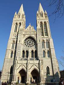
Truro's most recognisable feature is its Gothic-revival Cathedral, designed by architect John Loughborough Pearson and rising 76 m (249 ft) above the city at its highest spire.[11] It took 30 years to build, from 1880 to 1910, and was built on the site of the old St. Mary's Church, consecrated over 600 years earlier. Enthusiasts of Georgian architecture are well catered for in the city, with terraces and townhouses along Walsingham Place and Lemon Street often said to be "the finest examples of Georgian architecture west of the city of Bath".[12]
The main attraction for local residents in the region is the wide variety of shops. Truro has various chain stores, speciality shops and markets, which reflect its historic tradition as a market town. The indoor Pannier Market is open year-round with many stalls and small businesses. The city is also popular for its eateries, including cafés and bistros. Additionally, it has emerged as a popular destination for nightlife with many bars, clubs and restaurants opening. Truro is also known for the Hall for Cornwall, a performing arts and entertainment venue.
The Royal Cornwall Museum is the oldest and premier museum in Cornwall for exhibitions detailing Cornish history and culture, with a wide range of collections such as archaeology, art and geology. Among the exhibits of the museum there is the so-called Arthur's inscribed stone. Truro is also noted for its parks and open spaces, including Victoria Gardens, Boscawen Park and Daubuz Moors.
Events

Lemon Quay is the centre of most festivities in Truro, which attracts visitors year-round with numerous different events.
In April, Truro prepares to partake in the Britain in Bloom competition, with many floral displays and hanging baskets dotted around the city throughout the summer. A "continental market" also comes to Truro during the season and features food and craft stalls from all over Europe including France, Spain, Italy, Germany, Belgium, the Netherlands and Greece.
Cornwall Pride, a Pride event which celebrates diversity and the LGBT community, takes place on the last Saturday of every August.
The Truro City Carnival takes place every September over a weekend, including various arts and music performances, children's activities, a fireworks display, food and drinks fairs, a circus, and a parade. A half-marathon also takes place in September, organised by Truro Running Club, with hundreds of participants running from the city centre into the countryside towards Kea, returning to finish at Lemon Quay.
Truro celebrates the Christmas season with its Winter Festival, which includes a paper lantern parade known as the City of Lights Procession. Many local primary schools as well as colleges and community and youth groups join in the procession. Students at the local college in Truro have created large lanterns, complementing the work of the core artists team. There are Christmas lights throughout the city centre, as well a "big switch-on" event, speciality products and crafts fairs, late-night shopping evenings, various events at the Cathedral and a fireworks display on New Year's Eve. A Christmas tree is put up on the Piazza, and another outside the Cathedral at High Cross. A badly executed fundraising operation left the city with underwhelming decorations in 2005, but the 2006 Festival was much more successful: it featured extensive festivities and decoration including an artificial ski slope constructed on Lemon Quay.
Sports
Truro was temporarily the home to rugby union club Cornish Pirates, but the team is now back at its historical base in Penzance. Discussions are currently in progress about the possible construction of a Stadium for Cornwall, planned for Threemilestone.[13] The city is also home to Truro City F.C., a football team in the National League South, the only Cornish club ever to reach this tier of the football pyramid. The club achieved national recognition when they won the FA Vase in 2007, beating A.F.C. Totton 3–1 in only the second ever final at the new Wembley Stadium, and becoming the first Cornish side ever to win the FA Vase. Cornwall County Cricket Club play some of their home fixtures at Boscawen Park, which is also the home ground of Truro Cricket Club. Truro Fencing Club is one of Britain's flagship fencing clubs, having won numerous national championships, and had three fencers selected for Team GB at the London 2012 Olympics. Other sporting amenities include a leisure centre, golf course, and tennis courts.
Media
Truro is the centre of Cornwall's local media. The county-wide weekly newspapers, The West Briton and the Cornish Guardian, are based in the city and serves the Truro area with its Truro and Mid-Cornwall edition. The city is also home to the broadcasting studios of BBC Radio Cornwall, and the studios of the West district of ITV Westcountry, whose main studio is now located in Bristol after ITV Westcountry merged with ITV West, the studio in Plymouth was closed and Westcountry Live was replaced by The West Country Tonight.
Customs
A mummers play text which had, until recently, been attributed to Mylor, Cornwall (much quoted in early studies of folk plays, such as The Mummers Play by R. J. E. Tiddy – published posthumously in 1923 – and The English Folk-Play (1933) by E. K. Chambers), has now been shown, by genealogical and other research, to have originated in Truro, Cornwall, around 1780.[14][15]
Climate
The Truro area has an oceanic climate similar to the remainder of Cornwall. The climate in the area sees even fewer extremes in temperature than the remainder of England and is marked by high rainfall, cool summers, mild winters and frosts being very rare.
| Climate data for Truro Camborne, elevation: 87 m or 285 ft (1981-2010) extremes (1979-present) | |||||||||||||
|---|---|---|---|---|---|---|---|---|---|---|---|---|---|
| Month | Jan | Feb | Mar | Apr | May | Jun | Jul | Aug | Sep | Oct | Nov | Dec | Year |
| Record high °C (°F) | 15.5 (59.9) |
14.2 (57.6) |
18.0 (64.4) |
21.8 (71.2) |
24.5 (76.1) |
26.2 (79.2) |
29.3 (84.7) |
29.4 (84.9) |
26.0 (78.8) |
22.3 (72.1) |
17.0 (62.6) |
15.3 (59.5) |
29.4 (84.9) |
| Average high °C (°F) | 8.9 (48) |
8.7 (47.7) |
10.1 (50.2) |
11.7 (53.1) |
14.3 (57.7) |
16.7 (62.1) |
18.6 (65.5) |
19.0 (66.2) |
17.3 (63.1) |
14.3 (57.7) |
11.5 (52.7) |
9.6 (49.3) |
13.4 (56.1) |
| Daily mean °C (°F) | 6.8 (44.2) |
6.5 (43.7) |
7.8 (46) |
8.9 (48) |
11.5 (52.7) |
13.8 (56.8) |
15.8 (60.4) |
16.1 (61) |
14.6 (58.3) |
12.0 (53.6) |
9.3 (48.7) |
7.4 (45.3) |
10.9 (51.6) |
| Average low °C (°F) | 4.6 (40.3) |
4.2 (39.6) |
5.4 (41.7) |
6.1 (43) |
8.6 (47.5) |
10.9 (51.6) |
13.0 (55.4) |
13.2 (55.8) |
11.8 (53.2) |
9.6 (49.3) |
7.1 (44.8) |
5.2 (41.4) |
8.3 (46.9) |
| Record low °C (°F) | −9.4 (15.1) |
−6.8 (19.8) |
−3.2 (26.2) |
−1.3 (29.7) |
0.3 (32.5) |
4.8 (40.6) |
7.2 (45) |
7.4 (45.3) |
4.8 (40.6) |
−0.3 (31.5) |
−3.8 (25.2) |
−4.7 (23.5) |
−9.4 (15.1) |
| Average precipitation mm (inches) | 121.4 (4.78) |
88.2 (3.472) |
79.4 (3.126) |
73.6 (2.898) |
65.0 (2.559) |
58.2 (2.291) |
67.4 (2.654) |
68.3 (2.689) |
77.3 (3.043) |
114.9 (4.524) |
123.8 (4.874) |
123.9 (4.878) |
1,061.3 (41.783) |
| Average precipitation days (≥ 1.0 mm) | 16.4 | 12.7 | 12.5 | 11.7 | 10.4 | 8.6 | 9.8 | 10.3 | 11.0 | 15.7 | 16.3 | 15.8 | 151.2 |
| Mean monthly sunshine hours | 60.5 | 81.7 | 118.4 | 184.6 | 214.6 | 211.2 | 198.2 | 194.8 | 157.5 | 109.7 | 74.5 | 59.2 | 1,664.9 |
| Source #1: Met Office[16] | |||||||||||||
| Source #2: KNMI[17] | |||||||||||||
Administration
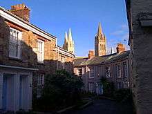
Truro City Council, a City/Parish Council, is based upstairs at the Municipal Buildings in Boscawen Street, and is responsible for parks, gardens and planting, mayoral and civic events, support of its overseas twinning, and tourist information. It also considers Planning issues and has been crucially involved in creating the Truro and Kenwyn Neighbourhood Plan in association with Cornwall Council. The city is divided into four wards: Boscawen, Moresk, Tregolls and Trehaverne, with 24 councillors elected for four-year terms.[18] Cornwall Council (a unitary authority) has its base at Lys Kernow ("Cornwall Court", formerly County Hall) west of the city centre. It administers planning, infrastructure, development and environmental issues, and the parish council liaises with it.
Twinning
Truro is twinned with Boppard, in the Rhineland-Palatinate region of Germany, and Morlaix in Brittany, France, after which Morlaix Avenue in Truro is named.[19]
The town of Truro in the Province of Nova Scotia, Canada is named after Truro, as is the town of Truro in the US state of Massachusetts.
Transport
Roads and bus services
Truro is 6 miles (9.7 km) from the A30 trunk road, to which it is connected by the A39 leading from Falmouth and Penryn. Also passing through the city is the A390, from Redruth in the west to Liskeard in the east where it connects to the A38, which then goes on to Plymouth and further to Exeter and the M5 motorway. Truro is the most southerly city in the United Kingdom, just under 232 miles (373 km) west south west of Charing Cross, London.
The city and surrounding area are served by extensive bus services, with routes in and out of the city in all directions, mostly starting and terminating at Truro Bus Station near Lemon Quay. A permanent Park and Ride scheme, known as Park for Truro, began operation in August 2008. Based at Langarth Park in Threemilestone, buses carry commuters into the city centre via Truro College, the Royal Cornwall Hospital Treliske, County Hall, Truro railway station, the Royal Cornwall Museum and Victoria Square, and now through to a second car park on the east side of Truro. Longer-distance coaches run by National Express also operate from Truro.
Railways

Truro railway station is about 1 km (0.6 mi) from the city centre and is on the Cornish Main Line, giving the city a direct connection to London Paddington, as well as to the Midlands, North and Scotland. North-east of the station is a 28-metre-high (92-foot) stone viaduct with expansive views over the city, cathedral, and Truro River in the distance. The viaduct—the longest on the line—replaced Isambard Kingdom Brunel's wooden Carvedras Viaduct in 1904. Connecting to the main line at Truro station is the Maritime Line, a branch line to Falmouth in the south.
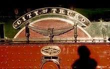
Truro's first railway station was at Highertown, which was opened in 1852 by the West Cornwall Railway and from where trains ran to Redruth and Penzance. It was known as Truro Road Station; it was just west of Highertown Tunnel on the up side. The line was extended to the Truro River at Newham in 1855 Then Truro Road Station closed and Newham served as the terminus. When the Cornwall Railway connected the line to Plymouth, their trains ran to the present station above the city centre. The West Cornwall Railway (WCR) then diverted most of its passenger trains to the new station, leaving Newham mainly as a goods station until it closed in 1971. The WCR became part of the Great Western Railway. The route from Highertown to Newham is now a cycle path which takes a leisurely loop through the countryside on the south side of the city. The steam locomotive, the City of Truro, was built in 1903 and still runs on UK mainline and preserved railways..
Air and river transport
Newquay Airport is Cornwall's main airport and is 12 mi (19 km) north of Truro. One of the fastest-growing regional airports in the UK, the services and destinations are constantly expanding. There are regular flights to and from London Gatwick and other cities around the country, the Isles of Scilly and Düsseldorf in Germany.
There is also a boat link to Falmouth along the Rivers Truro and Fal, four times daily, tide permitting. The small fleet run by Enterprise Boats and part of the Fal River Links also stops at Malpas, Trelissick, Tolverne and St Mawes.
Churches
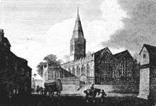


The old parish church of Truro was St Mary's, incorporated into the cathedral in the later 19th century. Parts of the town were in the parishes of Kenwyn and St Clement (Moresk) until the mid 19th century when other parishes were created. St George's church in Truro, designed by the Reverend William Haslam, vicar of Baldhu, was built of Cornish granite in 1855; it is lofty and imposing. The parish of St George's Truro was formed from part of Kenwyn in 1846. In 1865 two more parishes were created: St John's from part of Kenwyn and St Paul's from part of St Clement.[20][21] St George's contains a large wall painting behind the high altar which was the work of Stephany Cooper in the 1920s. Her father Canon Cooper had been a missionary in Zanzibar and elsewhere. The theme of the mural painting is "Three Heavens": the first heaven has views of Zanzibar and its cathedral (a happy period in the life of the artist); the second heaven has views of the city of Truro including the cathedral, the railway viaduct and St George's church (another happy period in the life of the artist); the third heaven is above the others which are separated from it by the River of Life (Christ is represented bridging the river and 17 saints including St Piran and St Kenwyn are depicted in this part).[22]
Charles William Hempel was organist of St. Mary's Church for forty years from 1804, supplementing his income by teaching music. In 1805 he composed and printed Psalms from the New Version for the use of the Congregation of St. Mary's, and in 1812 Sacred Melodies for the same congregation. These melodies became very popular.
The oldest church in Truro is at Kenwyn, on the northern side of the city. It is of 14th/15th century date.
St John's Church (dedicated to St John the Evangelist) was built in 1828 (architect P. Sambell) in the Classical style on a rectangular plan and with a gallery. Considerable alterations were carried out in the 1890s.
St Paul's Church was built in 1848. The chancel was replaced in 1882–84, the new chancel being the work of J. D. Sedding. The tower is "broad and strong" (Pevsner) and the exterior of the aisles are ornamented in Sedding's version of the Perpendicular style.[23] In the parish of St Paul is the former Convent of the Epiphany (Anglican) at Alverton House, Tregolls Road, an early 19th-century house. The house was extended for the convent of the Community of the Epiphany and the chapel was built in 1910 by Edmund H. Sedding.[23] The sisterhood was founded by the Bishop of Truro, George Howard Wilkinson, in 1883 and closed in 2001 when the two surviving nuns moved into care homes. The sisters were involved in pastoral and educational work and the care of the cathedral and St Paul's Church.[24] St Paul's Church, built with a tower on a river bed with poor foundations, has fallen into disrepair, and is no longer in use. Services are now held at the churches of St Clement, St George, and St John. St Paul & St Clement is now a united benefice as is St George and St John.
There is a Quaker Meeting House built in granite (ca. 1830) and among the Methodist chapels (and the only one still in use for its original purpose) is that in Union Place which has a broad granite front (1830, but since enlarged). There are numerous other churches, some meeting in their own modern buildings (St Piran's Catholic, All Saints Highertown) and some in schools or halls. The Baptist church building occupies the site of the former Lake's pottery, one of the oldest in Cornwall.
Education
Educational institutions in Truro include:
- Archbishop Benson – A Church Of England Voluntary Aided Primary School
- Polwhele House Preparatory School — now educates the choristers from the former Truro Cathedral School
- Truro School — a public school founded in 1880.
- Truro High School for Girls — a female-only public school, for ages 13–18.
- Penair School — a state school, co-educational science college, for children aged 11–16.
- Richard Lander School — a state school, co-educational technology college, for children aged 11–16.
- Truro College — A further and higher education college. Part of the Combined Universities in Cornwall.
- University of Exeter Medical School[25]
The former Truro Girls Grammar School was converted into a Sainsbury's supermarket.[26]
Development

Truro has many proposed development schemes and plans, the majority of which are intended to counter the main problems it faces, notably traffic congestion and lack of housing.
Major proposals include the construction of a distributor road to carry traffic away from the very busy Threemilestone-Treliske-Highertown corridor, reconnecting at either Green Lane or Morlaix Avenue. This road will also serve the new housing planned for that area.[27]
As of 2008 major changes are also proposed for the city centre, such as pedestrianisation of the main shopping streets and beautification of a list of uncharacteristic storefronts built in the 1960s.[27] Also, new retail developments on the current Carrick District Council site and Garras Wharf waterfront site will provide more space for shops, open spaces and public amenities and also turn rather ugly areas of the city into attractive new destinations.[27] Along with the redevelopment of the waterfront, a tidal barrier is planned to dam water into the Truro River which is currently blighted by unsightly mud banks which appear at low tide.[27]
Controversial developments include the construction of a new stadium for Truro City F.C. and the Cornish Pirates, and the relocation of the city's golf course to make way for more housing. A smaller project is the addition of two large sculptures in the Piazza.[28]
Notable residents

- 16th century
- Giles Farnaby — a madrigalist of the Elizabethan age.
- Owen Fitzpen — a philanthropist, born in the Elizabethan age, who earned his fortune, first as a merchant seaman and his fame in leading a successful slave revolt in 1627 to free himself and other captives of Barbary pirates.
- 18th century
- Edward Boscawen — an admiral of the Royal Navy. A cobbled street at the centre of Truro and a park are named in his honour.
- Samuel Foote — an actor and playwright.
- 18th/19th century
- John Vivian — later became an influential industrialist in Swansea (see Vivian family)
- Henry Martyn — Cambridge mathematician, missionary in India and Persia, translated the Bible into local languages.
- 19th century
- Charles Foster Barham — physician and writer on public health
- Henry Charlton Bastian — physiologist and neurologist
- Charles Chorley — journalist and man of letters
- Joseph Antonio Emidy — a former slave turned violinist.
- James Henry Fynn sometimes James Henry Finn — a recipient of the Victoria Cross.
- Charles William Hempel — organist of St Mary's Church
- Richard Lemon Lander — an explorer of West Africa. A local secondary school is named in his honour and a monument to his memory stands at the top of Lemon Street.
- Richard Spurr — a cabinet maker and lay preacher who was imprisoned for his part in leading the political movement Chartism. A large allotment in the town was dedicated to his memory in 2011.
- Silvanus Trevail — local architect and Mayor of Truro.[29]

- 20th century
- Matthew Etherington — a professional footballer playing for Stoke City.
- Henry Louis Gibson — an expert in medical uses of infrared and pioneer of its use in detecting breast cancer.
- Robert Goddard — novelist.
- Joseph Hunkin — bishop of Truro[30]
- Maria Kuncewiczowa — a famous Polish writer who lived in Truro after WWII. Her novel, Tristan 1946, takes place there.
- James Marsh — film director and winner of an Academy Award.
- Nick Nieland — a Commonwealth Games javelin gold medallist.
- Ben Salfield — international concert performer, composer and promoter, lives on the edge of the city.
- Roger Meddows Taylor — drummer from the rock band Queen
- Joanna Thomas — professional female bodybuilder.
- Tom Voyce — a former London Wasps and England rugby union footballer who now plays at wing or fullback for Gloucester RFC.
- Hugh Walpole — novelist.
- Barbara Joyce West — second to last survivor of the RMS Titanic.
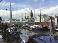
.
See also
References
- 1 2 Office for National Statistics 2011 census - Truro CP
- ↑ "List of Place-names agreed by the MAGA Signage Panel" (PDF). Cornish Language Partnership. May 2014. Retrieved 2015-01-11.
- ↑ Padel, O. J. (1988) A Popular Dictionary of Cornish Place-names, Penzance, A. Hodge ISBN 0-906720-15-X
- ↑ Parochial history of Cornwall, Davis Gilbert
- ↑ patronymica Cornu-Britannica
- ↑ de Lucy in the 12th Century, Norman Lucey 2009 lucey.net/webpage62.htm
- ↑ Pascoe, W. H. (1979). A Cornish Armory. Padstow, Cornwall: Lodenek Press. p. 135. ISBN 0-902899-76-7.
- ↑ "History of Truro". Truro Town Site. Retrieved 13 January 2008.
- 1 2 "Census 2001 Key Statistics for urban areas in England and Wales" (PDF). National Office of Statistics. Retrieved 13 January 2008.
- ↑ "Homes in smaller cities cost more". BBC News. 20 May 2006. Retrieved 13 January 2008.
- ↑ "Building Statistics – Truro Cathedral, Truro". Emporis. Retrieved 13 January 2008.
- ↑ "Daytripper – Sheer Indulgence in Truro". Truro City Council. Archived from the original on 7 October 2007. Retrieved 13 January 2008.
- ↑ "Renewed hope for sports stadium". BBC News. 21 December 2007. Retrieved 13 January 2008.
- ↑ "FindArticles.com - CBSi". Retrieved 13 November 2016.
- ↑ "Truro [Formerly Mylor]: "A Play for Christmas", 1780s". folkplay.info.
- ↑ "Nottingham 1981–2010 averages". Met Office. Retrieved 4 November 2012.
- ↑ "Nottingham extreme values". KNMI. Retrieved 8 November 2011.
- ↑ "Councillors & Wards". Truro City Council. Archived from the original on 28 September 2007. Retrieved 13 January 2008.
- ↑ "Aims of Twinning". Truro-Morlaix Twinning Association. Retrieved 10 May 2010.
- ↑ Cornish Church Guide (1925) Truro: Blackford; pp. 210–11
- ↑ "Parishes of St Paul, Truro, St Clement, St George, Truro, and St John, Truro (united benefice)". Truro Churches (official). Retrieved 15 December 2009.
- ↑ Rendell, Joan (1982) Cornish Churches. St Teath: Bossiney Books; pp. 38–39
- 1 2 Pevsner, N. (1970) Cornwall; 2nd ed. Penguin Books; pp. 234–35
- ↑ Cornish Church Guide. Truro: Blackford; pp. 325–26
- ↑ "University of Exeter". Retrieved 13 November 2016.
- ↑ "Grammar 'girls' share memories of schooldays". West Briton.
- 1 2 3 4 "Truro and Threemilestone Action Plan". Carrick District Council. Archived from the original on 20 December 2008. Retrieved 13 January 2008.
- ↑ "The Lemon Quay Sculptures". Truro City Council. Archived from the original on 28 September 2007. Retrieved 13 January 2008.
- ↑ Shepherd, Matt (5 January 2015). "Silvanus Trevail". BBC. Retrieved 31 August 2015.
- ↑ "Joseph Hunkin in New York". Time Inc. 14 February 1938. Retrieved 20 March 2009.
External links
| Wikimedia Commons has media related to Truro. |
- Truro at DMOZ
- Truro City Council website
- Cornwall Record Office Online Catalogue for Truro
- Truro – historic characterisation for regeneration (CSUS)
 Truro travel guide from Wikivoyage
- Enjoy Truro – official guide to the city, including latest news and events (provided by Totally Truro, the local not-for-profit Business Improvement District)
