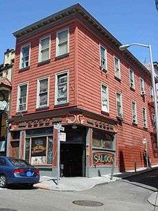
The Saloon

The Saloon, located at 1232 Grant Avenue in North Beach, is currently the oldest saloon of San Francisco and for decades has offered dancing and live music.
History
The Saloon first opened in 1861, and has been in continuous operation ever since.[1]
This drinking establishment was originally owned by Ferdinand E. Wagner, the son of a liquor merchant in Studweiller (Bas Rhin, France), who named it Wagner's Beer Hall. In 1836 Wagner migrated to Louisiana, married a native of Cannes in 1845, and then opened a saloon there.[2] But in 1852 Wagner moved to San Francisco, and first worked as a hotel manager and then as a fruit vendor.[3] He brought his family to San Francisco, and by 1868 he opened Wagner's Beer Hall at 308 Dupont Street. When Dupont Street was renamed as Grant Avenue, it was renumbered as 1232 Grant. Ferdinand and his family lived in the two floors above the bar, and one of his sons would continue to operate the business after Ferdinand retired.
The building looks very much the same as it does in photographs from the 1870s.[4] The elaborate wooden bar which is currently in use was installed in the 1860s, and was constructed outside of America and later shipped to San Francisco. The Saloon is located in the North Beach neighborhood of San Francisco, although in the 1860s its location occurred near the northern border of the Barbary Coast district. During that time the Barbary Coast had scores of dance halls and concert saloons.[5]
In 1906 San Francisco experienced a devastating earthquake and subsequent fire which destroyed most of the buildings in the area. Legend has it that a U.S. Navy frigate which was stationed on the northern waterfront extended a fire hose over Telegraph Hill and pumped water from the bay to fight the flames, thus protecting The Saloon.[6] The aforementioned fire hose is claimed to have also fought the fires of nearby Jackson Square and a wholesale warehouse of liquor, Hotaling's Warehouse, claimed to have been spared from the flames.[7] Historians have commented that establishments which housed or served alcohol seemed to get preferential support from firefighters during the great fire of 1906.[8] But in challenging the belief that The Saloon was spared from the 1906 Fire, there exists a photograph taken from the Lawrence Captive Airship (a series of kites on a very long cord with a suspended camera) on 29th May 1906 that clearly shows the location of The Saloon as a large, burnt hole in the ground. Next door, another large hole in the ground, etc., for most of that block, as well as most of the neighborhood. The alley next to The Saloon as well as Dupont St. is clearly visible and unmistakable. The photograph is located on the wall in back of Spec's Bar at 12 Adler Place (now William Saroyan Place). Contemporary maps on Google Images show The Saloon as being in the zone of North Beach that burned on the 3rd and 4th day.
The Music
In the late 1960s and 1970s Grant Street had numerous blues clubs like The Saloon, which supplied live bands playing music every night. Though many of those blues clubs have disappeared, The Saloon continues to provide a dance floor and daily performances by locally acclaimed musicians. Despite its small size, throughout time The Saloon has attracted the performances of many talented and occasionally famous musicians.
See also
- 1906 San Francisco earthquake
- Barbary Coast
- Gold Rush of 1849
- Jackson Square
- North Beach
- Telegraph Hill
- The Blues
References
- ↑ Richards, Rand: Historic Walks in San Francisco, Heritage House Publishers, 2008, p. 291
- ↑ Chalmers, Claudine: French San Francisco, Arcadia Publishing, 2007, p. 62
- ↑ Richards, Rand: Historic Walks in San Francisco, Heritage House Publishers, 2008, p. 291
- ↑ Chalmers, Claudine: French San Francisco, Arcadia Publishing, 2007, p. 62
- ↑ Cressey, Paul: The Taxi-Dance Hall, University of Chicago Press, 1932, p. 179
- ↑ Richards, Rand: Historic Walks in San Francisco, Heritage House Publishers, 2008, p. 291
- ↑ Richards, Rand: Historic Walks in San Francisco, Heritage House Publishers, 2008, p. 172
- ↑ Richards, Rand: Historic Walks in San Francisco, Heritage House Publishers, 2008, p. 173
Coordinates: 37°47′55″N 122°24′25″W / 37.79857°N 122.40708°W