Grenadines
| Grenadine Islands | |
|---|---|
| Region of the Caribbean | |
 Location within the Grenadines. | |
| Region | Caribbean |
| Island States | |
| Area | |
| • Total | 86 km2 (33 sq mi) |
| Population | |
| • Total | est. 16,100 |
| • Density | 187.2/km2 (485/sq mi) |
| Time zone | AST (UTC−5) |
| • Summer (DST) | ADT (UTC−4) |
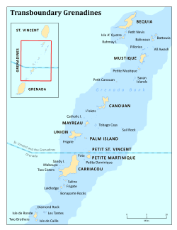
The Grenadines is an island chain that is part of St.Vincent and Grenada. There are 32 islands and cays that make up St. Vincent and the Grenadines (SVG). Nine are inhabited, including the mainland St. Vincent and the Grenadines islands: Young Island, Bequia, Mustique, Canouan, Union Island, Mayreau, Petit St Vincent and Palm Island.
Geographic boundaries
They are divided between the island nations of Saint Vincent and the Grenadines and Grenada. They lie between the islands of Saint Vincent in the north and Grenada in the south. Neither Saint Vincent nor Grenada are Grenadine islands. The islands north of the Martinique Channel belong to Saint Vincent and the Grenadines and the islands south of the channel belong to Grenada.
The larger islands of the Grenadines
Saint Vincent and the Grenadines
The total population of the Grenadine islands in Saint Vincent and the Grenadines is estimated to be 10,234 [1] The following islands make up the Grenadines Parish:
| Island | Area | Pop. | Capital |
|---|---|---|---|
| Northern Grenadines | |||
| Bequia | 18.3 km2 (7.1 sq mi) | 5,000 | Port Elizabeth |
| Mustique | 5.70 km2 (2.20 sq mi) | 800 | Lovell (private island) |
| Southern Grenadines | |||
| Union Island | 9 km2 (3.5 sq mi) | 2,700 | Clifton |
| Canouan | 7.60 km2 (2.93 sq mi) | 1,200 | Port Charlestown |
| Mayreau | 1.20 km2 (300 acres) | 280 | Old Wall |
| Palm Island | 0.55 km2 (140 acres) | Cactus Hill (private island) | |
| Petit Saint Vincent | 0.46 km2 (110 acres) | Telescope Hill (private island) | |
| Non-inhabited Grenadines | |||
| Tobago Cays | 0.25 km2 (62 acres) | marine reserve | |
| Isle à Quatre | 1.52 km2 (380 acres) | ||
| Baliceaux | 1.20 km2 (300 acres) | ||
| Bettowia | 0.71 km2 (180 acres) | ||
| Petit Mustique | 0.40 km2 (99 acres) | ||
| Petit Nevis | 0.29 km2 (72 acres) | ||
| Petit Canouan | 0.20 km2 (49 acres) | ||
| Savan | 0.11 km2 (27 acres) |
Grenada
Carriacou and Petite Martinique is a dependency of Grenada and contains:
| Island | Area | Pop. | Capital |
|---|---|---|---|
| Carriacou | 32.73 km2 (12.64 sq mi) | 6,000 | Hillsborough |
| Petite Martinique | 2.37 km2 (590 acres) | 550 | North Village |
| Non-inhabited Islands | |||
| Ronde Island | 0.37 km2 (91 acres) | ||
| Saline Island | 0.11 km2 (27 acres) | ||
| Large Island | 0.15 km2 (37 acres) | ||
| Frigate Island | 0.09 km2 (22 acres) |
References
- ↑ "St Vincent and the Grenadines, Population and Housing Census Preliminary Report 2012". The Census Office, SVG Government. Retrieved 30 December 2015.
External links
- Grenadines Photo Guide from Paradise Islands (non commercial site)
Coordinates: 12°44′N 61°21′W / 12.733°N 61.350°W