Tatvan
| Tatvan | |
|---|---|
|
Overview of Tatvan from Nemrut-Dagi | |
 Tatvan | |
| Coordinates: 38°30′08″N 42°16′53″E / 38.50222°N 42.28139°ECoordinates: 38°30′08″N 42°16′53″E / 38.50222°N 42.28139°E | |
| Country | Turkey |
| Province | Bitlis |
| Government | |
| • Mayor | Fettah Aksoy (AKP) |
| • Kaymakam | Orhan Şefik Güldibi |
| Area[1] | |
| • District | 1,606.46 km2 (620.26 sq mi) |
| Elevation | 1,690 m (5,540 ft) |
| Population (2012)[2] | |
| • Urban | 67,035 |
| • District | 85,490 |
| • District density | 53/km2 (140/sq mi) |
| Post code | 13200 |
| Website |
www |
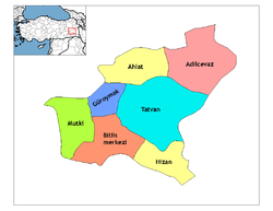
Tatvan (Armenian: Դատվան Datvan, Kurdish: Têtwan) is a city on the western shore of Lake Van. It is the chief city of Tatvan District within Bitlis Province in eastern Turkey, and has about 96,000 inhabitants. The mayor is Fettah Aksoy (AKP).
Transport
Tatvan is the eastern terminus of the railway line from Ankara, with freight and passenger trains. It is connected eastwards to Van, 100 km away, and westwards to the rest of Turkey, by Highway D300. There is also a train ferry across the lake to Van. The ferry was upgraded in 2015.
There is no railway around the lake to Van; it is intended eventually to build one but to date there are no plans. This would actually create an unbroken rail link between Europe and the Indian subcontinent, as Van is effectively the western terminus of the Iranian railway network.
References
- ↑ "Area of regions (including lakes), km²". Regional Statistics Database. Turkish Statistical Institute. 2002. Retrieved 2013-03-05.
- ↑ "Population of province/district centers and towns/villages by districts - 2012". Address Based Population Registration System (ABPRS) Database. Turkish Statistical Institute. Retrieved 2013-02-27.
External links
![]() Media related to Category:Tatvan at Wikimedia Commons
Media related to Category:Tatvan at Wikimedia Commons
.jpg)
