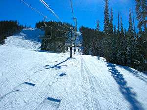
Sunrise Park Resort
| Sunrise Park Resort | |
|---|---|
 Sunrise Panorama | |
| Location | Apache County, Arizona, United States |
| Nearest city | Greer, Arizona |
| Coordinates | 33°58′24″N 109°33′53″W / 33.97333°N 109.56472°WCoordinates: 33°58′24″N 109°33′53″W / 33.97333°N 109.56472°W |
| Vertical | 1,800 ft (550 m) |
| Top elevation | 11,100 feet (3,400 m) |
| Base elevation | 9,200 feet (2,800 m) |
| Skiable area | 800 acres (3.2 km2) |
| Runs |
65 total |
| Longest run | 1.2 miles (1.93 km) "Sidewinder" |
| Lift system | 10 total 3 Quad chairs, 4 triple chairs, 1 double chairs, 2 Surface) |
| Lift capacity | 16,000 / hr |
| Terrain parks | 1 |
| Snowfall | 250 in/year ( 6.35 m/year) |
| Snowmaking | Yes |
| Night skiing | Yes (4:30 p.m. - 9:00 p.m. on limited days) |
| Website | http://www.sunriseskiparkaz.com |
Sunrise Park Resort is a ski resort located near Greer, Arizona. The resort consists of three mountains named Sunrise Peak, Cyclone Peak, and Apache Peak. Situated on the Colorado Plateau and perched atop the White Mountains in eastern Arizona, with a base of 9,200 feet (2,800 m) and spread across 3 peaks and 800 acres (3.2 km2), Sunrise tops out at 11,100 feet (3,400 m) above sea level at Apache Peak.
Ownership and location
It is owned and operated by the White Mountain Apache Tribe, and is located on the Fort Apache Indian Reservation. The resort is a year-round recreation destination and offers a wide range of outdoor activities. During the winter, the resort's three mountains offer excellent alpine skiing. There are plenty of challenging runs for experienced skiers and an abundance of enjoyable intermediate runs. When Arizona experiences wet winters, which aren't all too uncommon, Sunrise provides skiing as good as anywhere in the Southwest. Their ski season usually runs from December to March. Night skiing is occasionally offered in mid-January and mid-February. There is also a snowboard terrain park and separate cross-country skiing area.
Sunrise Park resort is a popular regional destination and is approximately 216 miles (348 km) from Phoenix, Arizona, 231 miles (372 km) from Tucson, Arizona, 223 miles (359 km) from Albuquerque, New Mexico, and 324 miles (521 km) from El Paso, Texas. The closest airports are located in Springerville, Arizona, Show Low, Arizona, and Whiteriver, Arizona.
Mountain statistics
Elevation
The ski area consists of three peaks:
- Sunrise Peak (elevation 10,700')
- Apache Peak (elevation 11,000')
- Base: 9,200 feet (2,800 m)
- Summit: 11,000 feet (3,400 m)
- Vertical drop: 1,800 feet (2nd highest in Arizona)
- Cyclone Circle (elevation 10,700')
Trails
| Easier | More Difficult | Most Difficult |
|---|---|---|
| 31 | 17 | 14 |
The trails on the mountain have some sort of theme, such as Native American and Western names.
- Skiable area: 800 acres (3.2 km2)
- 65 trails
 novice - 40%
 intermediate - 40%
 advanced and expert - 20%
- Longest trail - 1.2 miles (1.9 km)
Lifts


| Name | Capacity | Vertical |
|---|---|---|
| Spirit Ridge Quad | Quad | 3900'-550' |
| Sunrise High-Speed Quad | High-Speed Quad | 6800'-1400' |
| Rustler Quad | Quad | 3950'-875' |
| Fort Apache Triple | Triple | 5180'-620' |
| Cyclone Triple | Triple | 8000'-1165' |
| Eagle Feather Triple | Triple | 4000'-690' |
| Geronimo Triple | Triple | 4505'-1000' |
| Pony Double | Double | 295'-50' |
| Beginner Handle-Tow | Single | 350'-50' |
| Cyclone Handle-Tow | Single | 350'-50 |
- 10 Total
- 3 Quad Chairs
- 4 Triple Chairs
- 1 Double Chairs
- 2 Surface Lifts
- Uphill Capacity - 16,000 skiers per hour
Images
 View from Sunrise Peak
 Out of bounds area
 Moguls run
 Cyclone Peak
 Top of the ski lift on Sunrise Peak
Trivia
- Sunrise Park Resort is Arizona's largest ski resort, but not the highest vertical drop. That honor belongs to Arizona Snowbowl.
- Sunrise Park Resort has been in operation for over 40 years.
- Arizona's second highest peak, Mount Baldy, can be seen from Sunrise.