Subulussalam
| Subulussalam سوبولوسسلام | ||
|---|---|---|
| City | ||
| ||
 Location of Subulussalam in Aceh | ||
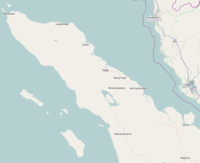
 Subulussalam Location of the city in northern Sumatra | ||
| Coordinates: 2°38′32″N 98°0′15″E / 2.64222°N 98.00417°ECoordinates: 2°38′32″N 98°0′15″E / 2.64222°N 98.00417°E | ||
| Country | Indonesia | |
| Province | Aceh | |
| City | 2 January 2007 | |
| Area | ||
| • Total | 1,206 km2 (466 sq mi) | |
| Population (2010) | ||
| • Total | 67,316 | |
| • Density | 56/km2 (140/sq mi) | |
| Time zone | WIB (UTC+7) | |
| Area code(s) | +62 627 | |
Subulussalam is a city ((Indonesian) Kota) in Aceh province of Indonesia.[1] Since 2 January 2007, the provincial government of Aceh declared Subussalam as city as a result of the administration expansion from Aceh Singkil Regency.[2] It is located at 2°38′32″N 98°00′15″E / 2.6423°N 98.0041°E.[1][3][4][5] As of 2010, the population was 67,316.[6] and has an area of 1206 square kilometres.[4][5]
Administrative divisions
The city is divided administratively into five districts (kecamatan):[2][3]
- Longkip
- Penanggalan
- Rundeng
- Simpang Kiri
- Sultan Daulat
See also
References
- 1 2 "Subulussalam, Indonesia". geographic.org. Bethesda, MD, USA: National Geospatial-Intelligence Agency. 2008-02-29. Retrieved 2011-02-10.
- 1 2 "Act No.8 2007". depdagri.go.id. Indonesian Ministry of Home Affairs. 2007-01-02. Retrieved 2011-02-10.
- 1 2 "Peta Administrasi Subussalam" (PDF). know.arsipan.org. Rehabilitation and Reconstruction Agency (for Aceh and Nais). Retrieved 2011-02-10.
- 1 2 "Profil Subulussalam". acehprov.go.id. Government of Aceh Province. 2010-05-05. Retrieved 2011-02-11.
- 1 2 "KOTA SUBULUSSALAM" (PDF). acehprov.go.id. Government of Aceh Province. Retrieved 2011-02-11.
- ↑ "Website BPS Propinsi Aceh". aceh.bps.go.id. Badan Pusat Statistik. 2011-02-02. Retrieved 2011-02-10.
This article is issued from Wikipedia - version of the 6/23/2016. The text is available under the Creative Commons Attribution/Share Alike but additional terms may apply for the media files.

