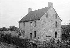
Stover House
|
Stover House | |
|
HABS image of Stover House | |
  | |
| Location | N of Luray off VA 660, near Luray, Virginia |
|---|---|
| Coordinates | 38°43′32″N 78°27′28″W / 38.72556°N 78.45778°WCoordinates: 38°43′32″N 78°27′28″W / 38.72556°N 78.45778°W |
| Area | 4 acres (1.6 ha) |
| Built by | Stover, Samuel |
| Architectural style | Flurkuchenhaus |
| NRHP Reference # | 78003189[1] |
| VLR # | 069-0005 |
| Significant dates | |
| Added to NRHP | May 22, 1978 |
| Designated VLR | November 15, 1977[2] |
Stover House, also known as Fort Stover, is a historic home located near Luray, Page County, Virginia. It is dated to the late-18th century, and is a two-story, three bay, rubble stone structure with a traditional Flurkuchenhaus plan. It has a basement that projects its full height above grade on the river side. Located off the basement is a vaulted room. It is considered among the best preserved and least altered of the important group of 18th-century log and stone German houses of the Massanutten Settlement.[3]
It was listed on the National Register of Historic Places in 1978.[1]
References
- 1 2 National Park Service (2010-07-09). "National Register Information System". National Register of Historic Places. National Park Service.
- ↑ "Virginia Landmarks Register". Virginia Department of Historic Resources. Retrieved 5 June 2013.
- ↑ Virginia Historic Landmarks Commission Staff (October 1977). "National Register of Historic Places Inventory/Nomination: Stover House" (PDF). Virginia Department of Historic Resources. and Accompanying photo
External links
- Fort Stover, State Route 660 vicinity, Luray, Page County, VA: 5 photos, 12 measured drawings, and 4 data pages at Historic American Buildings Survey
This article is issued from Wikipedia - version of the 11/30/2016. The text is available under the Creative Commons Attribution/Share Alike but additional terms may apply for the media files.


