Texas State Highway 64
| ||||
|---|---|---|---|---|
 | ||||
| Route information | ||||
| Maintained by TxDOT | ||||
| Length: | 82.182 mi[1] (132.259 km) | |||
| Existed: | by 1926 – present | |||
| Major junctions | ||||
| West end: |
| |||
|
| ||||
| East end: |
| |||
| Highway system | ||||
| ||||
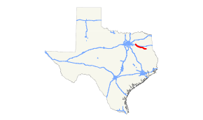
State Highway 64 (SH 64) is a Texas state highway that runs from Wills Point via Tyler to Henderson. (Rusk, Smith, and Van Zandt Counties)
History
SH 64 was originally designated between 1922 and 1926 to replace SH 15A from Wills Point to Carthage, then continuing on to the Louisiana state line. In 1935, the portion east of Henderson was reassigned to U.S. Highway 79. The remaining portion has not changed since.
Major junctions
| County | Location | mi | km | Destinations | Notes |
|---|---|---|---|---|---|
| Van Zandt | Wills Point | Western terminus | |||
| | |||||
| Canton | |||||
| Smith | | ||||
| Tyler | |||||
| West end of US 69 / SH 110 overlaps | |||||
| West end of SH 155 overlap | |||||
| East end of US 69 overlap | |||||
| East end of SH 110 / SH 155 overlaps | |||||
| Arp | |||||
| Rusk | | ||||
| Henderson | |||||
| Eastern terminus | |||||
1.000 mi = 1.609 km; 1.000 km = 0.621 mi
| |||||
Business route
| |
|---|---|
| Location: | Henderson |
| Length: | 3.788 mi[2] (6.096 km) |
| Existed: | 1991–present[2] |
SH 64 has one business route in Henderson, inventoried by TxDOT as Business SH 64-E. The route was designated in 1991, which, along with Bus. US 79, replaced segments of Loop 153 and Loop 154.[3][4] The two business routes are briefly concurrent through downtown Henderson.[2][5]
References
- ↑ Transportation Planning and Programming Division (n.d.). "State Highway No. 64". Highway Designation Files. Texas Department of Transportation. Retrieved January 17, 2015.
- 1 2 3 Transportation Planning and Programming Division (n.d.). "Business State Highway No. 64-E". Highway Designation Files. Texas Department of Transportation. Retrieved August 30, 2013.
- ↑ Transportation Planning and Programming Division (n.d.). "State Highway Loop No. 153". Highway Designation Files. Texas Department of Transportation. Retrieved August 30, 2013.
- ↑ Transportation Planning and Programming Division (n.d.). "State Highway Loop No. 154". Highway Designation Files. Texas Department of Transportation. Retrieved August 30, 2013.
- ↑ Transportation Planning and Programming Division (2012). Texas County Map Book (PDF) (Map) (2012 ed.). 1:120,000. Texas Department of Transportation. p. 573. OCLC 867856197. Retrieved August 30, 2013.
This article is issued from Wikipedia - version of the 1/18/2015. The text is available under the Creative Commons Attribution/Share Alike but additional terms may apply for the media files.
