Stari Grad Plain
| The Stari Grad Plain | |
|---|---|
|
Native name Croatian: Starogradsko polje | |
|
The Stari Grad Plain | |
| Location |
Split-Dalmatia County, |
| Coordinates | 43°10′54″N 16°38′19″E / 43.18167°N 16.63861°ECoordinates: 43°10′54″N 16°38′19″E / 43.18167°N 16.63861°E |
| Type | Cultural |
| Criteria | ii, iii, v |
| Designated | 2008 (32nd Session) |
| Reference no. | 1240 |
| Europe and North America | |
| Official name: Starogradsko polje | |
 Location of The Stari Grad Plain in Croatia | |
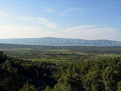
The Stari Grad Plain on the island of Hvar is an agricultural landscape that was set up by the ancient Greek colonists in the 4th century BC, and remains in use. The plain is generally still in its original form. The ancient layout has been preserved by careful maintenance of the stone walls over 24 centuries, along with the stone shelters (known locally as trims[1][2]), and the water collection system. The same crops, mainly grapes and olives, are still grown in the fields, and the site is also a natural reserve. The site is a valuable example of the ancient Greek system of agriculture.[3]
The plain demonstrates the comprehensive system of agriculture as used by the ancient Greeks. The land was divided into geometrical parcels (chora) bounded by dry stone walls. The system included a rainwater recovery system involving the use of gutters and storage cisterns. The original field layout has been respected by the continuous maintenance of the boundary walls by succeeding generations. Agricultural activity in the chora has been uninterrupted for 24 centuries up to the present day. What we see today is a continuation of the cultural landscape of the original Greek colonists.
The Stari Grad Plain is Croatia's 7th location protected by UNESCO.[4][5][6]
References
External links
| Wikimedia Commons has media related to Starogradsko polje. |

