Springwells Village
Naming Origins

Springwells Village is a name used to refer to a neighborhood in southwest Detroit, Michigan, near the Ford Motor Company River Rouge Plant.[1]The name cites the original village founded in 1783 and absorbed by Detroit in 1885. Father Gabriel Richards established the Springwells School in 1820. Another Springwells began in Springwells Township before also being absorbed in 1925. Named for the abundance of springs and wells, the moniker also has roots in non-profit community redevelopment initiatives from around the turn of the century. These initiatives are active to date and range in priority from housing development to resident services to specific site-based redevelopment and community rebranding strategies that generally share the desire to improve the community's image and reputation as well as its presentation in media. At times the neighborhood is also called the Springwells neighborhood in regard to city planning,[2] and most commonly community residents refer to the area as southwest Detroit specifically denoted by nearby intersections of roads (ie. Vernor-Springwells in southwest Detroit).
Urban Neighborhood Initiatives, a local non-profit, is working on a Springwells Village marketing campaign aimed at increasing economic activity for local businesses as well as attracting new businesses and residents to the area. The community rebranding process is being funded as part of a larger initiative of LISC (Local Initiatives Support Corporation) called Building Sustainable Communities which UNI was commissioned to facilitate in the neighborhood surrounding Vernor and Springwells.[3]
Boundaries
The Springwells Village neighborhood is typically defined as the area starting at Dix Hwy. to the north, Waterman St. to east, Fort St. to the south, and Woodmere St. to the west.[4]
Landmarks
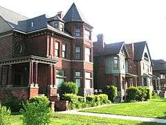
In 2002, the West Vernor-Springwells and the West Vernor-Lawndale Historic Districts in the neighborhood were recognized by the National Register of Historic Places[5] Springwells includes Odd Fellows Hall, a 14,000-square-foot (1,300 m2) historic building built in 1917. Recently restored with funding from Governor Jennifer Granholm's Cool Cities initiative, it is hoped that the Hall will "serve as an anchor to the neighborhood and a magnet for further economic development and job creation."[6]
Education
Detroit Public Schools operates public schools.
High school students are zoned to Western International High School.[7] High school students were previously zoned to Southwestern High School.[8] Southwestern closed in 2012,[9] and students were reassigned to Western..[10]
Additionally several other school districts operate within a short walk from Springwells and Vernor including The Leona Group's Cesar Chavez Academy School District lower elementary, middle, and high school campuses as well as the WAY Academy, a charter high school in Odd Fellow's Hall on the corner of Vernor and Lawndale. Vistas Nuevas Head Start of Matrix Human Services operates several schools in the area as well including the St. Stephens center on Lawndale at Chamberlain, and the Manuel Reyes Center on Vernor at Ferris.
The neighborhood is served by Detroit Public Library's Campbell Branch Library, located at 8733 West Vernor in Springwells. In September 1907 Branch 8, the Delray Branch, opened. The branch was on West End Avenue. In January 1922 a replacement branch, James Valentine Campbell Branch on West 4th Street, operated from January 1922 to December 1996. In July 1999 the Campbell Annex Branch opened at the Holy Redeemer Cultural Center. The branch closed in August 2004. In March 2006 the Campbell Branch Library at Lawndale Station opened.
References
- ↑ "Springwells Village Development Plan". Bridging Communities.
- ↑ "Springwells neighborhood in Detroit, Michigan (MI), 48209 detailed profile". City-Data.com.
- ↑ "Detroit LISC to Invest $30 Million and Launch Next Phase of Building Sustainable Communities in Three Detroit Neighborhoods". PR Newswire.
- ↑ http://bridgingcommunities.org/springwells-village.html
- ↑ Weekly listing of actions taken on properties 12/09/02 through 12/13/02
- ↑ "Southwest Detroit Business Association. Retrieved on July 17, 2009.
- ↑ "High School Boundaries - 2012/13 School Year." (Archive) Detroit Public Schools. Retrieved on November 1, 2012.
- ↑ Detroit Public Schools (2011). "DPS high school boundary map" (PDF). Archived from the original on July 25, 2011. Retrieved November 20, 2011.
- ↑ Foley, Aaron. "Closing southwest Detroit schools would be devastating, protesters say." MLive. Saturday February 25, 2012. Retrieved on November 1, 2012.
- ↑ Satyanarayana, Megha. "Contents of Southwestern High School go up for sale online today." Detroit Free Press. October 18, 2012. Retrieved on November 1, 2012.
Lost Towns of Eastern Michigan, Naldrett, Alan, 2015. https://books.google.com/books?id=VHG4CAAAQBAJ&printsec=frontcover&dq=lost+towns+of+eastern+michigan+springwells+detroit+mi&hl=en&sa=X&ved=0ahUKEwil3PXck7POAhUIYyYKHatSCJMQ6AEIHjAA#v=onepage&q=springwells&f=false
External links
- "Southwest Detroit neighbors cheer demolition of burned-out buildings." Detroit Free Press. July 20, 2012.
- "2 Dead, 1 Injured In Southwest Detroit Shooting" CBS Detroit Local WWJ. September 2, 2011.
Coordinates: 42°18′28″N 83°07′28″W / 42.3078°N 83.1245°W

