Sinuiju Chongnyon Station
Sinŭiju Ch'ŏngnyŏn 신의주청년 | |||||||||||
|---|---|---|---|---|---|---|---|---|---|---|---|
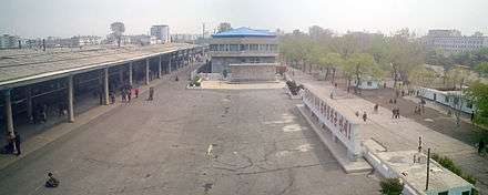
 View of Sinŭiju Ch'ŏngnyŏn station of the platform area. | |||||||||||
| Korean name | |||||||||||
| Hangul | 신의주청년역 | ||||||||||
| Hanja | 新義州青年驛 | ||||||||||
| Revised Romanization | Sinuijucheongnyeon-yeok | ||||||||||
| McCune–Reischauer | Sinŭijuch'ŏngnyŏn-yŏk | ||||||||||
| General information | |||||||||||
| Location |
Sinŭiju, North P'yŏngan North Korea | ||||||||||
| Owned by | Korean State Railway | ||||||||||
| Platforms | 3 (2 island platforms) | ||||||||||
| History | |||||||||||
| Opened | 1911 | ||||||||||
| Rebuilt | 1954? | ||||||||||
| Electrified | yes | ||||||||||
| Services | |||||||||||
| |||||||||||
Sinŭiju Ch'ŏngnyŏn Station is a railway station in Sinŭiju, North P'yŏngan Province, North Korea. It is the northern terminus of the P'yŏngŭi Line of the Korean State Railway .[1]
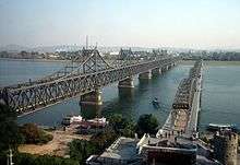
The station is the main recipient for overland traffic between North Korea and People's Republic of China, and is one of the country's most important rail stations, as it controls access to the Chinese city of Dandong over the Yalu River, via the Sino-Korean Friendship Bridge.
History
The Kyŏngŭi Line was opened on 3 April 1906, and general passenger and freight service began on 1 April 1908, but the original station building, a three-story European-style structure, was completed only in 1911. At the same time, the bridge across the Yalu River was opened, connecting the Kyŏngŭi Line to the South Manchurian Railway.
The original three-story European style building was destroyed by UN forces in the Korean War, and the station was rebuilt after the war; it received the current name at the same time, in honour of the Youth Shock Troops who took part in the reconstruction of the station.
Gallery
- Map of Andong (Dandong) and Sinuiju, c. 1930.
- Original station, destroyed during the Korean War.
 Aerial bombing of the Yalu River bridges in 1950.
 The current Sino-Korean Friendship Bridge next to the ruins of the old bridge.
References
- ↑ Kokubu, Hayato, 将軍様の鉄道 (Shōgun-sama no Tetsudō), ISBN 978-4-10-303731-6
Coordinates: 40°06′25″N 124°24′06″E / 40.1070°N 124.4018°E