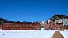
Seodaemun Prison
| Seodaemun Prison | |
| Hangul | 서대문 형무소 |
|---|---|
| Hanja | 西大門刑務所 |
| Revised Romanization | Seodaemun Hyeongmuso |
| McCune–Reischauer | Sŏdaemun Hyŏngmuso |

Seodaemun Prison History Hall is a museum and former prison in Seodaemun-gu, Seoul, South Korea. It was constructed beginning in 1907. The prison was opened on October 21, 1908, under the name Gyeongseong Gamok. Its name was changed to Seodaemun Prison in 1923.
The prison was used during the Colonial period to house liberation activists, and could originally accommodate around 500 people. After the colonial era ended in 1945, the prison was used by the South Korean government until 1987, when it was replaced by a facility in Uiwang City, Gyeonggi Province. In 1992, the site was dedicated as the Seodaemun Prison History Hall, part of Independence Park. Seven of the prison complex's original fifteen buildings are preserved as historical monuments. The History Hall showcases all those imprisoned during the Japanese Colonial Era and continues to serve as a memorial hall.
In 1911, Kim, Koo was imprisoned. He was one of the more important figures in the Korean liberation movement. In 1919, shortly after the March 1st Movement, the number of imprisoned increased drastically. About 3000 liberation activists were imprisoned, and shortly before the colonization ended in 1945, the number of prisoners was at 2980. Among imprisoned after the March 1st Movement was Ryu Gwansun.[1] The Seodaemoon Prison had a separate facility for women and young girls. This is where Ryu Gwansun was tortured and eventually died.
Location
.jpg)
Seodaemun Independence Park, including Seodaemun Prison, is easily accessed from exits 4 or 5 of the Dongnimmun Station on Seoul Subway Line 3.
See also
- Seodaemun Prison History Hall
- Korea under Japanese rule
- List of Korea-related topics
- Independence Gate
References
External links
| Wikimedia Commons has media related to Seodaemun Prison. |
Coordinates: 37°34′28″N 126°57′24″E / 37.57442°N 126.95663°E