Schoellkopf Field
 | |
| Location |
513 Campus Rd Ithaca, NY 14850 |
|---|---|
| Operator | Cornell University |
| Capacity | 25,597 |
| Surface | Artificial Turf |
| Opened | October 9, 1915 |
| Tenants | |
|
Cornell Big Red (Football, sprint football, lacrosse) | |
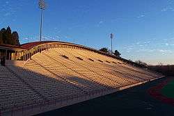
Schoellkopf Field is a 25,597-capacity stadium at Cornell University's Ithaca campus that opened in 1915 and is used for the Cornell Big Red football, sprint football, lacrosse and field hockey teams. It is located just north of Cascadilla Creek on the southern end of the campus, next to Hoy Field and Lynah Rink; Schoellkopf Memorial Hall, adjacent to the stadium, contains the Robison Hall of Fame Room, the hall of fame for Cornell athletics.
History
Following the death of former Cornell football player and head football coach Henry Schoellkopf in 1912, his close friend, Willard Straight, donated $100,000 (equivalent to $2,456,000 in 2015) to construct the Schoellkopf Memorial Hall in honor of Henry Schoellkopf. The building was completed in 1913. In response to Straight's generous gift, members of the Schoellkopf family and the Zeta Psi Fraternity donated $70,000 (equivalent to $1,657,000 in 2015) for the construction of Schoellkopf Field in honor of the Schoellkopf family patriarch, Jacob Schoellkopf, Schoellkopf Field was completed in 1915.[1][2][3][4]
Special events
During May of every year, weather permitting, Schoellkopf is the site of the commencement ceremony for Cornell's Ithaca campus. Schoellkopf Field hosted the Division I NCAA Men's Lacrosse Championship in 1980 and the Drum Corps International World Championships in 1974.
Modifications


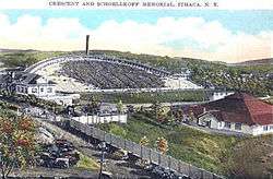
Schoellkopf's original capacity when it was completed was about 9,000, but it has been expanded and changed many times over the years. In 1924, the newly completed "Crescent" replaced the original stands on the east side of the field, increasing seating to about 21,500. In 1947, the stadium's capacity was again increased, this time to a capacity of 25,597, with permanent steel fixtures to the west of the field.[5] The west stands were torn down in March 2016 after falling into disrepair.[6]
In 1971, the surface of the field was converted to "Polyturf", an artificial turf. The field has had its turf replaced by a newer type of turf in 1979, 1988, 1999, and, most recently, in 2008. The press box above and behind the west stands was built in 1986. During the summer of 2005, renovations on deteriorating concrete forced the university to close the Crescent, but it reopened in time for the fall football season. The renovated Memorial Hall at the north end of the field opened in 2006, containing improved locker rooms and training facilities.[5] The Hall was expanded with a 16,000-square-foot (1,500 m2) three-story wing on its east side, with the varsity football locker rooms on the first floor, a Hall of Fame Room on the second floor, and a museum of Cornell football memorabilia on the third floor.[7] Over the summer of 2008, Cornell replaced the artificial turf with a FieldTurf pitch.[8]
References
- ↑ The Schoellkopfs, A Family History, 1994 Copy Held by Cornell University Archives.
- ↑ Guide to the Campus: Cornell University 1920 P 80-82.
- ↑ CORNELL'S NEW STADIUM.; Schoellkopf Field Will Be Ready for Use in the Spring of 1915., The New York Times, August 23, 1914.
- ↑ Schoellkopf Field, Cornell University, retrieved June 18, 2010.
- 1 2 Cornell Big Red.com Schoellkopf facts/history accessed 10-09-2007
- ↑ Cornell Daily Sun
- ↑ http://www.cornellbigred.com/news/football/2004/8/19/081904aai.asp?path=football Retrieved 2008-07-02.
- ↑ FieldTurf Installation on Schoellkopf Field Continues CornellBigRed.com accessed 07-07-2008
External links
| Preceded by Warhawk Stadium |
Host of the Drum Corps International World Championship 1974 |
Succeeded by Franklin Field |
| Preceded by Byrd Stadium |
Home of the NCAA Lacrosse Final Four 1980 |
Succeeded by Palmer Stadium |
Coordinates: 42°26′38.71″N 76°28′43.16″W / 42.4440861°N 76.4786556°W